Elk Garden, West Virginia

Last updated

Elk Garden, West Virginia
2016-06-18 09 50 01 View north along West Virginia State Route 42 (Cottage Street) entering Elk Garden, Mineral County, West Virginia.jpg
View entering Elk Garden from the south via West Virginia Route 42
Mineral County West Virginia Incorporated and Unincorporated areas Elk Garden Highlighted.svg
Location of Elk Garden in Mineral County, West Virginia.
Coordinates: 39°23′10″N79°09′20″W / 39.38611°N 79.15556°W / 39.38611; -79.15556
Country United States
State West Virginia
County Mineral
Area
[1]
  Total0.26 sq mi (0.67 km2)
  Land0.26 sq mi (0.67 km2)
  Water0.00 sq mi (0.00 km2)
Elevation
[2]
2,264 ft (690 m)
Population
 (2020) [3]
  Total211
  Estimate 
(2021) [3]
210
  Density821.71/sq mi (317.81/km2)
Time zone UTC-5 (Eastern (EST))
  Summer (DST) UTC-4 (EDT)
ZIP code
26717
Area code 304
FIPS code 54-24484 [4]
GNIS feature ID2390165 [2]
Website www.mineralcountywv.com/elkgarden/index.asp

Elk Garden is a town in Mineral County, West Virginia, United States. It is part of the 'Cumberland, MD-WV Metropolitan Statistical Area'. The population was 211 at the 2020 census. [3] Elk Garden High School was consolidated into Keyser High School in 1997. [5] However the Primary School is still in session, offering classes from Pre-Kindergarten through the fifth grade. The school mascot is the Elk Garden Stags. [6] Elk Garden was incorporated in 1890 by the Mineral County Circuit Court. It is named for an elk lick near the original town site. [7]

Contents

Geography

According to the United States Census Bureau, the town has a total area of 0.26 square miles (0.67 km2), all land. [8]

Transportation

Route 42 northbound leaving Elk Garden 2016-06-18 08 45 33 View north along West Virginia State Route 42 (Blaine Highway) at Cottage Street in Elk Garden, Mineral County, West Virginia.jpg
Route 42 northbound leaving Elk Garden

The only significant highway directly serving Elk Garden is West Virginia Route 42. Route 42 continues north to Maryland and extends southward to U.S. Route 50 and beyond to Petersburg. Just east of Elk Garden, West Virginia Route 46 has its western terminus at Route 42. Route 46 continues northeast, eventually reaching Luke.

Demographics

Historical population
CensusPop.Note
1890 723
1900 581−19.6%
1910 438−24.6%
1920 422−3.7%
1930 299−29.1%
1940 34214.4%
1950 318−7.0%
1960 3293.5%
1970 291−11.6%
1980 2910.0%
1990 261−10.3%
2000 217−16.9%
2010 2326.9%
2020 211−9.1%
2021 (est.)210 [3] −0.5%
U.S. Decennial Census [9]

2010 census

As of the census [10] of 2010, there were 232 people, 92 households, and 69 families living in the town. The population density was 892.3 inhabitants per square mile (344.5/km2). There were 108 housing units at an average density of 415.4 per square mile (160.4/km2). The racial makeup of the town was 98.3% White and 1.7% from two or more races.

There were 92 households, of which 34.8% had children under the age of 18 living with them, 53.3% were married couples living together, 13.0% had a female householder with no husband present, 8.7% had a male householder with no wife present, and 25.0% were non-families. 22.8% of all households were made up of individuals, and 13.1% had someone living alone who was 65 years of age or older. The average household size was 2.52 and the average family size was 2.93.

The median age in the town was 41 years. 22.8% of residents were under the age of 18; 7.9% were between the ages of 18 and 24; 25.8% were from 25 to 44; 27.7% were from 45 to 64; and 15.9% were 65 years of age or older. The gender makeup of the town was 51.7% male and 48.3% female.

2000 census

As of the census [4] of 2000, there were 217 people, 89 households, and 59 families living in the town. The population density was 826.0 inhabitants per square mile (318.9/km2). There were 103 housing units at an average density of 392.1 per square mile (151.4/km2). The racial makeup of the town was 98.62% White, 0.46% African American, and 0.92% from two or more races.

There were 89 households, out of which 31.5% had children under the age of 18 living with them, 48.3% were married couples living together, 15.7% had a female householder with no husband present, and 32.6% were non-families. 29.2% of all households were made up of individuals, and 12.4% had someone living alone who was 65 years of age or older. The average household size was 2.44 and the average family size was 3.00.

In the town, the population was spread out, with 23.5% under the age of 18, 8.8% from 18 to 24, 26.3% from 25 to 44, 28.6% from 45 to 64, and 12.9% who were 65 years of age or older. The median age was 40 years. For every 100 females, there were 104.7 males. For every 100 females age 18 and over, there were 97.6 males.

The median income for a household in the town was $24,375, and the median income for a family was $26,964. Males had a median income of $26,071 versus $13,125 for females. The per capita income for the town was $11,453. About 21.7% of families and 22.9% of the population were below the poverty line, including 21.7% of those under the age of eighteen and 20.8% of those 65 or over.

Related Research Articles

<span class="mw-page-title-main">Elk Falls, Kansas</span> City in Elk County, Kansas

Elk Falls is a city in Elk County, Kansas, United States, along the Elk River. As of the 2020 census, the population of the city was 113.

<span class="mw-page-title-main">Westernport, Maryland</span> Town in Maryland, United States

Westernport is a town in Allegany County, Maryland, United States, along the Georges Creek Valley. It is part of the Cumberland, MD-WV Metropolitan Statistical Area. The population was 1,888 at the 2010 census.

<span class="mw-page-title-main">Danville, West Virginia</span> Town in West Virginia, United States

Danville is a town in Boone County, West Virginia, United States. The population was 660 at the 2020 census. Danville was incorporated in 1911 and named for Dan Rock, the town's first postmaster. Danville was formerly known as Newport and Red House.

<span class="mw-page-title-main">Sylvester, West Virginia</span> Town in West Virginia, United States

Sylvester is a town in Boone County, West Virginia, United States, along the Big Coal River. The population was 166 at the 2020 census. Sylvester was incorporated on April 11, 1952 by the Boone County Circuit Court. Sylvester bears the name of a family of settlers.

<span class="mw-page-title-main">Sutton, West Virginia</span> Town in West Virginia

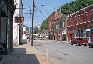
Sutton is a town in Braxton County, West Virginia, United States. The population was 876 at the 2020 census. It is the county seat of Braxton County. Sutton is situated at a center of transportation in West Virginia. Interstate 79, a major north–south route, connects with Appalachian Corridor L, another significant north–south route, passes several miles south of town.

<span class="mw-page-title-main">Clay, West Virginia</span> Town in West Virginia, United States

Clay is a town in and the county seat of Clay County, West Virginia, United States. The population was 399 at the 2020 census. It is the only incorporated town in Clay County.

<span class="mw-page-title-main">Bayard, West Virginia</span> Town in West Virginia, United States

Bayard is a town in Grant County, West Virginia, United States. The population was 200 at the 2020 census. Bayard was incorporated in 1893 and named in honor of Thomas F. Bayard, Jr., who later became a United States senator from Delaware (1923–1929). Bayard was founded on the West Virginia Central and Pittsburgh Railroad as a coal mining community. Coal mining has remained the town's chief industry.

<span class="mw-page-title-main">Petersburg, West Virginia</span> City in West Virginia, United States

Petersburg is a city in Grant County, West Virginia, United States. The population was 2,251 at the 2020 census. It is the county seat of Grant County.

<span class="mw-page-title-main">Capon Bridge, West Virginia</span> Town in West Virginia, United States

Capon Bridge is a town in eastern Hampshire County, West Virginia, United States, along the Northwestern Turnpike, approximately 20 miles (32 km) west of Winchester, Virginia. The population was 418 at the 2020 census. Originally known as "Glencoe", Capon Bridge was incorporated in 1902 by the Hampshire County Circuit Court. It is named because of the construction of the bridge over the Cacapon River at that place, the name of the river being derived from the Shawnee Cape-cape-de-hon, meaning "river of medicine water".

<span class="mw-page-title-main">Nutter Fort, West Virginia</span> Town in West Virginia, United States

Nutter Fort is a town in Harrison County, West Virginia, United States, incorporated in 1923. The town is a southeastern suburb of Clarksburg.

<span class="mw-page-title-main">Stonewood, West Virginia</span> City in West Virginia, United States

Stonewood is a city in Harrison County, West Virginia, United States. The population was 1,810 at the 2020 census.

<span class="mw-page-title-main">West Logan, West Virginia</span> Town in West Virginia, United States

West Logan is a town along the Guyandotte River in Logan County, West Virginia, United States. The population was 400 at the 2020 census. For unknown reasons, some sources report West Logan to lay west of the county seat at Logan, attributing to this fact the name.

<span class="mw-page-title-main">Worthington, West Virginia</span> Town in West Virginia, United States

Worthington is a town in Marion County, West Virginia, United States. The population was 158 at the 2010 census. Worthington was incorporated in 1893 and named for Colonel George Worthington, an early settler. U.S. Route 19 passes through the town.

<span class="mw-page-title-main">Northfork, West Virginia</span> Town in West Virginia, United States

Northfork is a town in McDowell County, West Virginia, United States, located on U.S. Route 52 between Welch and Bluefield.

<span class="mw-page-title-main">Oakvale, West Virginia</span> Town in West Virginia, United States

Oakvale is a town in Mercer County, West Virginia, United States, along the East River. The population was 137 at the 2020 census. It is part of the Bluefield, WV-VA micropolitan area which has a population of 107,578.

<span class="mw-page-title-main">Lester, West Virginia</span> Town in West Virginia, United States

Lester is a town in Raleigh County, West Virginia, United States. The population was 337 at the 2020 census. The community was named after Champ Lester, a local pioneer.

<span class="mw-page-title-main">Harman, West Virginia</span> Town in West Virginia, United States

Harman is a town in Randolph County, West Virginia, United States. The population was 96 at the 2020 census.

<span class="mw-page-title-main">Cairo, West Virginia</span> Town in West Virginia, United States

Cairo is a town in Ritchie County, West Virginia, United States, along West Virginia Route 31, the North Fork of the Hughes River, and the North Bend Rail Trail. The population was 174 at the 2020 census.

<span class="mw-page-title-main">Ellenboro, West Virginia</span> Town in West Virginia, United States

Ellenboro is a town in Ritchie County, West Virginia, United States. The population was 222 at the 2020 census. The town is located at the junction of U.S. Route 50 and West Virginia Route 16; the North Bend Rail Trail also passes through the town. The town was named for Ellen Mariah Williamson, the eldest daughter of the family that granted a right of way for the Baltimore and Ohio Railroad to build their line through the town; an earlier name for the community was Shumley. Ellenboro was incorporated in 1903.

<span class="mw-page-title-main">Hundred, West Virginia</span> Town in West Virginia, United States

Hundred is a town in Wetzel County, West Virginia, United States. The population was 257 at the 2020 census. It was named for the fact that local resident Henry "Old Hundred" Church was a centenarian. Hundred is the only place in the United States with this name.

References

  1. "2019 U.S. Gazetteer Files". United States Census Bureau. Retrieved August 7, 2020.
  2. 1 2 U.S. Geological Survey Geographic Names Information System: Elk Garden, West Virginia
  3. 1 2 3 4 "City and Town Population Totals: 2020-2021". Census.gov. US Census Bureau. Retrieved July 3, 2022.
  4. 1 2 "U.S. Census website". United States Census Bureau . Retrieved January 31, 2008.
  5. "West Virginia High Schools - Alumni Apparel, Reunions and Yearbooks". classicschools.com. Retrieved August 30, 2018.
  6. "Elk Garden Primary School". Archived from the original on August 5, 2012. Retrieved November 12, 2012.
  7. Kenny, Hamill (1945). West Virginia Place Names: Their Origin and Meaning, Including the Nomenclature of the Streams and Mountains. Piedmont, WV: The Place Name Press. p. 225.
  8. "US Gazetteer files 2010". United States Census Bureau. Archived from the original on January 25, 2012. Retrieved January 24, 2013.
  9. "Census of Population and Housing". Census.gov. Retrieved June 4, 2015.
  10. "U.S. Census website". United States Census Bureau . Retrieved January 24, 2013.