Henderson, North Carolina | |
---|---|
Nicknames: The Gateway City, Triangle North, Lil’ Durham, The Gate's | |
Motto(s): "Progress, Pride, Potential" | |
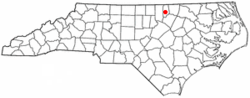
Coordinates: 36°19′33″N78°24′55″W / 36.32583°N 78.41528°W | |
Country | United States |
State | North Carolina |
County | Vance |
Named for | Leonard Henderson [1] |
Government | |
• Type | Municipality |
Area | |
• Total | 8.63 sq mi (22.35 km2) |
• Land | 8.62 sq mi (22.34 km2) |
• Water | 0.01 sq mi (0.01 km2) |
Elevation | 440 ft (130 m) |
Population (2020) | |
• Total | 15,060 |
• Density | 1,746.29/sq mi (674.21/km2) |
Demonym | Hendersonian |
Time zone | UTC−5 (Eastern (EST)) |
• Summer (DST) | UTC−4 (EDT) |
ZIP codes | 27536-27537 |
Area code | 252 |
FIPS code | 37-30660 [4] |
GNIS feature ID | 2404683 [3] |
Website | henderson.nc.gov |
Henderson is a city and the county seat of Vance County, North Carolina, United States. [5] The population was 15,060 at the 2020 census. [6]
The city was named in honor of former North Carolina Supreme Court Chief Justice Leonard Henderson, who lived nearby and was a friend of early settler Lewis Reavis. Henderson was officially chartered by the North Carolina General Assembly in 1841.
Prior to the creation of Vance County in 1881, Henderson was located in far eastern Granville County. [7]
Ashland, Henderson Central Business Historic District, Henderson Fire Station and Municipal Building, Library and Laboratory Building-Henderson Institute, Mistletoe Villa, Maria Parham Hospital, Daniel Stone Plank House, Vance County Courthouse, West End School, Zollicoffer's Law Office, and Barker House are listed on the National Register of Historic Places. [8] [9]
According to the United States Census Bureau, the city has a total area of 8.2 square miles (21 km2), of which 8.2 square miles (21 km2) is land and 0.12% is water.
Henderson benefits from its location near Interstate 85 and U.S. 1. Highway 39 also runs through Henderson.
Census | Pop. | Note | %± |
---|---|---|---|
1860 | 186 | — | |
1870 | 1,635 | 779.0% | |
1880 | 1,421 | −13.1% | |
1890 | 4,191 | 194.9% | |
1900 | 3,746 | −10.6% | |
1910 | 4,503 | 20.2% | |
1920 | 5,222 | 16.0% | |
1930 | 6,345 | 21.5% | |
1940 | 7,647 | 20.5% | |
1950 | 10,996 | 43.8% | |
1960 | 12,740 | 15.9% | |
1970 | 13,896 | 9.1% | |
1980 | 13,522 | −2.7% | |
1990 | 15,655 | 15.8% | |
2000 | 16,095 | 2.8% | |
2010 | 15,368 | −4.5% | |
2020 | 15,060 | −2.0% | |
2021 (est.) | 14,954 | [10] | −0.7% |
U.S. Decennial Census [11] [12] |
Race | Number | Percentage |
---|---|---|
White (non-Hispanic) | 3,453 | 22.93% |
Black or African American (non-Hispanic) | 9,720 | 64.54% |
Native American | 37 | 0.25% |
Asian | 171 | 1.14% |
Pacific Islander | 2 | 0.01% |
Other/Mixed | 408 | 2.71% |
Hispanic or Latino | 1,269 | 8.43% |
As of the 2020 United States census, there were 15,060 people, 5,715 households, and 3,549 families residing in the city.
At the 2000 census there were 16,095 people, 6,332 households, and 4,122 families living in the city. The population density was 1,953.7 inhabitants per square mile (754.3/km2). There were 6,870 housing units at an average density of 833.9 per square mile (322.0/km2). The racial makeup of the city was 59.17% African American, 32.76% White, 0.27% Native American, 0.64% Asian, 0.02% Pacific Islander, 2.36% from other races, and 0.77% from two or more races. Hispanic or Latino of any race were 5.13%. [4]
Of the 6,332 households 31.3% had children under the age of 18 living with them, 34.1% were married couples living together, 26.7% had a female householder with no husband present, and 34.9% were non-families. 30.7% of households were one person and 14.4% were one person aged 65 or older. The average household size was 2.47 and the average family size was 3.05.
The age distribution was 27.4% under the age of 18, 8.9% from 18 to 24, 26.8% from 25 to 44, 20.6% from 45 to 64, and 16.4% 65 or older. The median age was 36 years. For every 100 females, there were 82.2 males. For every 100 females age 18 and over, there were 75.5 males.
The median household income was $23,745 and the median family income was $30,222. Males had a median income of $26,804 versus $19,910 for females. The per capita income for the city was $15,130. About 23.4% of families and 28.3% of the population were below the poverty line, including 40.5% of those under age 18 and 20.9% of those age 65 or over.
Henderson is located on the S-Line, the former main line of the Seaboard Air Line Railroad now owned by CSX Transportation. The city was last served by passenger rail in 1986, at which time Amtrak's long-distance Silver Star was re-routed through Rocky Mount and part of the S-Line was abandoned. [14] Restoration of the line is planned as part of the Southeast High Speed Rail Corridor project.
Montgomery County is a rural county located in the southern Piedmont of the U.S. state of North Carolina. As of the 2020 census, the population was 25,751. Its county seat is Troy.
Wilson County is a county located in the U.S. state of North Carolina. As of the 2020 census, the population was 78,784. The county seat is Wilson. The county comprises the Wilson, NC Micropolitan Statistical Area, which is also included within the Rocky Mount-Wilson-Roanoke Rapids, NC Combined Statistical Area.
Vance County is a county located in the U.S. state of North Carolina. As of the 2020 census, the population was 42,578. Its county seat is Henderson.
Rutherford County is a county in the southwestern area of the U.S. state of North Carolina. As of the 2020 census, the population was 64,444. Its county seat is Rutherfordton. Rutherford County comprises the Forest City, NC Micropolitan Statistical Area.
Polk County is a county located in the U.S. state of North Carolina. As of the 2020 census, the population was 19,328. Its county seat is Columbus.
Perquimans County is a county located in the U.S. state of North Carolina. As of the 2020 census, the population was 13,005. Its county seat is Hertford. The Harvey Point Defense Testing Activity facility is located in Perquimans County.
PamlicoCounty is a county located in the U.S. state of North Carolina. As of the 2020 census, the population was 12,276. Its county seat is Bayboro.
Pasquotank County is a county located in the U.S. state of North Carolina. As of the 2020 census, the population was 40,568. Its county seat is Elizabeth City.
Martin County is a county located in the U.S. state of North Carolina. As of the 2020 census, the population was 22,031. Its county seat is Williamston.
Duplin County is a county located in the U.S. state of North Carolina. As of the 2020 census, the population was 48,715. Its county seat is Kenansville.
Davie County is a county located in the U.S. state of North Carolina. As of the 2020 census, the population was 42,712. Its county seat is Mocksville.
Beaufort County is a county located in the U.S. state of North Carolina. As of the 2020 census, the population was 44,652. Its county seat is Washington. The county was founded in 1705 as Pamptecough Precinct. Originally included in Bath County, it was renamed Beaufort Precinct in 1712 and became Beaufort County in 1739.
Halifax is a town in Halifax County, North Carolina, United States. The population was 234 at the 2010 census. It is the county seat of Halifax County. It is known as "The Birthplace of Freedom" for being the location for the April 12, 1776, adoption of the Halifax Resolves, which was the first official action by a colony calling for independence. Halifax is also home to the Halifax Historic District, a historic site operated by the North Carolina Department of Cultural Resources. Halifax is part of the Roanoke Rapids, North Carolina Micropolitan Statistical Area.
Weldon is a town in Halifax County, North Carolina, United States. The population was 1,655 at the 2010 census. It is part of the Roanoke Rapids, North Carolina Micropolitan Statistical Area.
Hendersonville is a city in and the county seat of Henderson County, North Carolina, United States, located 22 miles (35 km) south of Asheville. Like the county, the city is named for 19th-century North Carolina Supreme Court Chief Justice Leonard Henderson.
Nashville is a town in Nash County, North Carolina, United States. The town was founded in 1780 and features Victorian and Queen Anne style homes. It is part of the Rocky Mount, North Carolina Metropolitan Statistical Area. The population of Nashville was 5,632 in 2020. It is the county seat of Nash County. The town and its county were named for Francis Nash, an officer of the North Carolina militia who died in the American Revolutionary War.
Reidsville is a city in Rockingham County in the U.S. state of North Carolina. At the 2020 census, the city had a total population of 14,583. Reidsville is included in the Greensboro–High Point Metropolitan Statistical Area of the Piedmont Triad.
Wagram is a town in Scotland County, North Carolina, United States. The population was 840 at the 2010 census. The town was named for the Battle of Wagram, a Napoleonic battle at Deutsch-Wagram in Austria.
Middleburg is a town in Vance County, North Carolina, United States. The population was 133 at the 2010 census. It was in Warren County and known as Middleburgh prior to the establishment of Vance County in 1881.
Archdale is a city in Guilford and Randolph counties in the U.S. state of North Carolina. Located 15 miles southwest of Greensboro, it is part of the Greensboro-High Point Metropolitan Statistical Area of the Piedmont Triad metro region. The population of the city was 11,907 at the 2020 census.