
Aberdeen Township is a township in Monmouth County, New Jersey, United States. The township is located within the Raritan Valley region and is a part of the New York Metropolitan Area. As of the 2010 United States Census, the township's population was 18,210, reflecting an increase of 756 (+4.3%) from the 17,454 counted in the 2000 Census, which had in turn increased by 416 (+2.4%) from the 17,038 counted in the 1990 Census.

Parkway Pines is an unincorporated community located along the border of Howell Township in Monmouth County and Brick Township in Ocean County, in New Jersey, United States. The Howell area of this community is called Ramtown.

Millhurst is an unincorporated community located within Manalapan Township in Monmouth County, New Jersey, United States. Route 33 and County Route 527 pass through the center of Millhurst. Much of the area consists of businesses along the aforementioned arterial roads with the Millhurst Mill at the CR 527 crossing of Manalapan Brook. The mill is a former grist mill built in the 1700s, rebuilt in the 1800s as a more efficient mill, and turned into a family business by Bernard Hochberg in 1925.

Georgia is an unincorporated community located within Freehold Township in Monmouth County, New Jersey, United States. Exit 22 on Interstate 195 provides access to Georgia via Jackson Mills Road. There is also a road in the area called Georgia Road, leading to Turkey Swamp Park. Georgia sits at the northern reaches of the Pine Barrens and numerous housing developments are located north and east of the settlement.

Applegarth is an unincorporated community located within Monroe Township in Middlesex County, New Jersey, United States. The settlement is located in the southern portion of the township and is traversed by the road of the same name, Applegarth Road. At the location of the original settlement, at the intersection of Applegarth, Wycoffs Mills, and Old Church Roads, there is a restaurant, farmland, and the Applegarth Fire Department. Further north along Applegarth Road are housing developments, age-restricted communities, and two elementary schools: Applegarth and Oak Tree.

Burrs Mill is an unincorporated community located within Southampton Township in Burlington County, New Jersey, United States. Found in a rural portion of the township near Route 70, it is located along its eponymous brook in a forested area within the Pine Barrens. A low density of houses surround nearby roads including Burrs Mill Road and Route 70's fire roads.
Carsons Mills is an unincorporated community located within Robbinsville Township in Mercer County, New Jersey, United States. The community is located at the junctions of the Assunpink Creek and the New Sharon Branch creek and Sharon Road and Windsor Road southeast of the New Jersey Turnpike. Developed areas nearby include small residences and farmland while the undeveloped areas are forest and floodplains as a part of the Assunpink Wildlife Management Area.

Nesco is an unincorporated community in Mullica Township, Atlantic County, New Jersey, United States.

McCrea Mills is an unincorporated community located within Readington Township in Hunterdon County, New Jersey, United States.

Rockefellows Mills is an unincorporated community located within Raritan Township in Hunterdon County, New Jersey, United States. The settlement is located along the South Branch Raritan River near Three Bridges. The river is spanned in the area by a 1910-constructed Pratt through truss bridge. Most of the area within the Raritan Township side of the river is forested however on the north side of the river in Readington Township, some farmland dots the area.

Fresh Ponds is an unincorporated community located within South Brunswick Township in Middlesex County, New Jersey, United States. It is located in a rural portion of the township at the intersection of Fresh Ponds Road and Davidson Mill Road. Forest land, farms, homes, and a church are located around the settlement.

Middlesex Downs is an unincorporated community located within Monroe Township in Middlesex County, New Jersey, United States. The wholly residential settlement contains small homes along Dey Grove Road and Bergen Mills Road with larger homes in developments towards the south. The township-owned James Monroe Memorial Park is also located in this settlement. Much of the area to the north of Dey Grove Road consists of forest land but at one time this was planned to become a large planned community arranged in a street grid. The small property parcels and paper streets remain on township tax maps today.

Wyckoffs Mills is an unincorporated community located along the border of Cranbury and Monroe townships in Middlesex County, New Jersey, United States. Located at the intersection of Wyckoff Mills Road and Wyckoffs Mills Road, the area only contains lots containing residential structures; the remainder of the land is made up of farmland and wetlands. The Millstone River flows to the south of the settlement and a 500-kilovolt transmission line crosses the farmland to the north and south.

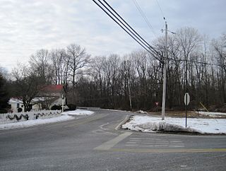
Green Grove is an unincorporated community located where the boundaries of Neptune Township, Ocean Township and Tinton Falls Borough intersect in Monmouth County, New Jersey, United States.

Kirbys Mills is an unincorporated community located within Upper Freehold Township in Monmouth County, New Jersey, United States. Centered near the intersection of Burlington Path Road and Holmes Mill Road, the area consists of housing developments and small farms.

Lower Squankum is an unincorporated community located within Howell Township in Monmouth County, New Jersey, United States. The settlement is located along Lakewood-Farmingdale Road at its intersection with Herbertsville Road and Old Tavern Road in the eastern side of the township. It is also located near the boundary of Allaire State Park and is south of Interstate 195's exit 31. Nearby the community are the remains of the Lower Squankum Mill and the Lower Squankum Friends Burial Site, located within the median of CR 547 at the aforementioned interchange.
Oakland Mills is an unincorporated community located within Manalapan Township in Monmouth County, New Jersey, United States. The area is named for Oakland Mill, a mill along the Manalapan Brook operated by the Boo family. Some areas within the Manalapan Brook valley and surround forestland are preserved while the remainder of the area surrounding Oakland Mills has since been developed into housing developments.

Headquarters is an unincorporated community located within Delaware Township in Hunterdon County, New Jersey, United States. The settlement is centered aon the crossing of Zentek Road over the Caponockons Creek, near the intersection of Zentek Road and Ringoes-Rosemont Road. The area is part of the Headquarters Historic District, a listing on the National Register of Historic Places. Headquarters was the site of a mill established in 1735, one of the first in Hunterdon County. The industry thrived until the early 20th century when the mill shut down. The district was first established as a historic area by Delaware Township in the 1980s to push back against a widening of CR 604. It is now on the national list of historic districts with a renewal of its boundaries occurring in 2016.

Spring Mill is an unincorporated community located within Upper Freehold Township in Monmouth County, New Jersey, United States. The settlement is located along County Route 524 between Hamilton Township and Allentown on a commercialized segment of the road originally built as New Jersey Route 37. A vestige of the state construction remains along the road through a wide right-of-way and a bridge crossing Doctor's Creek stating that it was constructed by the state in 1940 for State Highway Route 37.

Dunns Mill or Dunns Mills is an unincorporated community located within Bordentown Township in Burlington County, New Jersey, United States. The site is named for a gristmill established in 1708 that is located near the settlement along Blacks Creek. Martin Luther Dunn purchased the mill in 1875 but burned down in 1901. The site is presently located near the crossing of the New Jersey Turnpike over County Route 545. A mix of housing developments and preserved open space are located around Dunns Mill today.


