Madison, West Virginia

Last updated

Madison
Madison West Virginia.jpg
Main Street in Madison in 2007
Nickname: 
The Gateway to the Coal Fields
Boone County West Virginia Incorporated and Unincorporated areas Madison Highlighted.svg
Location of Madison in Boone County, West Virginia.
Coordinates: 38°3′43″N81°49′6″W / 38.06194°N 81.81833°W / 38.06194; -81.81833
Country United States
State West Virginia
County Boone
Area
[1]
  Total7.06 sq mi (18.29 km2)
  Land7.01 sq mi (18.14 km2)
  Water0.06 sq mi (0.15 km2)
Elevation
702 ft (214 m)
Population
 (2020) [2]
  Total2,911
  Estimate 
(2021) [2]
2,838
  Density381.53/sq mi (147.32/km2)
Time zone UTC-5 (Eastern (EST))
  Summer (DST) UTC-4 (EDT)
ZIP code
25130
Area code 304
FIPS code 54-50524 [3]
GNIS feature ID1542678 [4]
Website madisonwv.org

Madison is a city and former coal town in Boone County, West Virginia, United States. The population was 2,911 at the 2020 census. [2] It is the county seat of Boone County. [5]

Contents

History

Madison was first established as Boone Court House. The town was renamed circa 1865, presumably for James Madison, the fourth president of the United States. Other theories hold that it was named for lawyer James Madison Laidley or for William Madison Peyton, a pioneer coal operator, who was a leader in the movement which resulted in the formation of Boone County and for whom Peytona on Big Coal River was also named. Madison was incorporated in 1906. [6]

The first courthouse at Madison, a log structure, was burned by Union troops early in the Civil War. The second courthouse, made of local brick, served until 1913, and a frame building was used by county officials for the next several years. The present Boone County Courthouse, occupied in 1921, is listed on the National Register of Historic Places. [7]

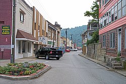
Madison is the "Gateway to the Coalfields," as it is located on a principal route through the southern coalfields. It occupied a strategic place during the Mine Wars. Miners twice rallied at the town ballpark in August 1921, to consider whether to continue their march to neighboring Logan and Mingo counties. Thousands of armed marchers passed through the town and surrounding region on their way to and from the fighting at Blair Mountain, which is located up Spruce Fork from Madison. [6]

In addition to the Boone County Courthouse, the Madison National Bank building is listed on the National Register of Historic Places. [7]

Geography

Madison is located at 38°3′43″N81°49′6″W / 38.06194°N 81.81833°W / 38.06194; -81.81833 (38.061816, -81.818216). [8] The Little Coal River is formed at Madison by the confluence of its Spruce Fork and its Pond Fork.

According to the United States Census Bureau, the city has a total area of 7.07 square miles (18.31 km2), of which 7.01 square miles (18.16 km2) is land and 0.06 square miles (0.16 km2) is water. [9]

Climate

Climate data for Madison, West Virginia (1991–2020 normals, extremes 1894–present)
MonthJanFebMarAprMayJunJulAugSepOctNovDecYear
Record high °F (°C)82
(28)
83
(28)
89
(32)
96
(36)
98
(37)
100
(38)
104
(40)
103
(39)
101
(38)
97
(36)
89
(32)
80
(27)
104
(40)
Mean maximum °F (°C)69.4
(20.8)
72.5
(22.5)
80.4
(26.9)
87.9
(31.1)
89.9
(32.2)
93.5
(34.2)
95.2
(35.1)
94.1
(34.5)
92.0
(33.3)
85.6
(29.8)
78.8
(26.0)
70.2
(21.2)
96.4
(35.8)
Mean daily maximum °F (°C)44.8
(7.1)
48.7
(9.3)
57.7
(14.3)
70.1
(21.2)
77.5
(25.3)
84.2
(29.0)
87.2
(30.7)
86.2
(30.1)
81.0
(27.2)
70.3
(21.3)
58.6
(14.8)
48.3
(9.1)
67.9
(19.9)
Daily mean °F (°C)34.7
(1.5)
37.8
(3.2)
45.3
(7.4)
55.9
(13.3)
65.0
(18.3)
72.6
(22.6)
76.3
(24.6)
75.2
(24.0)
69.0
(20.6)
57.2
(14.0)
46.0
(7.8)
38.4
(3.6)
56.1
(13.4)
Mean daily minimum °F (°C)24.6
(−4.1)
26.9
(−2.8)
33.0
(0.6)
41.7
(5.4)
52.4
(11.3)
61.0
(16.1)
65.4
(18.6)
64.1
(17.8)
56.9
(13.8)
44.2
(6.8)
33.4
(0.8)
28.4
(−2.0)
44.3
(6.8)
Mean minimum °F (°C)4.3
(−15.4)
8.4
(−13.1)
15.5
(−9.2)
26.8
(−2.9)
36.6
(2.6)
48.2
(9.0)
55.9
(13.3)
54.3
(12.4)
43.5
(6.4)
29.8
(−1.2)
19.3
(−7.1)
12.3
(−10.9)
1.2
(−17.1)
Record low °F (°C)−25
(−32)
−19
(−28)
−8
(−22)
20
(−7)
27
(−3)
35
(2)
40
(4)
42
(6)
30
(−1)
16
(−9)
6
(−14)
−16
(−27)
−25
(−32)
Average precipitation inches (mm)3.60
(91)
3.51
(89)
4.43
(113)
4.37
(111)
5.41
(137)
4.47
(114)
5.42
(138)
4.26
(108)
3.41
(87)
3.25
(83)
3.19
(81)
4.23
(107)
49.55
(1,259)
Average snowfall inches (cm)6.0
(15)
3.6
(9.1)
3.3
(8.4)
0.2
(0.51)
0.0
(0.0)
0.0
(0.0)
0.0
(0.0)
0.0
(0.0)
0.0
(0.0)
0.0
(0.0)
0.6
(1.5)
3.6
(9.1)
17.3
(44)
Average precipitation days (≥ 0.01 in)16.314.716.114.214.813.914.011.09.911.312.115.9164.2
Average snowy days (≥ 0.1 in)4.82.71.40.10.00.00.00.00.00.00.42.912.3
Source: NOAA [10] [11]

Demographics

Historical population
CensusPop.Note
1910 295
1920 604104.7%
1930 1,15691.4%
1940 1,2054.2%
1950 2,02568.0%
1960 2,2159.4%
1970 2,3425.7%
1980 3,22837.8%
1990 3,051−5.5%
2000 2,677−12.3%
2010 3,07614.9%
2020 2,911−5.4%
2021 (est.)2,838 [2] −2.5%
U.S. Decennial Census [12]
The Boone County Courthouse in Madison Boone County Courthouse West Virginia.jpg
The Boone County Courthouse in Madison

2010 census

As of the census [13] of 2010, there were 3,076 people, 1,299 households, and 881 families living in the city. The population density was 438.8 inhabitants per square mile (169.4/km2). There were 1,428 housing units at an average density of 203.7 per square mile (78.6/km2). The racial makeup of the city was 96.3% White, 2.3% African American, 0.4% Asian, 0.7% from other races, and 0.4% from two or more races. Hispanic or Latino of any race were 0.9% of the population.

There were 1,299 households, of which 29.9% had children under the age of 18 living with them, 51.7% were married couples living together, 11.5% had a female householder with no husband present, 4.6% had a male householder with no wife present, and 32.2% were non-families. 28.2% of all households were made up of individuals, and 12.7% had someone living alone who was 65 years of age or older. The average household size was 2.36 and the average family size was 2.86.

The median age in the city was 42.1 years. 21.2% of residents were under the age of 18; 7.8% were between the ages of 18 and 24; 24.6% were from 25 to 44; 30.4% were from 45 to 64; and 16% were 65 years of age or older. The gender makeup of the city was 48.2% male and 51.8% female.

2000 census

As of the census [3] of 2000, there were 2,677 people, 1,191 households, and 783 families living in the city. The population density was 479.1 people per square mile (184.9/km2). There were 1,319 housing units at an average density of 236.1 per square mile (91.1/km2). The racial makeup of the city was 94.81% White, 4.18% African American, 0.04% Native American, 0.41% Asian, 0.07% from other races, and 0.49% from two or more races. Hispanic or Latino of any race were 0.26% of the population.

There were 1,191 households, out of which 25.4% had children under the age of 18 living with them, 50.9% were married couples living together, 12.0% had a female householder with no husband present, and 34.2% were non-families. 31.7% of all households were made up of individuals, and 12.8% had someone living alone who was 65 years of age or older. The average household size was 2.24 and the average family size was 2.79.

In the city, the population was spread out, with 20.7% under the age of 18, 7.2% from 18 to 24, 24.5% from 25 to 44, 30.1% from 45 to 64, and 17.5% who were 65 years of age or older. The median age was 44 years. For every 100 females, there were 84.4 males. For every 100 females age 18 and over, there were 81.5 males.

The median income for a household in the city was $29,911, and the median income for a family was $37,232. Males had a median income of $31,389 versus $23,160 for females. The per capita income for the city was $18,309. About 18.2% of families and 21.4% of the population were below the poverty line, including 31.8% of those under age 18 and 11.7% of those age 65 or over.

Notable people

Related Research Articles

<span class="mw-page-title-main">Boone County, West Virginia</span> County in West Virginia, United States

Boone County is a county in the U.S. state of West Virginia. As of the 2020 census, the population was 21,809. Its county seat is Madison. Boone County is part of the Charleston, WV Metropolitan Statistical Area. Leading industries and chief agricultural products in Boone County include coal, lumber, natural gas, tobacco, and strawberries.

<span class="mw-page-title-main">Guernsey County, Ohio</span> County in the United States

Guernsey County is a county located in the U.S. state of Ohio. As of the 2020 census, the population was 38,438. Its county seat and largest city is Cambridge. It is named for the Isle of Guernsey in the English Channel, from which many of the county's early settlers emigrated.

<span class="mw-page-title-main">Madison County, Nebraska</span> County in Nebraska, United States

Madison County is a county in the U.S. state of Nebraska. As of the 2020 United States Census, the population was 35,585. Its county seat is Madison and its largest city is Norfolk. Madison County was likely named for Madison, Wisconsin, which is where many of the county’s residents came from; the city was named for James Madison, fourth President of the United States.

<span class="mw-page-title-main">Polk County, Iowa</span> County in Iowa, United States

Polk County is located in the U.S. state of Iowa. As of the 2020 census, the population was 492,401. It is Iowa's most populous county, and home to over 15% of the state's residents. The county seat is Des Moines, which is also the capital city of Iowa. Polk County is included in the Des Moines–West Des Moines, IA Metropolitan Statistical Area.

<span class="mw-page-title-main">Clarke County, Iowa</span> County in Iowa, United States

Clarke County is a county located in the U.S. state of Iowa. As of the 2020 census, the population was 9,748. The county seat is Osceola. The county was formed in January 1846, one of twelve counties established by legislative action in a comprehensive act. It was named for James Clarke, a Governor of the Iowa Territory.

<span class="mw-page-title-main">Boone County, Iowa</span> County in Iowa, United States

Boone County is a county in the U.S. state of Iowa. As of the 2020 census, the population was 26,715. Its county seat is Boone.

<span class="mw-page-title-main">Diamond City, Arkansas</span> City in Arkansas, United States

Diamond City is a city in northeast Boone County, Arkansas, United States. The population was 782 at the 2010 census. It is part of the Harrison Micropolitan Statistical Area.

<span class="mw-page-title-main">Fussels Corner, Florida</span> Census-designated place in Florida, United States

Fussels Corner is a census-designated place (CDP) in Polk County, Florida, United States. The population was 5,313 at time of the 2000 census. It is part of the Lakeland–Winter Haven Metropolitan Statistical Area.

<span class="mw-page-title-main">Beaver, Iowa</span> City in Iowa, United States

Beaver is a city in Amaqua Township, Boone County, Iowa, United States. The population was 46 at the 2020 census. It is part of the 'Boone, Iowa Micropolitan Statistical Area', which is a part of the larger Ames-Boone, Iowa Combined Statistical Area.

<span class="mw-page-title-main">Yates Center, Kansas</span> City in Woodson County, Kansas, United States

Yates Center is a city in and the county seat of Woodson County, Kansas, United States. As of the 2020 census, the population of the city was 1,352.

<span class="mw-page-title-main">Burlington, Kentucky</span> Census-designated place in Boone County, Kentucky, United States

Burlington is a census-designated place (CDP) in and the county seat of Boone County, Kentucky, United States. The population was 17,318 at the 2020 census.

<span class="mw-page-title-main">Booneville, Kentucky</span> City in Kentucky, United States

Booneville is a home rule-class city in Owsley County, Kentucky, in the United States. The population was 81 at the 2010 census. It is the county seat of Owsley County. It is located at the junction of Kentucky Route 11 and Kentucky Route 30 on the South Fork of the Kentucky River.

<span class="mw-page-title-main">Shelly, Minnesota</span> City in Minnesota, United States

Shelly is a city in Norman County, Minnesota, United States. The population was 179 at the 2020 census.

<span class="mw-page-title-main">Louisa, Virginia</span> Town in Virginia, United States

Louisa is a town in Louisa County, Virginia, United States. The population was 1,555 at the 2010 census. It is the county seat of Louisa County.

<span class="mw-page-title-main">Madison, Virginia</span> Town in Virginia, United States

Madison is a town in Madison County, Virginia, United States. The population was 205 at the 2020 census. It is the county seat of Madison County.

<span class="mw-page-title-main">Danville, West Virginia</span> Town in West Virginia, United States

Danville is a town in Boone County, West Virginia, United States. The population was 660 at the 2020 census. Danville was incorporated in 1911 and named for Dan Rock, the town's first postmaster. Danville was formerly known as Newport and Red House.

<span class="mw-page-title-main">Sylvester, West Virginia</span> Town in West Virginia, United States

Sylvester is a town in Boone County, West Virginia, United States, along the Big Coal River. The population was 166 at the 2020 census. Sylvester was incorporated on April 11, 1952 by the Boone County Circuit Court. Sylvester bears the name of a family of settlers.

<span class="mw-page-title-main">Whitesville, West Virginia</span> Town in West Virginia, United States

Whitesville is a town and former coal town in Boone County, West Virginia, United States, along the Big Coal River. The population was 361 at the 2020 census. Whitesville was incorporated on August 15, 1935 by the Boone County Circuit Court. The town derives its name from B. W. White, a pioneer settler. Whitesville was formerly known as Jarrold's Valley and Pritchard City.

<span class="mw-page-title-main">Mason, Wisconsin</span> Village in Wisconsin, United States

Mason is a village in Bayfield County, Wisconsin, United States. The population was 93 at the 2010 census. The village is located within the Town of Mason.

<span class="mw-page-title-main">Leroy Township, Boone County, Illinois</span> Township in Illinois, United States

LeRoy Township is one of nine townships in Boone County, Illinois, USA. As of the 2020 census, its population was 485 and it contained 201 housing units.

References

  1. "2019 U.S. Gazetteer Files". United States Census Bureau. Retrieved August 7, 2020.
  2. 1 2 3 4 "City and Town Population Totals: 2020-2021". Census.gov. US Census Bureau. Retrieved July 3, 2022.
  3. 1 2 "U.S. Census website". United States Census Bureau . Retrieved January 31, 2008.
  4. "US Board on Geographic Names". United States Geological Survey. October 25, 2007. Retrieved January 31, 2008.
  5. "Find a County". National Association of Counties. Retrieved June 7, 2011.
  6. 1 2 unknown (October 8, 2010). "The West Virginia Encyclopedia: Madison". West Virginia Humanities Council. Retrieved July 23, 2011.
  7. 1 2 "National Register Information System". National Register of Historic Places . National Park Service. March 13, 2009.
  8. "US Gazetteer files: 2010, 2000, and 1990". United States Census Bureau. February 12, 2011. Retrieved April 23, 2011.
  9. "US Gazetteer files 2010". United States Census Bureau. Archived from the original on January 25, 2012. Retrieved January 24, 2013.
  10. "NOWData – NOAA Online Weather Data". National Oceanic and Atmospheric Administration. Retrieved November 13, 2023.
  11. "Summary of Monthly Normals 1991–2020". National Oceanic and Atmospheric Administration. Retrieved November 13, 2023.
  12. "Census of Population and Housing". Census.gov. Retrieved June 4, 2015.
  13. "U.S. Census website". United States Census Bureau . Retrieved January 24, 2013.