
The Illinois River is a principal tributary of the Mississippi River, approximately 273 miles (439 km) long, in the U.S. state of Illinois. The river drains a large section of central Illinois, with a drainage basin of 28,756.6 square miles (74,479 km2). The drainage basin extends into Wisconsin, Indiana, and a very small area of southwestern Michigan. This river was important among Native Americans and early French traders as the principal water route connecting the Great Lakes with the Mississippi. The French colonial settlements along the rivers formed the heart of the area known as the Illinois Country. After the construction of the Illinois and Michigan Canal and the Hennepin Canal in the 19th century, the role of the river as link between Lake Michigan and the Mississippi was extended into the era of modern industrial shipping. It now forms the basis for the Illinois Waterway.
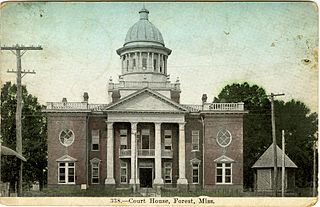
Forest is a city in Scott County, Mississippi. The population was 5,987 at the 2000 census. It is the county seat of Scott County and the population is a minority-majority.

Brookhaven is a small city in Lincoln County, Mississippi, United States, 60 miles south of the state capital of Jackson. The population was 12,520 at the 2010 U.S. Census. It is the county seat of Lincoln County. It was named after the Town of Brookhaven, New York by founder Samuel Jayne in 1818.

The Kaskaskia River is a tributary of the Mississippi River, approximately 325 miles (523 km) long, in central and southern Illinois in the United States. The second largest river system within Illinois, it drains a rural area of farms, as well as rolling hills along river bottoms of hardwood forests in its lower reaches. The lower reaches of the river have been canalized to allow barge traffic.

Lorman is an unincorporated community located in Jefferson County, Mississippi, United States. Lorman is approximately 8 miles (13 km) north of Fayette, near Highway 61 on Mississippi Highway 552.
Nesbit is an unincorporated community in DeSoto County, Mississippi, United States. Nesbit is approximately 7 miles (11 km) south of Horn Lake, approximately 9 miles (14 km) south of Southaven and approximately 5 miles (8.0 km) north of Hernando near U.S. Route 51 and Interstate 55. Legendary rock and roll pianist Jerry Lee Lewis has resided at and maintained a ranch in Nesbit since the mid-1970s.
Kevin Sessums is an American author, editor and actor.
Perthshire is an unincorporated community located in Bolivar County, Mississippi, United States along Mississippi Highway 1. Perthshire is approximately 5 miles (8.0 km) south of Deeson and approximately 3 miles (4.8 km) north of Gunnison.

Joey Kim Sessums is an American artist and physician, best known for his sculptures. Sessums resides in Brookhaven, Mississippi.

Lamont is an unincorporated community located in southern Bolivar County, Mississippi, United States on Mississippi Highway 1 on the Bolivar County/Washington County border. Lamont is approximately 4 miles (6.4 km) north of Winterville and approximately 5 miles (8.0 km) south of Scott.

Scott is an unincorporated community located in Bolivar County, Mississippi, United States on Mississippi Highway 1. Scott is approximately 5 miles (8.0 km) north of Lamont and approximately 7 miles (11 km) south of Benoit.
Skene is an unincorporated community located in Bolivar County, Mississippi, United States on Mississippi Highway 446. Skene is approximately 3 miles (4.8 km) west of Boyle and approximately 7 miles (11 km) north of Shaw.

Litton is an unincorporated community located in Bolivar County, Mississippi. Litton is approximately 10 miles (16 km) east of Benoit and approximately 7 miles (11 km) north of Shaw.
Enid is an unincorporated community located in Tallahatchie County, Mississippi, United States. Enid is located near U.S. Highway 51 approximately 7 miles (11 km) north of Oakland, Mississippi and approximately 9 miles (14 km) south of Pope, Mississippi.

Steiner is an unincorporated community located in Sunflower County, Mississippi. Steiner is located on Mississippi Highway 442 and is approximately 2.5 miles (4.0 km) north of Roundaway and approximately 3 miles (4.8 km) south of Linn.

Choctaw is an unincorporated community located in Bolivar County, Mississippi, United States. Choctaw is approximately 4 miles (6.4 km) south of Shaw and approximately 12 miles (19 km) east of Stringtown on Mississippi Highway 450.

Hushpuckena is an unincorporated community located in Bolivar County, Mississippi, United States along U.S. Route 61. Hushpuckena is approximately 3 miles (4.8 km) south of Duncan and approximately 4 miles (6.4 km) north of Shelby.
Deeson is an unincorporated community located in Bolivar County, Mississippi, United States along Mississippi Highway 1. Deeson is approximately 11 miles (18 km) south of Rena Lara and approximately 8 miles (13 km) north of Gunnison.
Round Lake is an unincorporated community located in Bolivar County, Mississippi, United States along Mississippi Highway 1. Round Lake is approximately 7 miles (11 km) west of Duncan and approximately 2 miles (3.2 km) north of Deeson.


