The Apex Park and Recreation District is a park and recreation district located in the northeastern portion of Jefferson County, Colorado, United States. Apex encompasses the portion of City of Arvada and adjacent areas that are located within Jefferson County. The district serves a population of more than 100,000. The district is a resource for all types of athletic activities, events, classes, and family entertainment for those who live in the encompassing neighborhoods, as well as visitors from across the metro area and beyond. With a few exceptions, the Apex Park and Recreation District boundaries are Sheridan Boulevard on the east, Clear Creek and 52nd Avenue on the south, Highway 93 on the west and the Boulder/Broomfield county line on the north.
Apex Park and Recreation District is managed by an executive director and a five-member elected board of directors. Directors serve four-year terms with elections held every two years in May.
While the Apex Park and Recreation District works collaboratively with other entities, it is a separate agency not connected to other government agencies.
Douglas County is a county located in the U.S. state of Colorado. As of the 2020 census, the population was 357,978. The county seat is Castle Rock.
Adams County is a county located in the U.S. state of Colorado. As of the 2020 census, the population was 519,572. The county seat is Brighton. The county is named for Alva Adams, an early Governor of the State of Colorado in 1887–1889. Adams County is part of the Denver–Aurora–Lakewood, CO Metropolitan Statistical Area.
Jefferson County is a county located in the U.S. state of Colorado. As of the 2020 census, the population was 582,910, making it the fourth-most populous county in Colorado. The county seat is Golden, and the most populous city is Lakewood.
Clear Creek County is a county located in the U.S. state of Colorado. As of the 2020 census, the population was 9,397. The county seat is Georgetown.
Arvada is a home rule municipality located in Jefferson and Adams counties, Colorado, United States. The city population was 124,402 at the 2020 United States Census, with 121,510 residing in Jefferson County and 2,892 residing in Adams County. Arvada is the seventh most populous city in Colorado. The city is a part of the Denver–Aurora–Lakewood, CO Metropolitan Statistical Area and the Front Range Urban Corridor. The Olde Town Arvada historic district is 7 miles (11 km) northwest of the Colorado State Capitol in Denver.
Broomfield is a consolidated city and county located in the U.S. state of Colorado. Broomfield has a consolidated government which operates under Article XX, Sections 10-13 of the Constitution of the State of Colorado. The Broomfield population was 74,112 at the 2020 United States Census, making it the 15th most populous municipality and the 12th most populous county in Colorado. Broomfield is a part of the Denver–Aurora–Lakewood, CO Metropolitan Statistical Area and the Front Range Urban Corridor.
The City of Westminster is a home rule municipality located in Adams and Jefferson counties, Colorado, United States. The city population was 116,317 at the 2020 United States Census with 71,240 residing in Adams County and 45,077 residing in Jefferson County. Westminster is the eighth most populous city in Colorado. The city is a part of the Denver–Aurora–Lakewood, CO Metropolitan Statistical Area and the Front Range Urban Corridor. The Westminster Municipal Center is located 9 miles (14 km) north-northwest of the Colorado State Capitol in Denver.
Superior is a statutory town in Boulder County, Colorado, United States, with a small, uninhabited segment of land area extending into Jefferson County. According to the 2020 census, the population of the city was 13,094.
Evergreen is an unincorporated town, a post office, and a census-designated place (CDP) located in and governed by Jefferson County, Colorado, U.S. The CDP is a part of the Denver–Aurora–Lakewood, CO Metropolitan Statistical Area. The Evergreen post office has the ZIP Codes 80439 and 80437. At the United States Census 2020, the population of the Evergreen CDP was 9,307. The Evergreen Metropolitan District provides services.
The Town of Lakeside is a Statutory Town in Jefferson County, Colorado, United States. The town population was 8 at the 2010 United States Census, making Lakeside the least populous municipality in the State of Colorado. Lakeside is immediately west of the City and County of Denver, the most populous municipality in the state. The Denver Post Office serves Lakeside.
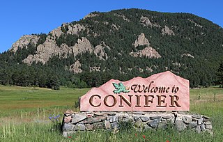
Conifer is an unincorporated community in Jefferson County, Colorado, United States. Conifer is located along U.S. Route 285 in the foothills west of Denver.
Colorado's 2nd congressional district is a congressional district in the U.S. state of Colorado. The district is located in the north-central part of the state and encompasses the northwestern suburbs of Denver including Boulder, Broomfield and much of western Jefferson County. The district also includes the mountain towns of Vail, Grand Lake and Idaho Springs. Redistricting in 2011 moved Larimer County, including the cities of Fort Collins and Loveland, to the 2nd from the 4th district for the 2012 election.
State Highway 470 is a state highway located in the southwestern portion of the Denver Metro Area. It is also the southwestern portion of the Denver Metro area's beltway. SH 470 begins at US 6 in Golden and heads south interchanging Interstate 70 and then US 285 outside Morrison. After leaving Morrison, it then heads east passing by Littleton and through Highlands Ranch before interchanging Interstate 25 in Lone Tree, where the freeway continues as a tollway and where the state highway designation ends.
Colorado's 6th congressional district is a congressional district in the U.S. state of Colorado. Located in central Colorado, the district encompasses much of the eastern part of the Denver metropolitan area, including all of Aurora, as well as portions of the southern and northern metro area.
Colorado's 7th congressional district is a congressional district in the U.S. state of Colorado. Formerly located only in the northeast part of the state, the district now encompasses the western parts of the Denver metropolitan area, including Golden, Lakewood, Arvada and Broomfield, along with the central Colorado counties of Jefferson, Park, Teller, Lake, Chaffee, Fremont, and Custer.
The North Central Colorado Urban Area comprises the four contiguous metropolitan statistical areas in the north central region of the State of Colorado: the Denver–Aurora Metropolitan Statistical Area, the Boulder Metropolitan Statistical Area, the Fort Collins-Loveland Metropolitan Statistical Area, and the Greeley Metropolitan Statistical Area. With the exception of southeastern Elbert County, southeastern Park County, and tiny portions of southern Douglas County, the entire North Central Colorado Urban Area is drained by the South Platte River and its tributaries. The North Central Colorado Urban Area is the central, and the most populous, of the three primary subregions of the Front Range Urban Corridor.
Jefferson County was a county of the extralegal United States Territory of Jefferson that existed from November 28, 1859, until February 28, 1861. Its territory covered a broad swath surrounding the region of the Pike's Peak Gold Rush, and was a functioning democratically elected government until the organization of the Territory of Colorado in 1861. At that time, the successor Jefferson County was permanently created, taking its name from its predecessor and incorporating the heart of its territory.
The Lariat Loop National Scenic and Historic Byway is a National Scenic Byway and a Colorado Scenic and Historic Byway located in Jefferson County, Colorado, USA. The byway is a 40-mile (64 km) loop in the Front Range foothills west of Denver through Golden, Lookout Mountain Park, Genesee Park, Evergreen, Morrison, Red Rocks Park, and Dinosaur Ridge. The Lariat Loop connects to the Mount Evans Scenic Byway at Bergen Park.
Hackberry Hill is a hill in northeast Arvada, Colorado between the Ralston Creek and Little Dry Creek watersheds.
The Front Range Urban Corridor is an oblong region of urban population located along the eastern face of the Southern Rocky Mountains, encompassing 18 counties in the US states of Colorado and Wyoming. The corridor derives its name from the Front Range, the mountain range that defines the western boundary of the corridor which serves as a gateway to the Rocky Mountains. The region comprises the northern portion of the Southern Rocky Mountain Front geographic area, which in turn comprises the southern portion of the Rocky Mountain Front geographic area of Canada and the United States. The Front Range Urban Corridor had a population of 5,055,344 at the 2020 Census, an increase of +16.65% since the 2010 Census.
This page is based on this Wikipedia article Text is available under the CC BY-SA 4.0 license; additional terms may apply. Images, videos and audio are available under their respective licenses.