Concrete, Colorado

Last updated
Concrete, Colorado
Usa edcp location map.svg
Red pog.svg
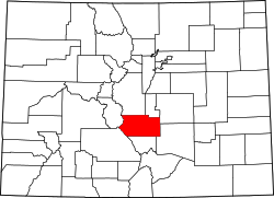
Concrete
Location of Concrete, Colorado.
USA Colorado location map.svg
Red pog.svg
Concrete
Concrete (Colorado)
Coordinates: 38°23′00″N104°59′52″W / 38.3833°N 104.9978°W / 38.3833; -104.9978 (Concrete, Colorado) [1]
Country United States
State Colorado
County Fremont [2]
Government
  Type unincorporated community
  Body Fremont County [2]
Elevation
[1]
5,036 ft (1,535 m)
Time zone UTC−07:00 (MST)
  Summer (DST) UTC−06:00 (MDT)
ZIP code [3]
(Penrose) 81240
Area codes 719
GNIS place ID 193883

Concrete [1] was one of three factory towns around the present-day Holcim plant in eastern Fremont County, Colorado, United States. The other two are Portland and Cement. All three are located south of Penrose, Colorado, and east of Florence, Colorado, along State Highway 120.

Contents

History

The town was founded in 1905. [4] The Concrete, Colorado, post office operated from May 28, 1908, until May 31, 1921. [5] The Penrose, Colorado, post office (ZIP code 81240) now serves the area. [3]

Geography

Concrete is located in Fremont County at coordinates 38°23′00″N104°59′52″W / 38.3833°N 104.9978°W / 38.3833; -104.9978 (Concrete, Colorado) and elevation 5,036 feet (1,535 m). [1]

See also

References

  1. 1 2 3 4 "Concrete, Colorado". Geographic Names Information System . United States Geological Survey, United States Department of the Interior . Retrieved July 26, 2025.
  2. 1 2 "Colorado Counties". Colorado Department of Local Affairs . Retrieved July 26, 2025.
  3. 1 2 "ZIP Code Lookup". United States Postal Service . Retrieved July 26, 2025.
  4. "Back In Time: Fremont County's Portland once a booming industrial town". Canon City Daily Record. Retrieved 2020-12-13.
  5. Bauer, William H.; Ozment, James L.; Willard, John H. (1990). Colorado Post Offices 1859–1989. Golden, Colorado: Colorado Railroad Historical Foundation. ISBN   0-918654-42-4.