Eldridge, California

Last updated

Eldridge
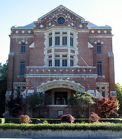
Sonoma State Home, Main Building, 15000 Arnold Dr., Eldridge, CA 6-12-2010 6-03-39 PM.JPG
Sonoma County California Incorporated and Unincorporated areas Eldridge Highlighted.svg
Location in Sonoma County and the state of California
Coordinates: 38°20′31″N122°30′43″W / 38.34194°N 122.51194°W / 38.34194; -122.51194
Country Flag of the United States (23px).png  United States
State Flag of California.svg  California
County Sonoma
Area
[1]
  Total
0.652 sq mi (1.689 km2)
  Land0.652 sq mi (1.689 km2)
  Water0 sq mi (0 km2)  0%
Elevation
[2]
177 ft (54 m)
Population
 (2010)
  Total
1,233
  Density1,900/sq mi (730/km2)
Time zone UTC-8 (PST)
  Summer (DST) UTC-7 (PDT)
ZIP code
95431
Area code 707
FIPS code 06-21894
GNIS feature ID1701268

Eldridge is a census-designated place (CDP) in Sonoma County, California, United States. The population was 1,233 at the 2010 census. It is notably the home to the Sonoma Developmental Center, the largest facility serving the needs of persons with developmental disabilities in the state.

Contents

History

Eldridge is named for James Eldridge who owned part of the Rancho Cabeza de Santa Rosa land grant. [3]

Geography

According to the United States Census Bureau, the CDP has a total area of 0.7 square miles (1.8 km2), all of it land.

Demographics

Historical population
CensusPop.Note
U.S. Decennial Census [4]

2010

The 2010 United States Census [5] reported that Eldridge had a population of 1,233. The population density was 1,891.1 inhabitants per square mile (730.2/km2). The racial makeup of Eldridge was 988 (80.1%) White, 10 (0.8%) African American, 3 (0.2%) Native American, 36 (2.9%) Asian, 6 (0.5%) Pacific Islander, 144 (11.7%) from other races, and 46 (3.7%) from two or more races. Hispanic or Latino of any race were 325 persons (26.4%).

The Census reported that 99.8% of the population lived in households and 0.2% lived in non-institutionalized group quarters.

There were 500 households, out of which 155 (31.0%) had children under the age of 18 living in them, 242 (48.4%) were opposite-sex married couples living together, 46 (9.2%) had a female householder with no husband present, 28 (5.6%) had a male householder with no wife present. There were 35 (7.0%) unmarried opposite-sex partnerships, and 5 (1.0%) same-sex married couples or partnerships. 137 households (27.4%) were made up of individuals, and 33 (6.6%) had someone living alone who was 65 years of age or older. The average household size was 2.46. There were 316 families (63.2% of all households); the average family size was 3.02.

The population was spread out, with 274 people (22.2%) under the age of 18, 109 people (8.8%) aged 18 to 24, 320 people (26.0%) aged 25 to 44, 394 people (32.0%) aged 45 to 64, and 136 people (11.0%) who were 65 years of age or older. The median age was 39.8 years. For every 100 females, there were 100.8 males. For every 100 females age 18 and over, there were 99.0 males.

There were 563 housing units at an average density of 863.5 per square mile (333.4/km2), of which 53.4% were owner-occupied and 46.6% were occupied by renters. The homeowner vacancy rate was 2.2%; the rental vacancy rate was 12.4%. 54.5% of the population lived in owner-occupied housing units and 45.3% lived in rental housing units.
2000

As of the census [6] of 2000, there were 1,534 people, 521 households, and 321 families residing in the CDP. The population density was 2,403.1 inhabitants per square mile (927.8/km2). There were 551 housing units at an average density of 863.2 per square mile (333.3/km2). The racial makeup of the CDP was 85.92% White, 1.96% African American, 0.78% Native American, 2.80% Asian, 0.20% Pacific Islander, 4.04% from other races, and 4.30% from two or more races. Hispanic or Latino of any race were 13.95% of the population.

There were 521 households, out of which 35.9% had children under the age of 18 living with them, 46.3% were married couples living together, 10.4% had a female householder with no husband present, and 38.2% were non-families. 30.3% of all households were made up of individuals, and 5.8% had someone living alone who was 65 years of age or older. The average household size was 2.44 and the average family size was 3.10.

In the CDP, the population was spread out, with 22.7% under the age of 18, 6.3% from 18 to 24, 35.5% from 25 to 44, 29.1% from 45 to 64, and 6.3% who were 65 years of age or older. The median age was 38 years. For every 100 females, there were 99.7 males. For every 100 females age 18 and over, there were 94.4 males.

The median income for a household in the CDP was $52,656, and the median income for a family was $62,500. Males had a median income of $35,426 versus $34,886 for females. The per capita income for the CDP was $24,076. None of the families and 16.3% of the population were living below the poverty line, including no under eighteens and 11.8% of those over 64.

Government

In the California State Legislature, Eldridge is in the 2nd Senate District , represented by Democrat Mike McGuire, and in the 4th Assembly District , represented by Democrat Cecilia Aguiar-Curry. [7]

In the United States House of Representatives, Eldridge is in California's 5th congressional district , represented by Republican Tom McClintock. [8]

Education

The school district is Sonoma Valley Unified School District. [9]

See also

  1. U.S. Census Archived 2012-01-25 at the Wayback Machine
  2. "US Gazetteer files: 2010, 2000, and 1990". United States Census Bureau. February 12, 2011. Retrieved April 23, 2011.
  3. Erwin G. Gudde, William Bright, 2004,California Place Names,University of California Press, ISBN   978-0-520-24217-3
  4. "Census of Population and Housing". Census.gov. Retrieved June 4, 2016.
  5. "2010 Census Interactive Population Search: CA - Eldridge CDP". U.S. Census Bureau. Archived from the original on July 15, 2014. Retrieved July 12, 2014.
  6. "U.S. Census website". United States Census Bureau . Retrieved January 31, 2008.
  7. "Statewide Database". UC Regents. Retrieved December 5, 2014.
  8. "California's 5th Congressional District - Representatives & District Map". Civic Impulse, LLC. Retrieved March 8, 2013.
  9. "2020 CENSUS - SCHOOL DISTRICT REFERENCE MAP: Sonoma County, CA" (PDF). U.S. Census Bureau . Retrieved December 7, 2024. - Text list

Related Research Articles

<span class="mw-page-title-main">Raisin City, California</span> Census-designated place in California, United States

Raisin City is a census-designated place (CDP) in Fresno County, California, United States. The population was 380 at the 2010 census, up from 165 at the 2000 census. Raisin City is located 13 miles (21 km) south-southwest of downtown Fresno, at an elevation of 236 feet.

<span class="mw-page-title-main">Westhaven-Moonstone, California</span> Census-designated place in California, United States

Westhaven-Moonstone is a census-designated place (CDP) located in Humboldt County, California, United States. As of the 2010 census the population was 1,205, up from 1,044 at the 2000 census.

<span class="mw-page-title-main">Tomales, California</span> Census-designated place in California, United States

Tomales is a census-designated place (CDP) on State Route 1 in Marin County, California, United States. The population was 187 at the 2020 census.

<span class="mw-page-title-main">Winchester, California</span> Census-designated place in California, United States

Winchester is a census-designated place (CDP) in Riverside County, California, USA. As of the 2010 census, the CDP had a total population of 2,534, up from 2,155 at the 2000 census.

<span class="mw-page-title-main">Green Valley, Solano County, California</span> Census-designated place in California, United States

Green Valley is a census-designated place (CDP) located in Solano County, California, United States. It sits in the northeast corner of the San Francisco Bay Area and is located approximately 45 miles (72 km) from Sacramento, approximately 38 miles (61 km) from San Francisco, approximately 32 miles (51 km) from Oakland, less than 15 miles (24 km) from Napa Valley, and less than 15 miles (24 km) from both the Carquinez Bridge and the Benicia Bridge.

<span class="mw-page-title-main">Boyes Hot Springs, California</span> Census designated place in California, United States

Boyes Hot Springs is a census-designated place (CDP) in Sonoma Valley, Sonoma County, California, United States. The population was 6,656 people at the 2010 census. Resorts in Boyes Hot Springs, El Verano, Fetters Hot Springs, and Agua Caliente were popular health retreats for tourists from San Francisco and points beyond until the middle of the 20th century because of the geothermic hot springs that still well up from deep within the Earth.

<span class="mw-page-title-main">El Verano, California</span> Census-designated place in California, United States

El Verano is a census-designated place (CDP) in Sonoma Valley, Sonoma County, California, United States. The population was 4,123 at the 2010 census, falling to 3,867 at the 2020 census.

<span class="mw-page-title-main">Fetters Hot Springs-Agua Caliente, California</span> Census-designated place in California, United States

Fetters Hot Springs-Agua Caliente is a census-designated place (CDP) in Sonoma Valley, Sonoma County, California, in the United States. As of the 2010 census, the CDP population was 4,144. The name Agua Caliente translates into English, from Spanish, as hot water, referring to the hot springs historically found in the area.

<span class="mw-page-title-main">Forestville, California</span> Census-designated place in California, United States

Forestville is a census-designated place (CDP) in Sonoma County, California, United States. It was settled during the late 1860s and was originally spelled Forrestville after one of its founders. The spelling long ago became standardized with one "r". The population was 3,293 at the 2010 census, an increase of nearly 1,000 since the 2000 census.

<span class="mw-page-title-main">Glen Ellen, California</span> Census designated place in California, United States

Glen Ellen is a census-designated place (CDP) in Sonoma Valley, Sonoma County, California, United States. The population was 784 at the 2010 census, down from 992 at the 2000 census. Glen Ellen is the location of Jack London State Historic Park, Sonoma Valley Regional Park, and a former home of Hunter S. Thompson.

<span class="mw-page-title-main">Graton, California</span> Census-designated place in California, United States

Graton is an unincorporated town and census-designated place (CDP) in west Sonoma County, California, United States. The population was 1,707 at the 2010 census. Graton's ZIP code is 95444. The town also has a culinary reputation attributed to two restaurants in the area.

<span class="mw-page-title-main">Monte Rio, California</span> Census-designated place in California, United States

Monte Rio is a census-designated place (CDP) in Sonoma County, California along the Russian River near the Pacific Ocean. The town of Guerneville lies northeast of Monte Rio, and Jenner is to the west. The population was 1,152 at the 2010 census, up from 1,104 at the 2000 census. Bohemian Grove is located in Monte Rio.

<span class="mw-page-title-main">Occidental, California</span> Census-designated place in California, United States

Occidental is a census-designated place (CDP) in Sonoma County, California, United States. The population was 1,132 at the 2020 census, up from 1,115 at the 2010 census.

<span class="mw-page-title-main">Roseland, California</span> Place in California, United States

Roseland is a neighborhood in Santa Rosa, California. As of the 2010 census, the population was 6,325. Roseland was an unincorporated enclave within the City of Santa Rosa until the area was annexed by Santa Rosa on November 1, 2017.

<span class="mw-page-title-main">Temelec, California</span> Census-designated place in California, United States

Temelec is a census-designated place (CDP) in Sonoma County, California, United States. The population was 1,441 at the 2010 census.

<span class="mw-page-title-main">West Modesto, California</span> Census-designated place in California, United States

West Modesto is a census-designated place (CDP) in Stanislaus County, California, United States. The population was 5,682 at the 2010 census, down from 6,096 at the 2000 census. It is part of the Modesto Metropolitan Statistical Area.

<span class="mw-page-title-main">Salton Sea Beach, California</span> Census-designated place in California, United States

Salton Sea Beach is a census-designated place (CDP) in Imperial County, California, located 2.5 miles (4 km) southeast of Desert Shores. The population was 508 at the 2020 census, up from 422 at the 2010 census, up from 392 at the 2000 census. It is part of the El Centro, California Metropolitan Statistical Area. It was the location of the Naval Auxiliary Air Station Salton Sea.

<span class="mw-page-title-main">Larkfield-Wikiup, California</span> Census-designated place in California, United States

Larkfield-Wikiup is a census-designated place unincorporated area in Sonoma County, California, United States. The population was 8,884 at the 2010 census, up from 7,479 at the 2000 census. It comprises the Mark West area between Santa Rosa, Windsor (north), Calistoga (east), and Fulton (west). There are at least four schools within the limits of the CDP, including Cardinal Newman High School, John B. Riebli Elementary School, Mark West Elementary, and San Miguel Elementary schools.

<span class="mw-page-title-main">Fulton, California</span> Census-designated place in California, United States

Fulton is a census-designated place (CDP) in Sonoma County, California, United States. Fulton is just to the north of the city limits of Santa Rosa, and 7 miles (11 km) north-northeast of Sebastopol. Fulton has a post office, established in 1871 and assigned ZIP code 95439. The community is named after Thomas and James Fulton, who founded the community. The population as of the 2010 U.S. Census was 541. There are a set of railway lines which go through the town boundaries; these lines are used by Sonoma–Marin Area Rail Transit. Fulton was once home to a chicken processing plant that was in operation from the 1960s until its closure in 2010.

<span class="mw-page-title-main">Sereno del Mar, California</span> Census-designated place in California, United States

Sereno del Mar is a census-designated place (CDP) in Sonoma County, California. Sereno del Mar sits at an elevation of 190 feet (58 m). The 2020 United States census reported Sereno del Mar's population was 107.