Glen Dale, West Virginia

Last updated

Glen Dale, West Virginia
Flag of Glen Dale, West Virginia.png
Seal of Glen Dale, West Virginia.jpg
Motto: 
Montani Semper Liberi
Marshall County West Virginia Incorporated and Unincorporated areas Glen Dale Highlighted.svg
Location of Glen Dale in Marshall County, West Virginia.
Coordinates: 39°56′55″N80°45′18″W / 39.94861°N 80.75500°W / 39.94861; -80.75500
Country Flag of the United States.svg  United States
State Flag of West Virginia.svg  West Virginia
County Flag of Marshall County, West Virginia.svg Marshall
Area
[1]
  Total1.20 sq mi (3.11 km2)
  Land0.85 sq mi (2.20 km2)
  Water0.35 sq mi (0.91 km2)
Elevation
692 ft (211 m)
Population
 (2020) [2]
  Total1,514
  Estimate 
(2021) [2]
1,486
  Density1,612.94/sq mi (622.89/km2)
Time zone UTC-5 (Eastern (EST))
  Summer (DST) UTC-4 (EDT)
ZIP code
26038
Area code 304/681
FIPS code 54-31492 [3]
GNIS feature ID1560592 [4]
Website www.glendalewv.gov

Glen Dale is a city in Marshall County, West Virginia, United States, along the Ohio River. It is part of the Wheeling, West Virginia Metropolitan Statistical Area. The population was 1,514 at the 2020 census. [2] Glen Dale was incorporated in 1924. It is in the northwest part of the county, which is above the Mason–Dixon line and forms the base of the Northern Panhandle of West Virginia.

Contents

Geography

Glen Dale is located at 39°56′55″N80°45′18″W / 39.94861°N 80.75500°W / 39.94861; -80.75500 (39.948594, -80.754922). [5]

According to the United States Census Bureau, the city has a total area of 1.20 square miles (3.11 km2), of which 0.85 square miles (2.20 km2) is land and 0.35 square miles (0.91 km2) is water. [6]

Demographics

Historical population
CensusPop.Note
1930 1,493
1940 1,348−9.7%
1950 1,4678.8%
1960 1,90529.9%
1970 2,15012.9%
1980 1,875−12.8%
1990 1,612−14.0%
2000 1,552−3.7%
2010 1,526−1.7%
2020 1,514−0.8%
2021 (est.)1,486 [2] −1.8%
U.S. Decennial Census [7]

2010 census

As of the census [8] of 2010, there were 1,526 people, 688 households and 475 families living in the city. The population density was 1,795.3 inhabitants per square mile (693.2/km2). There were 745 housing units at an average density of 876.5 per square mile (338.4/km2). The racial makeup of the city was 97.5% White, 0.1% African American, 0.5% Native American, 0.4% Asian, 0.4% from other races, and 1.0% from two or more races. Hispanic or Latino of any race were 1.0% of the population.

There were 688 households, of which 23.1% had children under the age of 18 living with them, 52.6% were married couples living together, 11.6% had a female householder with no husband present, 4.8% had a male householder with no wife present, and 31.0% were non-families. 28.1% of all households were made up of individuals, and 14.5% had someone living alone who was 65 years of age or older. The average household size was 2.22 and the average family size was 2.65.

The median age in the city was 50 years. 17.1% of residents were under the age of 18; 6.7% were between the ages of 18 and 24; 19.3% were from 25 to 44; 33.8% were from 45 to 64; and 23.1% were 65 years of age or older. The gender makeup of the city was 46.9% male and 53.1% female.

2000 census

As of the census [3] of 2000, there were 1,552 people, 697 households and 469 families living in the city. The population density was 1,940.8 per square mile (749.0/km2). There were 757 housing units at an average density of 946.6 per square mile (365.3/km2). The racial makeup of the city was 98.65% White, 1.96% African American, 0.32% Asian, 0.26% from other races, and 0.71% from two or more races. Hispanic or Latino of any race were 0.08% of the population.

There were 697 households, of which 24.1% had children under the age of 18 living with them, 56.7% were married couples living together, 9.0% had a female householder with no husband present, and 32.6% were non-families. 30.4% of all households were made up of individuals, and 18.7% had someone living alone who was 65 years of age or older. The average household size was 2.23 and the average family size was 2.75.

In the town the population was spread out, with 19.3% under the age of 18, 5.9% from 18 to 24, 23.0% from 25 to 44, 28.1% from 45 to 64, and 23.7% who were 65 years of age or older. The median age was 46 years. For every 100 females, there were 87.7 males. For every 100 females age 18 and over, there were 83.6 males.

The median income for a household in the town was $40,000, and the median income for a family was $49,306. Males had a median income of $40,352 versus $25,588 for females. The per capita income for the city was $24,409. About 5.4% of families and 6.5% of the population were below the poverty line, including 6.9% of those under age 18 and 9.6% of those age 65 or over.

History

The community was named after Glendale, the farm of a local family. [9]

Notable people

Glen Dale is the home town of:

See also

Related Research Articles

<span class="mw-page-title-main">Wyoming County, West Virginia</span> County in West Virginia, United States

Wyoming County is a county in the U.S. state of West Virginia. As of the 2020 census, the population was 21,382. Its county seat is Pineville. The county was created in 1850 from Logan County and named for the Lenape word meaning "large plains".

<span class="mw-page-title-main">Lewis County, West Virginia</span> County in West Virginia, United States

Lewis County is a county in the U.S. state of West Virginia. As of the 2020 census, the population was 17,033. Its county seat is Weston. The county was formed in 1816 from Harrison County.

<span class="mw-page-title-main">Ladora, Iowa</span> City in Iowa, United States

Ladora is a city in Iowa County, Iowa, United States. The population was 229 at the time of the 2020 census.

<span class="mw-page-title-main">Cohoctah Township, Michigan</span> Civil township in Michigan, United States

Cohoctah Township is a civil township of Livingston County in the U.S. state of Michigan. The population was 3,317 at the 2010 census. It is located in the northwest quadrant of the county, bordered by Conway Township to the west, Deerfield Township to the east, and Howell Township to the south. To the north is Shiawassee County.

<span class="mw-page-title-main">Glen Lyn, Virginia</span> Town in Virginia, United States

Glen Lyn is a town in Giles County, Virginia, United States, at the confluence of the East and New rivers. The population was 115 at the 2010 census, down from 151 at the 2000 census. It is part of the Blacksburg–Christiansburg Metropolitan Statistical Area.

<span class="mw-page-title-main">Stanleytown, Virginia</span> CDP in Virginia, United States

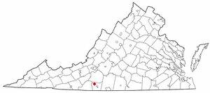
Stanleytown is a census-designated place (CDP) in Henry County, Virginia, United States. The population was 1,422 at the 2010 census. It is part of the Martinsville Micropolitan Statistical Area.

<span class="mw-page-title-main">Sylvester, West Virginia</span> Town in West Virginia, United States

Sylvester is a town in Boone County, West Virginia, United States, along the Big Coal River. The population was 166 at the 2020 census. Sylvester was incorporated on April 11, 1952 by the Boone County Circuit Court. Sylvester bears the name of a family of settlers.

<span class="mw-page-title-main">Follansbee, West Virginia</span> City in West Virginia, United States

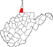
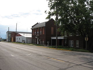
Follansbee is a city in Brooke County, West Virginia, United States, located along the Ohio River. The population was 2,853 at the 2020 census, a decrease from 2,986 at the 2010 census. It is part of the Weirton–Steubenville metropolitan area. The city was named after the Follansbee brothers, the proprietors of a local steel mill.

<span class="mw-page-title-main">Chester, West Virginia</span> City in West Virginia, United States

Chester is a city in northern Hancock County, West Virginia, United States, along the Ohio River. The population was 2,214 at the 2020 census. Located immediately south of Ohio and just west of Pennsylvania, Chester is the northernmost city in West Virginia. It is a part of the Weirton–Steubenville metropolitan area, and is home to the World's Largest Teapot.

<span class="mw-page-title-main">West Logan, West Virginia</span> Town in West Virginia, United States

West Logan is a town along the Guyandotte River in Logan County, West Virginia, United States. The population was 400 at the 2020 census. For unknown reasons, some sources report West Logan to lay west of the county seat at Logan, attributing to this fact the name.

<span class="mw-page-title-main">Worthington, West Virginia</span> Town in West Virginia, United States

Worthington is a town in Marion County, West Virginia, United States. The population was 158 at the 2010 census. Worthington was incorporated in 1893 and named for Colonel George Worthington, an early settler. U.S. Route 19 passes through the town.

<span class="mw-page-title-main">War, West Virginia</span> City in West Virginia, United States

War is a city in McDowell County, West Virginia, United States. The population was 690 at the 2020 census. War was incorporated in 1920 by the Circuit Court of McDowell County. Its name is derived from War Creek, whose confluence with Dry Fork is located within the city. War is the only place in the United States with this name. War was formerly known as Miner's City. It is also known for being a setting in the movie October Sky; as writer Homer Hickam's Big Creek High School.

<span class="mw-page-title-main">Belmont, West Virginia</span> Town in West Virginia, United States

Belmont is a town in Pleasants County, West Virginia, United States. It is part of the Parkersburg–Vienna metropolitan area. The population was 872 at the 2020 census. Belmont was incorporated on April 19, 1946 by the Circuit Court of Pleasants County. The city was named for the beautiful hills in the area.

<span class="mw-page-title-main">Brandonville, West Virginia</span> Town in West Virginia, United States

Brandonville is a town in northern Preston County, West Virginia, United States. The population was 136 at the 2020 census. It is part of the Morgantown metropolitan area.

<span class="mw-page-title-main">Lester, West Virginia</span> Town in West Virginia, United States

Lester is a town in Raleigh County, West Virginia, United States. The population was 337 at the 2020 census. The community was named after Champ Lester, a local pioneer.

<span class="mw-page-title-main">Harman, West Virginia</span> Town in West Virginia, United States

Harman is a town in Randolph County, West Virginia, United States. The population was 96 at the 2020 census.

<span class="mw-page-title-main">Ellenboro, West Virginia</span> Town in West Virginia, United States

Ellenboro is a town in Ritchie County, West Virginia, United States. The population was 222 at the 2020 census. The town is located at the junction of U.S. Route 50 and West Virginia Route 16; the North Bend Rail Trail also passes through the town. The town was named for Ellen Mariah Williamson, the eldest daughter of the family that granted a right of way for the Baltimore and Ohio Railroad to build their line through the town; an earlier name for the community was Shumley. Ellenboro was incorporated in 1903.

<span class="mw-page-title-main">Pennsboro, West Virginia</span> City in West Virginia, United States

Pennsboro is a city in Ritchie County, West Virginia, United States. The population was 1,050 at the 2020 census. The city is located at the junction of U.S. Route 50 and West Virginia Route 74; the North Bend Rail Trail also passes through the city.

<span class="mw-page-title-main">Camden-on-Gauley, West Virginia</span> Town in West Virginia, United States

Camden-on-Gauley is a town in Webster County, West Virginia, United States, along the Gauley River. The population was 126 at the 2020 census.

<span class="mw-page-title-main">Pineville, West Virginia</span> Town in West Virginia, United States

Pineville is a town in and the county seat of Wyoming County, West Virginia, United States, situated along the Guyandotte River. The population was 648 at the 2020 census.

References

  1. "2019 U.S. Gazetteer Files". United States Census Bureau. Retrieved August 7, 2020.
  2. 1 2 3 4 "City and Town Population Totals: 2020-2021". Census.gov. US Census Bureau. Retrieved July 2, 2022.
  3. 1 2 "U.S. Census website". United States Census Bureau . Retrieved January 31, 2008.
  4. "US Board on Geographic Names". United States Geological Survey. October 25, 2007. Retrieved January 31, 2008.
  5. "US Gazetteer files: 2010, 2000, and 1990". United States Census Bureau. February 12, 2011. Retrieved April 23, 2011.
  6. "US Gazetteer files 2010". United States Census Bureau. Archived from the original on January 12, 2012. Retrieved January 24, 2013.
  7. "Census of Population and Housing". Census.gov. Retrieved June 4, 2015.
  8. "U.S. Census website". United States Census Bureau . Retrieved January 24, 2013.
  9. Kenny, Hamill (1945). West Virginia Place Names: Their Origin and Meaning, Including the Nomenclature of the Streams and Mountains. Piedmont, WV: The Place Name Press. p. 272.
  10. Lac, J. Freedom du (October 6, 2007). "Small-Town Inspiration". The Washington Post . ISSN   0190-8286 . Retrieved September 12, 2017.
  11. 1 2 "Shelley Moore". The Intelligencer & Wheeling News Register . September 14, 2014. Retrieved September 14, 2014.