List of census-designated places in Oregon by population

Last updated
Map of the United States with Oregon highlighted Oregon in United States.svg
Map of the United States with Oregon highlighted

Oregon is a state located in the Western United States that is divided into 36 counties and contains 135 census designated-places (CDPs) [1] . All population data is based on the 2010 census.

Oregon State of the United States of America

Oregon is a state in the Pacific Northwest region on the West Coast of the United States. The Columbia River delineates much of Oregon's northern boundary with Washington, while the Snake River delineates much of its eastern boundary with Idaho. The parallel 42° north delineates the southern boundary with California and Nevada. Oregon is one of only three states of the contiguous United States to have a coastline on the Pacific Ocean.

U.S. state constituent political entity of the United States

In the United States, a state is a constituent political entity, of which there are currently 50. Bound together in a political union, each state holds governmental jurisdiction over a separate and defined geographic territory and shares its sovereignty with the federal government. Due to this shared sovereignty, Americans are citizens both of the federal republic and of the state in which they reside. State citizenship and residency are flexible, and no government approval is required to move between states, except for persons restricted by certain types of court orders. Four states use the term commonwealth rather than state in their full official names.

Western United States Region in the United States

The Western United States is the region comprising the westernmost states of the United States. As European settlement in the U.S. expanded westward through the centuries, the meaning of the term the West changed. Before about 1800, the crest of the Appalachian Mountains was seen as the western frontier. The frontier moved westward and eventually the lands west of the Mississippi River were considered the West.

Contents

Census-Designated Places

Aloha Aloha Oregon tv hwy.JPG
Aloha
Oak Hills Oak Hills Historic District sign.jpg
Oak Hills
Green Green, Oregon.jpg
Green
Brightwood is one of the communities in Mount Hood Village Brightwood.jpg
Brightwood is one of the communities in Mount Hood Village
Market in Rose Lodge Rose Lodge Oregon Store.jpg
Market in Rose Lodge
Baptist church in Stafford Stafford Oregon Baptist church.JPG
Baptist church in Stafford
Pacific City Aerial View of Pacific City, Oregon.JPG
Pacific City
Trail Trail Oregon.jpg
Trail
Pine Hollow Pine Hollow, Oregon.jpg
Pine Hollow
Umpqua River Light in Winchester Bay Umpqua River lighthouse.jpg
Umpqua River Light in Winchester Bay
Crawfordsville Bridge in Crawfordsville Crawfordsville OR - covered bridge.jpg
Crawfordsville Bridge in Crawfordsville
General store in Days Creek General Store in Days Creek, Oregon.jpg
General store in Days Creek
Porter-Brasfield House in Shedd Porter-Brasfield House Shedd.jpg
Porter-Brasfield House in Shedd
Market in Alpine Alpine OR.JPG
Market in Alpine
Beaver Beaver, Oregon.jpg
Beaver
Pistol River Pistol River mouth, Pacific Ocean.jpg
Pistol River
Plush Plush, Oregon.jpg
Plush
Name County Population (2010) [1] Land area [1]
sq mikm2
Aloha Washington 49,4257.3719.1
Bethany Washington 20,6465.1413.3
Hayesville Marion 19,9363.078.0
Altamont Klamath 19,2578.1021.0
Oak Grove Clackamas 16,6293.8910.1
Four Corners Marion 15,9472.707.0
Cedar Mill Multnomah and Washington 14,5463.328.6
Oatfield Clackamas 13,4153.408.8
Oak Hills Washington 11,3331.564.0
Rockcreek Washington 9,3161.965.1
Bull Mountain Washington 9,1332.917.5
Cedar Hills Washington 8,3001.914.9
West Haven-Sylvan Multnomah and Washington 8,0012.336.0
White City Jackson 7,9751.874.8
Green Douglas 7,5154.5311.7
Jennings Lodge Clackamas 7,3151.604.1
Garden Home-Whitford Washington 6,6741.523.9
West Slope Washington 6,5541.624.2
Roseburg North Douglas 5,91222.3357.8
Raleigh Hills Washington 5,8961.534.0
Deschutes River Woods Deschutes 5,0775.9615.4
Mount Hood Village Clackamas 4,86426.1467.7
Beavercreek Clackamas 4,48520.1252.1
Tri-City Douglas 3,9317.2218.7
Metzger Washington 3,7650.741.9
Three Rivers Deschutes 3,0147.5319.5
Warm Springs Jefferson 2,94542.52110.1
Redwood Josephine 2,6273.479.0
Harbor Curry 2,3911.925.0
Odell Hood River 2,2552.025.2
Mulino Clackamas 2,10313.7835.7
Lincoln Beach Lincoln 2,0453.238.4
Rose Lodge Lincoln 1,8949.5424.7
Chenoweth Wasco 1,8555.6114.5
Barview Coos 1,8441.383.6
Glide Douglas 1,79510.0826.1
Warren Columbia 1,7876.3016.3
Eagle Crest Deschutes 1,69615.1939.3
Grand Ronde Polk and Yamhill 1,6610.701.8
Merlin Josephine 1,61519.2049.7
Stafford Clackamas 1,5776.0215.6
New Hope Josephine 1,5153.839.9
Bunker Hill Coos 1,4441.463.8
Sunriver Deschutes 1,3938.8322.9
Terrebonne Deschutes 1,2571.012.6
Fruitdale Josephine 1,1770.481.2
Williams Josephine 1,07211.3229.3
Mission Umatilla 1,0377.6119.7
Pacific City Tillamook 1,0353.729.6
South Lebanon Linn 1,0051.042.7
Bayside Gardens Tillamook 8800.992.6
Lookingglass Douglas 85511.5830.0
Ruch Jackson 8406.7317.4
Foots Creek Jackson 7996.0715.7
Glasgow Coos 7633.228.3
Netarts Tillamook 7482.606.7
Melrose Douglas 7354.3511.3
Trail Jackson 7026.8017.6
Selma Josephine 6956.4616.7
Wimer Jackson 6784.9612.8
Kerby Josephine 5952.586.7
Lacomb Linn 5463.9810.3
O'Brien Josephine 5045.2113.5
Pine Hollow Wasco 4942.225.7
Tumalo Deschutes 4881.714.4
Tutuilla Umatilla 48720.0551.9
Dillard Douglas 4781.183.1
Nesika Beach Curry 4632.285.9
Prospect Jackson 4553.509.1
Labish Village Marion 4120.050.13
Brooks Marion 3980.521.3
Crabtree Linn 3911.814.7
Winchester Bay Douglas 3822.316.0
Gopher Flats Umatilla 3792.115.5
Holley Linn 3782.827.3
Takilma Josephine 3785.9415.4
Jeffers Gardens Clatsop 3680.571.5
Black Butte Ranch Deschutes 3668.2021.2
Oceanside Tillamook 3611.042.7
Idaville Tillamook 3370.491.3
Crawfordsville Linn 3321.925.0
Westport Clatsop 3210.661.7
Umapine Umatilla 3153.328.6
Marion Marion 3131.153.0
Parkdale Hood River 3110.631.6
Deer Island Columbia 2940.491.3
Mehama Marion 2920.461.2
Mount Hood Hood River 2861.925.0
Fair Oaks Douglas 2781.844.8
Days Creek Douglas 2722.366.1
Butteville Marion 2651.052.7
Cloverdale Tillamook 2500.802.1
Gardiner Douglas 2480.581.5
Annex Malheur 2352.466.4
Camp Sherman Jefferson 2333.158.2
Hebo Tillamook 2321.634.2
Tygh Valley Wasco 2063.739.7
Shedd Linn 2041.513.9
Riverside Umatilla 1990.601.6
Government Camp Clackamas 1930.751.9
Neahkahnie Tillamook 1920.651.7
Rowena Wasco 1871.814.7
Seventh Mountain Deschutes 1871.955.1
Kirkpatrick Umatilla 1793.579.2
Langlois Curry 1771.433.7
Alpine Benton 1710.812.1
Alsea Benton 1640.150.39
Silver Lake Lake 1491.483.8
Pine Grove Wasco 1486.0315.6
Cascadia Linn 1475.0213.0
Neskowin Tillamook 1341.393.6
Crane Harney 12910.4227.0
Fort Hill Polk and Yamhill 1291.453.8
Beaver Tillamook 1220.391.0
New Pine Creek Lake 1202.476.4
West Scio Linn 1200.340.88
Harper Malheur 1097.0018.1
Cape Meares Tillamook 992.516.5
Peoria Linn 940.471.2
Brogan Malheur 902.867.4
Wamic Wasco 851.213.1
Pistol River Curry 840.591.5
Summit Benton 820.310.80
Rickreall Polk 770.170.44
Bellfountain Benton 751.303.4
Cayuse Umatilla 682.887.5
Kings Valley Benton 650.691.8
Wallowa Lake Wallowa 621.834.7
Blodgett Benton 580.561.5
Juntura Malheur 572.295.9
Plush Lake 571.624.2
Eola Polk 450.050.13
Tetherow Deschutes 452.115.5
Pronghorn Deschutes 346.6017.1
Biggs Junction Sherman 220.852.2

See also

Related Research Articles

Yamhill County, Oregon County in the United States

Yamhill County is a county in the U.S. state of Oregon. As of the 2010 census, the population was 99,193. The county seat is McMinnville. The name's origin is probably an explorer's name for a local Native American tribe, the Yamhill, who are part of the North Kalapuyan family.

Wheeler County, Oregon County in the United States

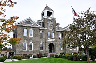
Wheeler County is a county in the U.S. state of Oregon. As of the 2010 census, the population was 1,441, making it Oregon's least populous county. The county seat is Fossil. It is named in honor of Henry H. Wheeler, an early settler who owned a farm near Mitchell.

Wallowa County, Oregon County in the United States

Wallowa County is a county in the U.S. state of Oregon. As of the 2010 census, the population was 7,008, making it Oregon's fourth-least populous county. Its county seat is Enterprise. According to Oregon Geographic Names, the origins of the county's name are uncertain, with the most likely explanation being it is derived from the Nez Perce term for a structure of stakes used in fishing. An alternative explanation is that Wallowa is derived from a Nez Perce word for "winding water". The journals of Lewis and Clark Expedition record the name of the Wallowa River as Wil-le-wah.

Polk County, Oregon County in the United States

Polk County is a county located in the U.S. state of Oregon. As of the 2010 census, the population was 75,403, making it the least populous county in the Willamette Valley. The county seat is Dallas. The county is named for James Knox Polk, the 11th president of the United States.

Multnomah County, Oregon County in the United States

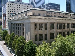
Multnomah County is one of 36 counties in the U.S. state of Oregon. As of the 2010 United States Census, the county's population was 735,334. Its county seat, Portland, is the state's largest city. Multnomah County is part of the Portland-Vancouver-Hillsboro, OR-WA Metropolitan Statistical Area, and though smallest in area, it is the state's most populous county.

Marion County, Oregon County in the United States

Marion County is a county located in the U.S. state of Oregon. The population was 315,335 at the 2010 census, making it the fifth-most populous county in Oregon. The county seat is Salem, the state capital. The county was originally named the Champooick District, after Champoeg, a meeting place on the Willamette River. On September 3, 1849, the territorial legislature renamed it in honor of Francis Marion, a Continental Army general from South Carolina who served in the American Revolutionary War.

Lincoln County, Oregon County in the United States

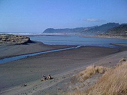
Lincoln County is a county located in the U.S. state of Oregon. As of the 2010 census, its population was 46,034. The county seat is Newport. The county is named for Abraham Lincoln, 16th president of the United States.

Lane County, Oregon County in the United States

Lane County is a county in the U.S. state of Oregon. As of the 2010 census, the population was 351,715, making it the fourth-most populous county in Oregon. The county seat is Eugene. It is named in honor of Joseph Lane, Oregon's first territorial governor.

Jackson County, Oregon County in the United States

Jackson County is a county in the U.S. state of Oregon. As of the 2010 census, the population was 203,206. The county seat is Medford. The county is named for Andrew Jackson, the seventh president of the United States.

Gilliam County, Oregon County in the United States

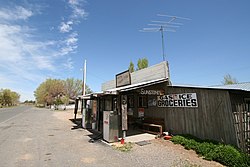
Gilliam County is a county located in the U.S. state of Oregon. As of the 2010 census, the population was 1,871, making it the third-least populous county in Oregon. The county seat is Condon. The county was established in 1885 and is named for Cornelius Gilliam, who commanded the forces of the provisional government of Oregon after the Whitman Massacre.

Deschutes County, Oregon County in the United States

Deschutes County is a county in the U.S. state of Oregon. As of the 2010 census, the population was 157,733. The county seat is Bend. The county was created in 1916 out of part of Crook County and was named for the Deschutes River, which itself was named by French-Canadian trappers of the early 19th century. It is the political and economic hub of Central Oregon.

Coos County, Oregon County in the United States

Coos County is a county in the U.S. state of Oregon. As of the 2010 census, the population was 63,043. The county seat is Coquille. The county was formed from the western parts of Umpqua and Jackson counties. It is named after a tribe of Native Americans who live in the region.

Clatsop County, Oregon County in the United States

Clatsop County is a county in the U.S. state of Oregon. As of the 2010 census, the population was 37,039. The county seat is Astoria. The county is named for the Clatsop tribe of Native Americans, who lived along the coast of the Pacific Ocean prior to European settlement.

Clackamas County, Oregon County in the United States

Clackamas County is a county in the U.S. state of Oregon. As of the 2010 census, the population was 375,992, making it Oregon's third-most populous county. Its county seat is Oregon City. The county was named after the Native Americans living in the area, the Clackamas Indians, who were part of the Chinookan people.

Benton County, Oregon County in the United States

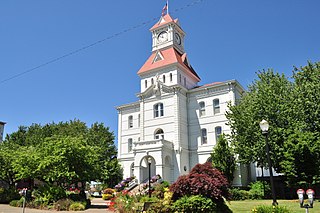
Benton County is a county in the U.S. state of Oregon. As of the 2010 census, the population was 85,579. Its county seat is Corvallis. The county was named after Thomas Hart Benton, a U.S. Senator who advocated American control over the Oregon Country.

Oregon County, Missouri County in the United States

Oregon County is a county located in the southern portion of the U.S. state of Missouri. As of the 2010 census, the population was 10,881. Its county seat is Alton. The county was officially organized on February 14, 1845, and was named for the Oregon Territory in the northwestern United States.

Ogle County, Illinois County in the United States

Ogle County is a county located in the U.S. state of Illinois. According to the 2010 United States Census, it had a population of 53,497. Its county seat is Oregon, and its largest city is Rochelle.

Portland metropolitan area Metropolitan area in the United States

The Portland metropolitan area or Greater Portland is a metropolitan area in the U.S. states of Oregon and Washington centered on the principal city of Portland, Oregon. The U.S. Office of Management and Budget identifies it as the Portland–Vancouver–Hillsboro, OR–WA Metropolitan Statistical Area, a metropolitan statistical area used by the United States Census Bureau (USCB) and other entities. The OMB defines the area as comprising Clackamas, Columbia, Multnomah, Washington, and Yamhill Counties in Oregon, and Clark and Skamania Counties in Washington. The area's population is estimated at 2,753,168 in 2017.

Oregons 2nd congressional district

Oregon's 2nd congressional district is the largest of Oregon's five districts, and is the seventh largest district in the nation. The district covers roughly two-thirds of the state, east of the Willamette Valley. It includes all of Baker, Crook, Deschutes, Gilliam, Grant, Harney, Hood River, Jackson, Jefferson, Klamath, Lake, Malheur, Morrow, Sherman, Umatilla, Union, Wallowa, Wasco, Wheeler counties, and part of eastern Josephine county, including some of the Grants Pass area.

Oregon statistical areas Wikimedia list article

The statistical areas of the United States of America comprise the metropolitan statistical areas (MSAs), the micropolitan statistical areas (μSAs), and the combined statistical areas (CSAs) currently defined by the United States Office of Management and Budget (OMB).

References