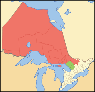
Northern Ontario is a primary geographic and quasi-administrative region of the Canadian province of Ontario, the other primary region being Southern Ontario. Most of the core geographic region is located on part of the Superior Geological Province of the Canadian Shield, a vast rocky plateau located mainly north of Lake Huron, the French River, Lake Nipissing, and the Mattawa River. The statistical region extends south of the Mattawa River to include all of the District of Nipissing. The southern section of this district lies on part of the Grenville Geological Province of the Shield which occupies the transitional area between Northern and Southern Ontario. The extended federal and provincial quasi-administrative regions of Northern Ontario have their own boundaries even further south in the transitional area that vary according to their respective government policies and requirements. Ontario government departments and agencies such as the Growth Plan for Northern Ontario and the Northern Ontario Heritage Fund Corporation define Northern Ontario as all areas north of, and including, the districts of Parry Sound and Nipissing for political purposes, whilst the federal government, but not the provincial, also includes the district of Muskoka.

Georgian Bay is a large bay of Lake Huron, in the Laurentia bioregion. It is located entirely within the borders of Ontario, Canada. The main body of the bay lies east of the Bruce Peninsula and Manitoulin Island. To its northwest is the North Channel.

Nickel Belt is one of two federal electoral districts serving the city of Greater Sudbury, Ontario, Canada. It has been represented in the House of Commons of Canada since 1953.

The Sudbury District is a district in Northeastern Ontario in the Canadian province of Ontario. It was created in 1894 from townships of eastern Algoma District and west Nipissing District.

Manitoulin District is a district in Northeastern Ontario within the Canadian province of Ontario. It was created in 1888 from part of the Algoma District. The district seat is in Gore Bay.

Lake Nipissing is a lake in the Canadian province of Ontario. It has a surface area of 873.3 km2 (337.2 sq mi), a mean elevation of 196 m (643 ft) above sea level, and is located between the Ottawa River and Georgian Bay. Lake Nipissing is the third-largest lake entirely in Ontario. It is relatively shallow for a large lake, with an average depth of only 4.5 m (15 ft). The shallowness of the lake makes for many sandbars along the lake's irregular shoreline. The lake reaches a maximum depth of 64 m (210 ft) near the mouth of the French River, off the shore of Blueberry Island. The lake has many islands most of which are protected under the Protection of Significant Wetlands scheme, controlled by the Ministry of Natural Resources and Forestry.

Parry Sound is a sound or bay of Georgian Bay on Lake Huron, in Ontario, Canada. It is highly irregularly shaped with many deep bays and islands. Killbear Provincial Park is located on the large peninsula that separates the sound from Georgian Bay, while it is bordered on the south side by Parry Island, home of the Wasauksing First Nation. At the head of the sound is the namesake town that is the largest community on the shores of Georgian Bay from Severn Sound to Manitoulin Island.
The 1908 Ontario general election was the 12th general election held in the Province of Ontario, Canada. It was held on June 8, 1908, to elect the 106 Members of the 12th Legislative Assembly of Ontario ("MLAs").
An unorganized area or unorganized territory is any geographic region in Canada that does not form part of a municipality or Indian reserve. In these areas, the lowest level of government is provincial or territorial. In some of these areas, local service agencies may have some of the responsibilities that would otherwise be covered by municipalities.
The Robinson Treaties are two treaties signed between the Ojibwa chiefs and The Crown in 1850 in the Province of Canada. The first treaty involved Ojibwa chiefs along the north shore of Lake Superior, and is known as the Robinson Superior Treaty. The second treaty, signed two days later, included Ojibwa chiefs from along the eastern and northern shores of Lake Huron, and is known as the Robinson Huron Treaty. The Wiikwemkoong First Nation did not sign either treaty, and their land is considered "unceded".
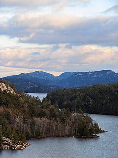
The La Cloche Mountains, also called the La Cloche Range, are a range of mountains in Northern Ontario, Canada, along the northern shore of Lake Huron near Manitoulin Island. The mountains are located in the Canadian Shield, and are composed primarily of white quartzite.
Nipissing First Nation is a long-standing community of Nishnaabeg peoples located along the shorelines of Lake Nipissing in northern Ontario. They are referred to by many names in European historical records, since the colonists often adopted names given to them by other nations.

Rainbow Country is a local services board in the Canadian province of Ontario. It encompasses and provides services to the communities of Whitefish Falls and Willisville in the Unorganized North Sudbury District and Birch Island and McGregor Bay in the Manitoulin District.

The Almaguin Highlands Region in Ontario, Canada, covers approximately 5,200 km2 (2,000 sq mi) comprising the eastern half of Parry Sound District. It is bounded by Muskoka in the south, and by Lake Nipissing and Nipissing District in the north. The eastern edge abuts the western boundary of Algonquin Provincial Park, whereas the western boundary of the Almaguin Highlands is generally regarded to be the mid east-west point of Parry Sound District. Originally derived from the words, Algonquin, Magnetawan, and Seguin. Almaguin is now used to describe the marketing region of East Parry Sound.
There are 65 lakes known as Long Lake in Ontario, Canada.
There are a number of Sand Lakes in Ontario: