
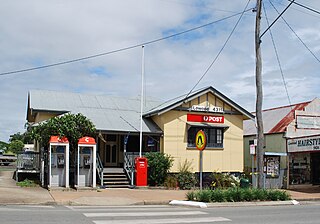
Esk is a town and locality in the Somerset Region in South East Queensland, Australia. In the 2016 census, Esk had a population of 1,698 people.
Lowood is a rural town and locality in the Somerset Region, Queensland, Australia. In the 2016 census, the locality of Lowood had a population of 4,159 people.
Glamorgan Vale is a rural town and locality in the Somerset Region, Queensland, Australia. In the 2016 census, the locality of Glamorgan Vale had a population of 404 people.
Minden is a rural town and locality in the Somerset Region, Queensland, Australia. The town is 64 kilometres (40 mi) west of the state capital, Brisbane. In the 2016 census, the locality of Minden had a population of 1,204 people.

Haigslea is a locality split between the City of Ipswich and the Somerset Region in South East Queensland, Australia. In the 2016 census, Haigslea had a population of 468 people.

Fairney View is a rural locality in the Somerset Region, Queensland, Australia. In the 2016 census, Fairney View had a population of 223 people.

Coolana is a rural locality in the Somerset Region, Queensland, Australia. In the 2021 census, Coolana had a population of 175 people.

Rifle Range is a locality in the Somerset Region, Queensland, Australia. In the 2016 census, Rifle Range had a population of 186 people.
Clarendon is a rural locality in the Somerset Region, Queensland, Australia. In the 2016 census, Clarendon had a population of 244 people.

Withcott is a rural town and locality in the Lockyer Valley Region, Queensland, Australia. In the 2021 census, the locality of Withcott had a population of 2,067 people.
Hatton Vale is a rural locality in the Lockyer Valley Region, Queensland, Australia. In the 2016 census, Hatton Vale had a population of 1,521 people.
Blanchview is a rural locality in the Lockyer Valley Region, Queensland, Australia. In the 2016 census, Blanchview had a population of 191 people.

Blenheim is a rural locality in the Lockyer Valley Region, Queensland, Australia. In the 2016 census, Blenheim had a population of 291 people.

Mount Whitestone is a rural locality in the Lockyer Valley Region, Queensland, Australia. In the 2016 census, Mount Whitestone had a population of 154 people.

Ropeley is a rural locality in the Lockyer Valley Region, Queensland, Australia. In the 2016 census Ropeley had a population of 194 people.

Teviotville is a rural locality in the Scenic Rim Region, Queensland, Australia. In the 2021 census, Teviotville had a population of 114 people.

Witta is a rural town and locality in the Sunshine Coast Region, Queensland, Australia. In the 2021 census, the locality of Witta had a population of 1,296 people.

Mount Sylvia is a rural locality in the Lockyer Valley Region, Queensland, Australia. In the 2016 census, Mount Sylvia had a population of 106 people.

Brightview is a locality split between the Lockyer Valley Region and Somerset Region, Queensland, Australia. In the 2016 census, Brightview had a population of 813 people.

Lockyer Waters is a rural locality in the Lockyer Valley Region, Queensland, Australia. In the 2016 census, Lockyer Waters had a population of 561 people.


