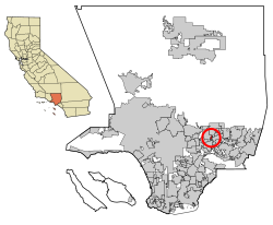
Mayflower Village, California | |
---|---|
Coordinates: 34°7′4″N118°0′34″W / 34.11778°N 118.00944°W | |
Country | United States |
State | California |
County | Los Angeles |
Area | |
• Total | 0.687 sq mi (1.779 km2) |
• Land | 0.687 sq mi (1.779 km2) |
• Water | 0 sq mi (0 km2) 0% |
Elevation | 367 ft (112 m) |
Population | |
• Total | 5,402 |
• Density | 7,900/sq mi (3,000/km2) |
Time zone | UTC-8 (PST) |
• Summer (DST) | UTC-7 (PDT) |
ZIP code | 91006 & 91016 |
Area code | 626 |
FIPS code | 06-46436 |
GNIS feature ID | 1867040 |
Mayflower Village is a census-designated place (CDP) in the San Gabriel Valley, in Los Angeles County, California, United States. The population was 5,515 at the 2010 census, up from 5,081 at the 2000 census. The ZIP Codes serving the community are 91006, which is served by Arcadia and 91016, which is served by Monrovia. [3]
According to the United States Census Bureau, the CDP has a total area of 0.7 square miles (1.8 km2), all land.
Census | Pop. | Note | %± |
---|---|---|---|
1980 | 5,017 | — | |
1990 | 4,978 | −0.8% | |
2000 | 5,081 | 2.1% | |
2010 | 5,515 | 8.5% | |
2020 | 5,402 | −2.0% | |
U.S. Decennial Census [4] 1850–1870 [5] [6] 1880-1890 [7] 1900 [8] 1910 [9] 1920 [10] 1930 [11] 1940 [12] 1950 [13] 1960 [14] 1970 [15] 1980 [16] 1990 [17] 2000 [18] 2010 [19] 2020 [20] |
Mayflower Village first appeared as a census designated place in the 1980 U.S. Census. [16] Prior to that, it was part of the unincorporated portion of the Upper San Gabriel Valley census county division. [15]
Race / Ethnicity (NH = Non-Hispanic) | Pop 2000 [21] | Pop 2010 [22] | Pop 2020 [20] | % 2000 | % 2010 | % 2020 |
---|---|---|---|---|---|---|
White alone (NH) | 2,680 | 2,047 | 1,469 | 52.75% | 37.12% | 27.19% |
Black or African American alone (NH) | 54 | 76 | 63 | 1.06% | 1.38% | 1.17% |
Native American or Alaska Native alone (NH) | 9 | 10 | 9 | 0.18% | 0.18% | 0.17% |
Asian alone (NH) | 837 | 1,711 | 2,127 | 16.47% | 31.02% | 39.37% |
Native Hawaiian or Pacific Islander alone (NH) | 7 | 4 | 1 | 0.14% | 0.07% | 0.02% |
Other race alone (NH) | 13 | 9 | 23 | 0.26% | 0.16% | 0.43% |
Mixed race or Multiracial (NH) | 129 | 137 | 203 | 2.54% | 2.48% | 3.76% |
Hispanic or Latino (any race) | 1,352 | 1,521 | 1,507 | 26.61% | 27.58% | 27.90% |
Total | 5,081 | 5,515 | 5,402 | 100.00% | 100.00% | 100.00% |
At the 2010 census Mayflower Village had a population of 5,515. The population density was 8,030.2 inhabitants per square mile (3,100.5/km2). The racial makeup of Mayflower Village was 2,929 (53.1%) White (37.1% Non-Hispanic White), [23] 83 (1.5%) African American, 28 (0.5%) Native American, 1,734 (31.4%) Asian, 4 (0.1%) Pacific Islander, 491 (8.9%) from other races, and 246 (4.5%) from two or more races. Hispanic or Latino of any race were 1,521 persons (27.6%). [24]
The census reported that 5,511 people (99.9% of the population) lived in households, 4 (0.1%) lived in non-institutionalized group quarters, and no one was institutionalized.
There were 1,905 households, 656 (34.4%) had children under the age of 18 living in them, 1,078 (56.6%) were opposite-sex married couples living together, 249 (13.1%) had a female householder with no husband present, 98 (5.1%) had a male householder with no wife present. There were 81 (4.3%) unmarried opposite-sex partnerships, and 9 (0.5%) same-sex married couples or partnerships. 385 households (20.2%) were one person and 177 (9.3%) had someone living alone who was 65 or older. The average household size was 2.89. There were 1,425 families (74.8% of households); the average family size was 3.34.
The age distribution was 1,197 people (21.7%) under the age of 18, 435 people (7.9%) aged 18 to 24, 1,433 people (26.0%) aged 25 to 44, 1,692 people (30.7%) aged 45 to 64, and 758 people (13.7%) who were 65 or older. The median age was 41.1 years. For every 100 females, there were 92.5 males. For every 100 females age 18 and over, there were 89.7 males.
There were 1,975 housing units at an average density of 2,875.7 per square mile, of the occupied units 1,559 (81.8%) were owner-occupied and 346 (18.2%) were rented. The homeowner vacancy rate was 1.0%; the rental vacancy rate was 6.0%. 4,464 people (80.9% of the population) lived in owner-occupied housing units and 1,047 people (19.0%) lived in rental housing units.
According to the 2010 United States Census, Mayflower Village had a median household income of $76,461, with 5.6% of the population living below the federal poverty line. [23]
According to the census [25] of 2000, there were 5,081 people, 1,825 households, and 1,315 families in the CDP. The population density was 7,652.3 inhabitants per square mile (2,954.6/km2). There were 1,915 housing units at an average density of 2,884.1 per square mile (1,113.6/km2). The racial makeup of the CDP was 66.38% White, 1.18% African American, 0.69% Native American, 16.55% Asian, 0.18% Pacific Islander, 10.35% from other races, and 4.66% from two or more races. Hispanic or Latino of any race were 26.61% of the population.
Of the 1,825 households 32.9% had children under the age of 18 living with them, 56.8% were married couples living together, 10.6% had a female householder with no husband present, and 27.9% were non-families. 22.8% of households were one person and 10.9% were one person aged 65 or older. The average household size was 2.78 and the average family size was 3.30.
The age distribution was 24.7% under the age of 18, 6.6% from 18 to 24, 30.3% from 25 to 44, 23.8% from 45 to 64, and 14.6% 65 or older. The median age was 38 years. For every 100 females, there were 93.9 males. For every 100 females age 18 and over, there were 90.5 males.
The median household income was $55,547 and the median family income was $63,814. Males had a median income of $40,783 versus $35,634 for females. The per capita income for the CDP was $21,790. About 6.7% of families and 7.0% of the population were below the poverty line, including 8.1% of those under age 18 and 8.7% of those age 65 or over.
In the California State Senate, Mayflower Village is split between the 22nd Senate District , represented by Democrat Susan Rubio, and the 25th Senate District , represented by Democrat Sasha Renée Pérez. In the California State Assembly, it is split between the 48th Assembly District , represented by Democrat Blanca Rubio, and the 49th Assembly District , represented by Democrat Mike Fong. [26]
In the United States House of Representatives, Mayflower Village is split between California's 27th congressional district , represented by Democrat George T. Whitesides, and California's 32nd congressional district , represented by Democrat Brad Sherman. [27]
Bayview is a census-designated place (CDP) located adjacent to the City of Eureka in Humboldt County, California, United States. Its population is 2,619 as of the 2020 census, up from 2,510 from the 2010 census. Many locals consider this area as part of "Pine Hill."
Alondra Park, also known as El Camino Village, is an unincorporated community and census designated place (CDP) in the South Bay region of Los Angeles County, California, United States. It is the unincorporated area north of Alondra Community Regional Park and El Camino College. It is east of Lawndale, south of Hawthorne, west of Gardena, and north of Torrance. Manhattan Beach Boulevard and Crenshaw Boulevard are the two major cross streets in the area. The population was 8,569 at the 2020 census, down from 8,592 at the 2010 census. There is an official Alondra Park Post Office of the U.S. Postal Service in nearby Gardena, California. Urbanized cement-lined Dominguez Creek bisects a portion of Alondra Park.
Citrus is a census-designated place (CDP) in Los Angeles County, California, United States. It is located in the San Gabriel Valley between Azusa to the north and west, Glendora to the east, and Covina to the south.
Del Aire is a census-designated place (CDP) in the inland South Bay, Los Angeles County, California, United States, between El Segundo and Hawthorne. The population was 10,001 at the 2010 census, up from 9,012 at the 2000 census.
Desert View Highlands is a census-designated place (CDP) in Los Angeles County, California, United States. The population was 2,360 at the 2010 census, up from 2,337 at the 2000 census. It is surrounded by the City of Palmdale.
East Whittier is an unincorporated community in Los Angeles County, California, United States. The population was 9,757 at the 2010 census, up from 9,538 at the 2000 census. For statistical purposes, the United States Census Bureau has defined this community as a census-designated place (CDP). The name was changed from East La Mirada in 2012, likely due to its precise location in relation to the city of Whittier.
East Pasadena is an unincorporated community and census designated place (CDP) in Los Angeles County, California, United States. The population was 6,021 at the 2020 census, down from 6,144 at the 2010 census. For statistical purposes, the United States Census Bureau has defined East Pasadena as a census-designated place (CDP).
East San Gabriel is an unincorporated community and census-designated place (CDP) in Los Angeles County, California, United States. The population was 14,874 at the 2010 census, up from 14,512 at the 2000 census.
West Athens is a census-designated place (CDP) in Los Angeles County, California. The population was 9,393 at the 2020 census. It is an unincorporated community within the 2nd Supervisorial District of Los Angeles County. West Athens is served by the Los Angeles County Sheriff's Department, operating out of the South Los Angeles Station. The approximate boundaries for West Athens are: 87th Street to the north, Vermont Avenue to the east, El Segundo Boulevard to the south, and approximately Western Avenue to Van Ness Avenue to the west. West Athens is predominantly residential, with commercial uses along its main corridors. Los Angeles Southwest Community College lies within the West Athens neighborhood and city limits.
West Rancho Dominguez, formerly known as West Compton and also known as East Gardena, is an unincorporated census-designated place (CDP) located in southern Los Angeles County, California. Per the 2020 census, the population was 24,347. The community lies to the west of the city of Compton. The ZIP Codes encompassing the CDP area are 90220 & 90248.
Westmont is an unincorporated community in Los Angeles County, California, a part of the South Los Angeles area, just east of Inglewood. The population was 33,913 at the 2020 census, up from 31,853 at the 2010 census. For statistical purposes, the United States Census Bureau has defined Westmont as a census-designated place (CDP).
Covelo is a census-designated place (CDP) in Mendocino County, California, United States. Covelo is located 14 miles (23 km) east-northeast of Laytonville, at an elevation of 1,398 feet (426 m). The population was 1,394 at the 2020 census, up from 1,255 at the 2010 census. 405 acres (1.64 km2) of Covelo is part of the Round Valley Indian Reservation.
Storrie is an unincorporated community and former census-designated place (CDP) in Plumas County, California and about 20 miles northeast of Lake Oroville. As of the 2010 Census, the CDP had a population of four.
Big River is a census-designated place (CDP) in San Bernardino County, California, United States. The population was 1,084 at the 2020 census, down from 1,327 at the 2010 census.
Bluewater is a census-designated place (CDP) in San Bernardino County, California, United States. The population was 172 at the 2010 census, down from 265 at the 2000 census.
Camp Pendleton Mainside is a census-designated place (CDP) in San Diego County, California, located at the southeast corner of Marine Corps Base Camp Pendleton. Per the 2020 census, the population was 9,683. It was formerly known as Camp Pendleton North, but its name was changed for the 2020 Census. Along with Camp Pendleton South, it is one of two CDPs located on the base.
Highlands-Baywood Park is an unincorporated community and former census designated place (CDP) in San Mateo County, California, United States. The population was 4,027 at the 2010 census.
Amesti is a census-designated place (CDP) in Santa Cruz County, California, United States. The population was 2,637 as of the 2020 United States census.
Bret Harte is a census-designated place (CDP) in Stanislaus County, California, United States. The population was 5,152 at the 2010 census, down from 5,161 at the 2000 census. It is part of the Modesto Metropolitan Statistical Area. It is named for the American poet and short story writer, Bret Harte, best known for his writings about the California Gold Rush.
Malaga is a census-designated place in Fresno County, California. It is located 6 miles (9.7 km) south-southeast of downtown Fresno, at an elevation of 295 feet. As of the 2020 census, Malaga had a population of 884.