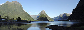
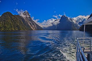
Moana Uta (Wet Jacket Arm) Marine Reserve

Last updated
Moana Uta (Wet Jacket Arm) Marine Reserve
Wet Jacket Arm.jpg
Wet Jacket Arm
NZ Fiordland relief location map.svg
Red pog.svg
Location Fiordland, New Zealand
Coordinates 45°38′23″S166°42′42″E / 45.6398245°S 166.7117861°E / -45.6398245; 166.7117861 Coordinates: 45°38′23″S166°42′42″E / 45.6398245°S 166.7117861°E / -45.6398245; 166.7117861
Area2,007 hectares (4,960 acres)
Established2005
Governing body Department of Conservation

Moana Uta (Wet Jacket Arm) Marine Reserve is a marine reserve covering the entire length of Wet Jacket Arm in Fiordland on New Zealand's South Island, an area of 2,007 hectares (4,960 acres). It was established in 2005 and is administered by the Department of Conservation. [1] [2]

Contents

Geography and ecology

The marine reserve covers the sound between Entry Island and the head of the sound. [3]

In the fiords, heavy rainfall runs off from the surrounding mountains creates a permanent freshwater layer to about 5 centimetres (2.0 in) to 10 metres (33 ft) below the surface. A layer of calm, clear and warm seawater provides a habitat for a range of sponges, corals and fish to about 40 metres (130 ft) below the surface. A final layer of seawater, too darkened by tannins from vegetation run-off to support most marine life, extends to depths of up to 400 metres (1,300 ft). [4]

The fiords are also a habitat for black corals and brittle stars that live in their branches. [5] There are also brachiopods, aihe (bottlenose dolphins), kekono (New Zealand fur seals), tawaki (Fiordland crested penguins) and kororā (little blue penguins). [4]

The Wet Jacket Arm has extensive rock wall, broken rocky reef, deep basin and estuaries. Some rocky reefs under the tidal zone have dense beds of kelp and some kina. Rock walls near Oke Island have more tidal flow, which supports lampshells (brachiopods) and other suspension feeders. [1]

The main deep basin has steep rock wall and no exposure to the open ocean swell, with a moderate to thin freshwater layer, and a large amount of shading from nearby mountains, providing a habitat for the highest density of black coral in Fiordland. [1]

History

The crew of HMS Resolution discovered the area for Europe in 1773. Captain James Cook named the inlet the Wet Jacket Arm after a night when some of the crew rowed the length of the inlet in good weather, only for the weather to change. The group spent the night in wet clothes, unable to light a fire to dry themselves or cook food, and kept away by a storm. [6] [7]

Moose captured by the Canadian Government in Canada were introduced to Fiordland in 1910 and were photographed several times between 1923 and 1952. One photograph, supposedly taken in Wet Jacket Arm in 1953, [8] [9] later turned out from a different location. [10] [11] "Moose hunting" trips continue in the 20th century. [12]

The reserve was part of a conservation strategy the Fiordland Marine Guardians launched in 2002 and presented to the Ministry for the Environment Marian Hobbs and Minister of Fisheries Pete Hodgson in 2003. [13] It was officially established on 21 April 2005. [14] [2]

The Ministry of Primary Industries, Fiordland Marine Guardians and other agencies are involved in protecting the marine reserve and stopping the spread of invasive seaweed. [4]

The New Zealand Air Force conducted aerial surveillance patrols for illegal commercial fishing in 2021. [15]

Research and commerce

Educational and scientific activities are encouraged, but must not disturb or endanger plants, animals or natural features. Scientific research requires a permit from the Department of Conservation. [4]

Recreation

The reserve is accessible from Te Anau via the Milford Road. Anchoring boats is banned in many areas to protect the particularly fragile species that can be damaged by anchors or swinging chains. Taking off and landing aircraft is permitted. [4]

The protected marine life can be viewed by diving or snorkelling, either independently or with a tourism or charter boat service. To protect the fragile environments, divers must follow the safety and care codes. [4]

There is a ban on fishing, and taking, killing or moving marine life and materials. However, members of Ngāi Tahu may remove pounamu provided they have the right authorisation, only collect by hand, keep disturbance to the site to a minimum, and only carry as much as they can in one trip. They may also collect deceased marine mammals and collect teeth and bones. [4]

See also

Related Research Articles

<span class="mw-page-title-main">Milford Sound</span> Fiord in the south west of New Zealands South Island

Milford Sound / Piopiotahi is a fiord in the south west of New Zealand's South Island within Fiordland National Park, Piopiotahi Marine Reserve, and the Te Wahipounamu World Heritage site. It has been judged the world's top travel destination in an international survey and is acclaimed as New Zealand's most famous tourist destination. Rudyard Kipling had previously called it the eighth Wonder of the World. The fiord is most commonly accessed via road by tour coach, with the road terminating at a small village also called Milford Sound.
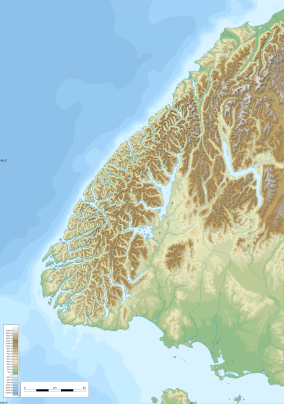
<span class="mw-page-title-main">Fiordland</span> Geographical region of New Zealand

Fiordland is a geographical region of New Zealand in the south-western corner of the South Island, comprising the westernmost third of Southland. Most of Fiordland is dominated by the steep sides of the snow-capped Southern Alps, deep lakes, and its steep, glacier-carved and now ocean-flooded western valleys. The name "Fiordland" comes from a variant spelling of the Scandinavian word for this type of steep valley, "fjord". The area of Fiordland is dominated by, and very roughly coterminous with, Fiordland National Park, New Zealand's largest National Park.

<span class="mw-page-title-main">Fiordland National Park</span> National park on South Island of New Zealand

Fiordland National Park occupies the southwest corner of the South Island of New Zealand. It is by far the largest of the 13 national parks in New Zealand, with an area of 12,607 square kilometres (4,868 sq mi), and a major part of the Te Wahipounamu World Heritage Site. The park is administered by the Department of Conservation.

<span class="mw-page-title-main">Doubtful Sound / Patea</span> Fiord in New Zealand

Doubtful Sound / Patea is a fiord in Fiordland, in the far south west of New Zealand. It is located in the same region as the smaller but more famous and accessible Milford Sound / Piopiotahi. It took second place after Milford Sound as New Zealand's most famous tourism destination.

<span class="mw-page-title-main">Rakituma / Preservation Inlet</span> Fiord in the South Island of New Zealand

Rakituma / Preservation Inlet is the southernmost fiord in Fiordland National Park and lies on the southwest corner of the South Island of New Zealand. With an area of 93 square kilometres (36 sq mi), it is the fourth largest fiord in New Zealand, after Tamatea / Dusky Sound, Doubtful Sound / Patea, and the neighbouring Taiari / Chalky Inlet to the north. Rakituma was briefly the site of an attempted fishing and gold mining settlement at Cromarty during the 19th century, however this was quickly abandoned once the level of gold declined in relation to more promising fields elsewhere.

Hāwea / Bligh Sound is a fiord of the South Island of New Zealand. It is located in Fiordland, 30 kilometres southwest of Milford Sound, and is 15 kilometres in length. The fiord forms a crooked "Z" shape. Wild Natives River flows into the innermost arm, Bounty Haven.

Hawea Marine Reserve is a marine reserve covering an area of 411 hectares in Bligh Sound, in Fiordland on New Zealand's South Island. It was established in 2005 and is administered by the Department of Conservation.

<span class="mw-page-title-main">Taiari / Chalky Inlet</span> Inlet in New Zealand

Taiari / Chalky Inlet is one of the southernmost fiords in Fiordland, in the southwestern corner of New Zealand's South Island and part of Fiordland National Park. As with the neighbouring fiords of Tamatea / Dusky Sound to the north and Rakituma / Preservation Inlet to the south, Taiari / Chalky Inlet is a complex fiord with many channels and islands along its roughly 28 kilometres (17 mi) length. Most notably, this includes the sections Moana-whenua-pōuri / Edwardson Sound and Te Korowhakaunu / Kanáris Sound, which split at Divide Head in the middle of Taiari and each extend for roughly 10 kilometres (6.2 mi) inland in a V-shape.

<span class="mw-page-title-main">Ulva Island-Te Wharawhara Marine Reserve</span>

Ulva Island-Te Wharawhara Marine Reserve is a marine reserve covering an area of 1,075 hectares south-west and north-east of Ulva Island, in the Paterson Inlet of New Zealand's Stewart Island. It was established in 2004 and is administered by the Department of Conservation.

<span class="mw-page-title-main">Parininihi Marine Reserve</span>

Parininihi Marine Reserve is a marine reserve administered by the Department of Conservation, covering 1,800 hectares in the North Taranaki Bight. It is located offshore of the west coast of New Zealand's North Island, north-east of New Plymouth.

<span class="mw-page-title-main">Punakaiki Marine Reserve</span>

Punakaiki Marine Reserve is a marine reserve administered by the Department of Conservation. The reserve includes the area of sea surrounding the pancake rocks and blowholes at Dolomite Point, at Punakaiki on the West Coast Region of New Zealand's South Island. It also includes most of the coastline on the western edge of Paparoa National Park.

<span class="mw-page-title-main">Tauparikākā Marine Reserve</span>

Tauparikākā Marine Reserve is a marine reserve located offshore about 20 kilometres (12 mi) north of Haast on the West Coast of New Zealand's South Island. It covers the area immediately offshore from Ship Creek, which is also known as Tauparikākā in Māori.

Kahukura Marine Reserve is a marine reserve covering an area of 464 hectares in Charles Sound, in Fiordland on New Zealand's South Island. It was established in 2005 and is administered by the Department of Conservation.

<span class="mw-page-title-main">Kutu Parera (Gaer Arm) Marine Reserve</span>

Kutu Parera Marine Reserve is a marine reserve covering an area of 433 hectares at Gaer Arm in the Bradshaw Sound of Fiordland on New Zealand's South Island. It was established in 2005 and is administered by the Department of Conservation.

<span class="mw-page-title-main">Taumoana (Five Finger Peninsula) Marine Reserve</span>

Taumoana Marine Reserve is a marine reserve covering an area of 464 hectares in Fiordland on New Zealand's South Island. It was established in 2005 and is administered by the Department of Conservation. It is located next to the Five Fingers Peninsula, at the entrance to Tamatea / Dusky Sound.

Te Tapuwae o Hua Marine Reserve is a marine reserve covering an area of 3,672 hectares in Te Awaroa / Long Sound in Fiordland on New Zealand's South Island. It was established in 2005 and is administered by the Department of Conservation.

<span class="mw-page-title-main">Piopiotahi (Milford Sound) Marine Reserve</span>

Piopiotahi Marine Reserve is a marine reserve covering an area of 690 hectares in the Milford Sound / Piopiotahi, in Fiordland on New Zealand's South Island. It was established in 1993 and is administered by the Department of Conservation.

<span class="mw-page-title-main">Taipari Roa (Elizabeth Island) Marine Reserve</span>

Taipari Roa Marine Reserve is a marine reserve covering an area of 613 hectares around Elizabeth Island, in the inner Doubtful Sound / Patea of Fiordland on New Zealand's South Island. It was established in 2005 and is administered by the Department of Conservation.

Te Hapua Marine Reserve is a marine reserve covering an area of 449 hectares of Te Hāpua / Sutherland Sound, in Fiordland on New Zealand's South Island. It was established in 2005 and is administered by the Department of Conservation.

<span class="mw-page-title-main">Te Awaatu Channel (The Gut) Marine Reserve</span>

Te Awaatu Channel Marine Reserve is a marine reserve covering an area of 93 hectares in Fiordland on New Zealand's South Island. It was established in 1993 and is administered by the Department of Conservation.

References

  1. 1 2 3 "Moana Uta (Wet Jacket Arm) Marine Reserve". doc.govt.nz. Department of Conservation.
  2. 1 2 Hutching, Gerard. "Marine protected areas". Te Ara - the Encyclopedia of New Zealand . Ministry for Culture and Heritage.
  3. "Map: Moana Uta (Wet Jacket Arm) Marine Reserve". doc.govt.nz. Department of Conservation.
  4. 1 2 3 4 5 6 7 "Fiordland marine reserves". doc.govt.nz. Department of Conservation.
  5. "Fiordland Marine Reserves". aa.co.nz. Automobile Association of New Zealand.
  6. Esler, Lloyd (27 November 2019). "A miserable night immortalised". stuff.co.nz. Southland Times.
  7. Howie, Cherie (9 January 2021). "The many strange names of New Zealand: From Wet Jacket Arm to Hoon Hay, what's with our oddball place names?". New Zealand Media and Entertainment. New Zealand Herald.
  8. "Secret snaps reveal elusive Fiordland moose". Allied Press. Otago Daily Times. 21 December 2012.
  9. "Moose in Fiordland". Radio New Zealand. 27 June 2011.
  10. Price, Mark (8 August 2012). "Man's moose tale turns out to be false". New Zealand Media and Entertainment. Otago Daily Times.
  11. Harding, Evan (5 March 2020). "'I spied a moose in the Fiordland National Park'". stuff.co.nz.
  12. Warne, Kennedy (November 2006). "The hunt for Fiordland's elusive moose". New Zealand Geographic.
  13. "History". fmg.org.nz. Fiordland Marine Guardians.
  14. "Fiordland (Te Moana o Atawhenua) Marine Management Act 2005". legislation.govt.nz. New Zealand Government.
  15. Baker, Che (7 December 2021). "Illegal fishing targeted in Southland surveillance operation". stuff.co.nz.