Pinecliffe, Colorado | |
|---|---|
 Location in Gilpin County and the state of Colorado  Pinecliffe, Colorado (the United States) | |
| Coordinates: 39°55′55″N105°25′42″W / 39.93194°N 105.42833°W | |
| Country | |
| State | |
| Counties | Boulder, Gilpin |
| Elevation | 8,012 ft (2,442 m) |
| Time zone | UTC-7 (MST) |
| • Summer (DST) | UTC-6 (MDT) |
| ZIP code [2] | 80471 |
| GNIS feature ID | 181137 [1] |
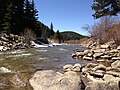
Pinecliffe is a U.S. Post Office and an unincorporated community located in Boulder County and Gilpin County, Colorado, United States. The Pinecliffe Post Office, in Boulder County, [1] has the ZIP Code 80471. [2]