
South Portland is a city in Cumberland County, Maine, United States, and is the fourth-most populous city in the state, incorporated in 1898. At the 2020 census, the city population was 26,498. Known for its working waterfront, South Portland is situated on Portland Harbor and overlooks the skyline of Portland and the islands of Casco Bay. Due to South Portland's close proximity to air, marine, rail, and highway transportation options, the city has become a center for retail and industry in the region. The Maine Mall, the largest shopping mall in the state, is located in South Portland.

Stellenbosch is a town in the Western Cape province of South Africa, situated about 50 kilometres east of Cape Town, along the banks of the Eerste River at the foot of the Stellenbosch Mountain. The town became known as the City of Oaks or Eikestad in Afrikaans and Dutch due to the large number of oak trees that were planted by its founder, Simon van der Stel, to grace the streets and homesteads.

Queenstown, officially Komani, is a town in the middle of the Eastern Cape Province of South Africa, roughly halfway between the smaller towns of Cathcart and Sterkstroom on the N6 National Route. The town was established in 1853 and is currently the commercial, administrative, and educational centre of the surrounding farming district.
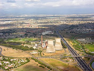
Athlone is a suburb of Cape Town located to the east of the city centre on the Cape Flats, south of the N2 highway. Two of the suburb's main landmarks are Athlone Stadium and the decommissioned coal-burning Athlone Power Station. Athlone is mainly residential and is served by a railway station of the same name. It however includes industrial and commercial zones. There are many "sub-areas" within Athlone, including Gatesville, Rylands, Belgravia Estate, Bridgetown and Hazendal. Colloquially other areas around Athlone are also often included in the greater Athlone area even though the City of Cape Town might classify them as separate neighborhoods such as Rondebosch East, Crawford, and Manenberg.

Mitchells Plain is a large census designated sub-place located within the City of Cape Town, Western Cape, South Africa and situated about 28 km (17 mi) from the Cape Town city centre. It is one of South Africa's largest residential areas and contains multiple smaller suburbs. It is located on the Cape Flats on the False Bay coast between Muizenberg and Khayelitsha. Conceived of as a "model suburb" by the apartheid government, it was built during the 1970s to provide housing for Coloured victims of forced removal due to the implementation of the Group Areas Act.

Brackenfell is a town in the Western Cape province of South Africa, situated on the N1 about 30 km north-east of Cape Town and 35 km south-west of Paarl.

The Southern Suburbs are a group of Anglophone suburbs in Cape Town, Western Cape, South Africa. This group includes, among others, Observatory, Mowbray, Pinelands, Rosebank, Rondebosch, Rondebosch East, Newlands, Claremont, Lansdowne, Kenilworth, Bishopscourt, Constantia, Wynberg, Ottery, Plumstead, Diep River, Bergvliet and Tokai. The area is also commonly referred to as the Cape Peninsula, often including the towns further South such as Fish Hoek.
Grassy Park is a suburb of the City of Cape Town in the Western Cape Province of South Africa.

Ottery is a suburb in Cape Town, South Africa. It is on the edge of the Southern Suburbs. The Youngsfield Military Base, Royal Cape Golf Club and Cape Town's 'official' China Town are located in the suburb. Every year the Youngsfield Military Base in Ottery hosts the Cape Argus Junior Cycle Tour on 12 March. The name was derived off the Otter sanctuary which was opened here in the early 1900's, but was closed down as the neighbourhood rapidly expanded later in the century.
The United Herzlia Schools is an organisation that manages the delivery of separate Jewish education in Cape Town in South Africa.
Portland most commonly refers to:
Spine Road High School is a school in Rocklands, Mitchell's Plain, a township in Cape Town, South Africa.
Eastridge is a neighborhood in the Mitchells Plain urban area of the City of Cape Town in the Western Cape province of South Africa.

Rocklands is a neighborhood located within the Mitchells Plain urban area of the City of Cape Town in the Western Cape province of South Africa. It is located in the south western most corner of Mitchells Plain and borders the community of Strandfontein to its immediate west.
Tafelsig is a neighbourhood in the south eastern corner of the Mitchells Plain urban area of the City of Cape Town in the Western Cape province of South Africa.

Lentegeur is a neighbourhood in the north eastern section of the Mitchells Plain urban area of the City of Cape Town in the Western Cape province of South Africa. The 400 bed Mitchells Plain Hospital, one of Cape Town's larger hospitals, is located in the neighbourhood. The Lentegeur Sports Grounds dominate the central area of the neighbourhood.
Mandalay is a neighbourhood in the northeastern corner of the Mitchells Plain urban area of the City of Cape Town in the Western Cape province of South Africa.

Westridge is a neighbourhood located within the Mitchells Plain urban area of the City of Cape Town in the Western Cape province of South Africa. It is located in the western part of the Mitchells Plain area. The Westridge Gardens, which hosts several indigenous Cape Flats fynbos species, is an important large public park in the area located in the north of Westridge.

Woodlands is a neighborhood in the central western part of the Mitchells Plain urban area of the City of Cape Town in the Western Cape province of South Africa.
Beacon Valley is a neighborhood in the central eastern part of the Mitchells Plain urban area of the City of Cape Town in the Western Cape province of South Africa, just north and north east of the town centre.

