The West End of London is a district of Central London, London, England, west of the City of London and north of the River Thames, in which many of the city's major tourist attractions, shops, businesses, government buildings and entertainment venues, including West End theatres, are concentrated.

Camden Town is an area in the London Borough of Camden, around 2.5 miles (4 km) north-northwest of Charing Cross. Historically in Middlesex, it is identified in the London Plan as one of 34 major centres in Greater London.
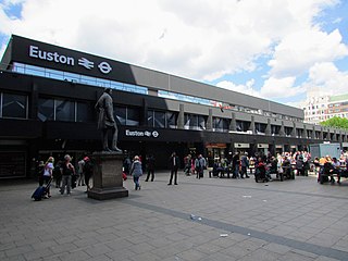
Euston railway station is a major central London railway terminus managed by Network Rail in the London Borough of Camden. It is the southern terminus of the West Coast Main Line, the UK's busiest inter-city railway. Euston is the tenth-busiest station in Britain and the country's busiest inter-city passenger terminal, being the gateway from London to the West Midlands, North West England, North Wales and Scotland.

Regent's Park is one of the Royal Parks of London. It occupies 410 acres (170 ha) in north-west Inner London, administratively split between the City of Westminster and the Borough of Camden. In addition to its large central parkland and ornamental lake, it contains various structures and organizations both public and private, generally on its periphery, including Regent's University and London Zoo.

The Holly Lodge Estate is a housing estate in Highgate, north London.

Cumberland Terrace is a neoclassical terrace on the eastern side of Regent's Park in the London Borough of Camden, completed in 1826. It is a Grade I listed building.

Carlton House Terrace is a street in the St James's district of the City of Westminster in London. Its principal architectural feature is a pair of terraces, the Western and Eastern terraces, of white stucco-faced houses on the south side of the street, which overlook The Mall and St. James's Park. These terraces were built on Crown land between 1827 and 1832 to overall designs by John Nash, but with detailed input by other architects including Decimus Burton. Construction was overseen by James Pennethorne. Both terrace blocks are Grade I listed buildings. A separate but linked cul-de-sac at the terrace's western end is named Carlton Gardens and has a few additional townhomes.

Roundshaw is a housing estate and park in south Wallington and Beddington on the eastern edge of the London Borough of Sutton. Grid Ref TQ302633.
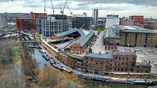
King's Cross Central (KXC) is a mixed-use development in the north-east of central London. The site is owned and controlled by the King's Cross Central Limited Partnership. It consists of approximately 67 acres (27 ha) of former railway lands to the north of King's Cross and St Pancras mainline railway stations. The site is largely determined by three boundaries: the existing East Coast Main Line railway leading out of King's Cross; York Way, a road marking the division between Camden and Islington boroughs; and the new railway line, High Speed 1 (HS1), formerly known as the Channel Tunnel Rail Link, which curves around the site to the north and west.

The Bourne Estate is an Edwardian housing estate in Holborn, located in the London Borough of Camden. It is bounded by Clerkenwell Road to the north, Gray's Inn Road to the west, Leather Lane to the east and Baldwins Gardens to the south. It is also intersected by Portpool Lane, which forms part of the estate itself.

Cumberland Market was a London market between Regent's Park and Euston railway station. It was built in the early 19th century and was London's hay and straw market for a hundred years until the late 1920s. An arm of the Regent's Canal was built to the market. The market was surrounded by modest housing, and in the early 20th century became an artistic community. The original houses were demolished during and after World War II and it is now a housing estate, known as Regent's Park Estate.
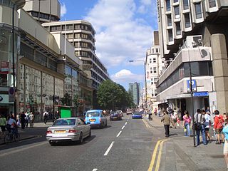
The A400 road is an A road in London that runs from Charing Cross to Archway in North London. It passes some of London's most famous landmarks.

The Heygate Estate was a large housing estate in Walworth, Southwark, South London, comprising 1,214 homes. The estate was demolished between 2011 and 2014 as part of the urban regeneration of the Elephant & Castle area. Home to more than 3,000 people, it was situated adjacent to Walworth Road and New Kent Road, and immediately east of the Elephant & Castle road intersection. The estate was used extensively as a filming location, due in part to its brutalist architecture.
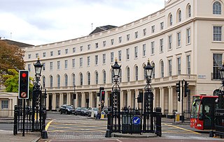
Park Crescent is at the north end of Portland Place and south of Marylebone Road in London. The crescent consists of elegant stuccoed terraced houses by the architect John Nash, which form a semicircle. The crescent is part of Nash's and wider town-planning visions of Roman-inspired imperial West End approaches to Regent's Park. It was originally conceived as a circus (circle) to be named Regent's Circus but instead Park Square was built to the north. The only buildings on the Regent's Park side of the square are small garden buildings, enabling higher floors of the Park Crescent buildings to have a longer, green northern view.

The London Borough of Camden is a borough in Inner London, England. Camden Town Hall, on Euston Road, lies 1.4 mi (2.3 km) north of Charing Cross. The borough was established on 1 April 1965 from the former metropolitan boroughs of Holborn, St Pancras and Hampstead.

The Carpenters Estate is located in Stratford, Newham, East London, close to the Queen Elizabeth Olympic Park. The estate is formed of low rise social housing and three tower blocks. The estate has been continually earmarked for demolition and redevelopment.
Nasim "Nash" Ali is a British Labour Party politician, councillor for Regent's Park, former Cabinet Member for Young People in Camden Council and former Mayor of Camden. In May 2003, at the age of 34, after being elected Mayor of Camden, he became the UK's youngest mayor, as well as the first Bangladeshi and first Muslim mayor.
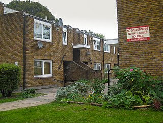
Cressingham Gardens is a council garden estate in Lambeth. It is located on the southern edge of Brockwell Park. It comprises 306 dwellings, a mixture of four, three and two-bedroom houses, and one-bedroom apartments. It was designed at the end of the 1960s by the Lambeth Borough Council Architect Edward Hollamby and second architect Roger Westman, and built at the start of the 1970s. In 2012 Lambeth Council proposed demolishing the estate, to replace the terraced houses by apartment blocks. Most of the apartments would then be for sale to the private sector. The residents, those in Lambeth who wish to prevent the gentrification of the borough, and those who want to conserve what they believe to be important architectural heritage, are campaigning to prevent its demolition.
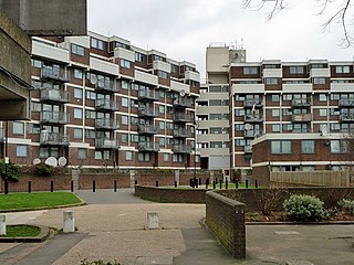
The Nightingale Estate is located in the Lower Clapton area of the London Borough of Hackney, next to Hackney Downs. The estate originally consisted of six 22 story tower blocks, but was redeveloped between 2003-2006 and replaced with mostly low-rise buildings. Only one of the towers, Seaton Point, still remains.

South Kilburn is a large housing estate in Kilburn, in the London Borough of Brent. Typical of brutalist 1960s designs of public housing in the United Kingdom, it is characterised by high-density housing in low-rise flats and 11 concrete tower blocks. It was approved in 1959 and extended in 1963. This scheme was further developed in the late 1960s and early 1970s; redevelopment occurred during the 2010s. The population is predominantly Afro-Caribbean and Pashtun.


