Around 2 million to 8000 B.C., based on geologic findings, during the ice ages (2 million years – 8000 B.C.), the islands of Mindoro, Luzon, and Mindanao were connected as one big island through the islands of Samar, Leyte and Bohol.
Pre-colonial era
In 8550 B.C., diggings in Sohoton Caves in Basey, Samar showed stone flake tools. In 1200 A.D., other diggings along the Basey River revealed other stone flakes used until the 13th century.[6]
Spanish era
In 1543, the explorer Ruy López de Villalobos, first came to the island and named it Las Islas Filipinas.
In 1596, many names, such as Samal, Ibabao, and Tandaya, were given to Samar Island prior to the coming of the Spaniards in 1596. During the early days of Spanish occupation, Samar was under the jurisdiction of Cebu.
On October 15, 1596, the first Jesuit missionaries arrived in Tinago (now Dapdap) in Tarangnan. From Tinago, the missionaries, Fr. Francisco de Otazo, Bartolome Martes and Domingo Alonzo began teaching Catechism, healing the sick and spreading the Christian faith into the interior settlements.
On June 1, 1649, the people of Palapag led by Agustin Sumuroy revolted against the decree of Governor GeneralDiego Fajardo requiring able bodied men from the Visayas for service at the Cavite Shipyards. Like wildfire, the revolt quickly spread to the neighboring town in the Northern and Western coast of Samar and to the nearby provinces of Bicol, Surigao, Cebu, Camiguin and as far as Zamboanga. It was suppressed in 1650 by the combined forces of the Spaniards, Lutaos, and Pampangos.
In 1735, Samar and Leyte were united into one province with Carigara, in Leyte, as the capital town. In 1747, Samar and Leyte were separated for administrative effectiveness. In 1762, complaints from the Jesuits that the division was not working well, thus it was reunited again by the approval from the King of Spain.
In 1768, Jesuits were expelled in all Spanish dominions. The Franciscans arrived on September 25, 1768, and took over the administration of 14 of the 17 parishes which were under the spiritual care of the Jesuits for almost 172 years. The administration of the remaining three parishes namely Guiuan, Balangiga and Basey in the south of Samar were given to the Augustinians.
In 1777, the two provinces were divided for the last time, it was approved in Madrid in 1786 and had been effective in 1799.
In 1803, Guiuan, Balangiga and Basey were turned over to the Franciscans for the lack of Augustinian priests.
On April 15, 1900, the Filipino guerrillas launched a surprise attack on a detachment of the US 43rd Infantry Regiment, forcing the Americans to abandon Catubig town after the four-day siege.
On April 10, 1910, upon the papal bull of Pope Pius X separated the islands of Samar and Leyte from the Diocese of Cebu and erected the Diocese of Calbayog comprising both islands. Pablo Singzon de Anunciacion was named first Bishop and consecrated on June 12, 1910.
On June 19, 1965, the Philippine Congress along with the three Samar Representatives, Eladio T. Balite (1st District), Fernando R. Veloso (2nd District) and Felipe J. Abrigo (3rd District), approved Republic Act No. 4221 dividing the region of Samar into three divisions: Northern Samar, Eastern Samar, and Western Samar. Each region adopted a new capital: Catbalogan (Western Samar), Borongan (Eastern Samar), and Catarman (Northern Samar).[7] The law was later ratified by the majority of voters through a plebiscite held on November 9, 1965.[8] Esteban Piczon, the last governor of undivided Samar, continued as the first governor of Western Samar, while the aforementioned representatives were re-elected for the new provinces in 1965. The first provincial officials of Western Samar were elected on November 14, 1967, and on January 1, 1968, they officially assumed office.
On June 21, 1969, under Republic Act No. 5650, Western Samar was renamed Samar with Catbalogan still as the capital.[9]
The beginning months of the 1970s had marked a period of turmoil and change in the Philippines, as well as in Samar.[10] respectively[11][12][13] During his bid to be the first Philippine president to be re-elected for a second term, Ferdinand Marcos launched an unprecedented number of foreign debt-funded public works projects. This caused[14][15] the Philippine economy to take a sudden downwards turn known as the 1969 Philippine balance of payments crisis, which led to a period of economic difficulty and a significant rise of social unrest.[16][17][18][19]:"43" With only a year left in his last constitutionally allowed term as president, Ferdinand Marcos placed the Philippines under Martial Law in September 1972 and thus retained the position for fourteen more years.[20] This period in Philippine history is remembered for the Marcos administration's record of human rights abuses,[21][22] particularly targeting political opponents, student activists, journalists, religious workers, farmers, and others who fought against the Marcos dictatorship.[23] In Samar province itself, there were a number of Human rights violations particularly associated with the various political detainees at Camp Lukban in Barangay Maulong, which was then still under the Philippine Constabulary.[10]
This era also saw the construction of the San Juanico Bridge between Samar and Leyte, which began as one of the high-visibility foreign-loan funded projects of Ferdinand Marcos’ 1969 reelection campaign, and finished four years later in time to be inaugurated on then-First LadyImelda Marcos' birthday on July 2, 1973.[24] The project was initially criticised as a white elephant by officials at the National Economic and Development Authority, noting that it was "useless and expensive to maintain",[25] because its average daily traffic was too low to justify the cost of its construction.[25] As a result, its construction has been associated with what has been called the Marcoses' "edifice complex"[26][27] although economic activity in Samar and Leyte has since finally caught up with the bridge's intended function.[27] At the time, its name was used as a slang term for onte of the torture methods used by the Marcos dictatorship, in which a person being beaten while the victim's head and feet lay on separate beds and the body is suspended as though to form a bridge.[28][29][30]
The Marcos era was a time of significant deforestation in Samar and throughout the Philippines, with the forest cover of the Philippines shrinking until only 8% remained.[31][32][33] In Samar, one of the major companies given Timber License Agreements (TLAs) to cut down trees during Martial Law was Dolores Timber, which was owned by Juan Ponce Enrile.[33] Enrile was the government official Ferdinand Marcos put in place to approve Timber License Agreements during Martial Law.[33]
Contemporary
The capital town Catbalogan became a component city by virtue of Republic Act No. 9391 which sought to convert the municipality into a city. The law was ratified on June 16, 2007. However, the cityhood status was lost twice in the years 2008 and 2010 after the League of Cities of the Philippines questioned the validity of the cityhood law. The cityhood status was reaffirmed after the Supreme Court finalized its ruling on February 15, 2011, which declared the cityhood law constitutional.
On November 8, 2013, Typhoon Haiyan, locally known as Typhoon Yolanda, hit Samar province.[34] More than 300 people perished on the first day it hit the province.[35]
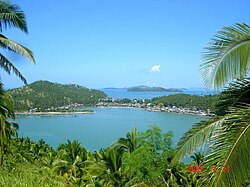
Samar province covers a total area of 6,048.03 square kilometers (2,335.16sqmi)[39] occupying the central-western sections of the Samar island in the Eastern Visayas region. The province is bordered on the north by Northern Samar, east by Eastern Samar, south by Leyte and Leyte Gulf, and west by the Samar Sea.
The population of Samar (province) in the 2020 census was 793,183 people,[3] with a density of 130 inhabitants per square kilometer or 340 inhabitants per square mile.
Samar (Western Samar) is predominantly Roman Catholic. The Catholic Hierarchy (2014) states that 95 percent of its population adhere to Roman Catholicism.
Residents of Samar are mostly Waray, the fifth largest cultural-linguistic group in the country. 90.2 percent of the household population speaks the Waray-Waray language, while 9.8 percent also speak Cebuano; 8.1 percent Boholano; 0.07 percent Tagalog; and 0.5 percent other languages.
There are two types of Waray spoken in the province, Waray Lineyte-Samarnon which is spoken from the southernmost tip of the province up to the municipality of Gandara and Waray Calbayog, an intermediary between the Waray of Northern Samar and the Waray of Samar, spoken in Calbayog, Santa Margarita, and in some parts of Tagapul-an, Santo Niño, Almagro and Matuguinao.
Lieutenant Benedicto Nijaga[52]— nicknamed Biktoy, one of the "Thirteen Martyrs of Bagumbayan", executed on January 11, 1897, in Bagumbayan (Luneta Park). During a raid of a printing press in Binondo, the Spaniards found and confiscated subversive documents including a list of members of the Katipunan. Benedicto Nijaga was on the list as a collector of revolutionary funds. Upon the order of Gov. Polavieja to arbitrarily arrest all suspected members of the Katipunan, Nijaga was arrested while he was campaigning for revolutionary funds.
Cardinal Julio Rosales[53] — (September 18, 1906 – June 2, 1983) the second Archbishop of Cebu, was a Filipinocardinal of the Roman Catholic Church. A native of Calbayog, he made his studies at the Seminary of Calbayog and was ordained in his hometown on June 2, 1929. From 1929 to 1946, he did pastoral work in the diocese of Calbayog. He was consecrated bishop of Tagbilaran on September 21, 1946.
Lucio Godina (March 8, 1908 – November 24, 1936) &Simplicio Godina (March 8, 1908 - December 8, 1936)[54] — were pygopagusconjoined twins from the island of Samar in the Philippines.[55] Born in 1908, these boys from the Philippines later made the trip to the United States, where they became sideshow attractions in such hubs of ‘entertainment’ as Coney Island. In 1928, after various legal difficulties – including narrowly avoiding jail when a man was injured in an alleged drunk driving incident – they married identical (but not conjoined) twin sisters, Natividad and Victorina Matos, in Manila. At the age of 21 they married Natividad and Victorina Matos, who were identical twins. They performed in various sideshow acts, including in an orchestra on Coney Island and in dance with their wives. After Lucio died of rheumatic fever in New York City, doctors operated to separate him from Simplicio. Simplicio survived the operation, but died shortly thereafter due to spinal meningitis.[56]
Chito S. Roño[62] —(born April 26, 1954), also known as Sixto Kayko, is a Filipino writer, film producer and film director from Calbayog known for his expansive vision and special-effects-heavy films, most notably Yamashita: The Tiger's Treasure (2001) for which he won the Metro Manila Film Festival for best director.[63] He is also known for his 1997 film Nasaan ang Puso which earned him his first MMFF for best director. There is an annual literary and visual arts competition held in Samar in honor of him.[64]
Tessie Tomas[65] — (born October 31, 1950), a Filipino actress and TV host from Catbalogan,[66] best known for being the host of the ABS-CBN talk show Teysi ng Tahanan. In an interview with GMA Network's Tunay Na Buhay, Tomas recalled working for an ad agency prior to her career as a presenter and actress. Tessie later appeared in both comedic and dramatic roles, notably in the 2012 remake of the film Mundo Man ay Magunaw and 2015's Buena Familia. In 2018, Tomas played a supporting role in the ABS-CBN soap opera The Blood Sisters.[67]
BishopMaximiano Tuazon Cruz[70] — born in Catbalogan, Philippines and was ordained a priest on November 30, 1947. He was appointed titular bishop to Tanudaia as well as auxiliary bishop to the Diocese of Calbayog on November 10, 1987, and ordained bishop on December 1, 1987. He was appointed bishop to the Diocese of Calbayog on December 21, 1994, and retired from diocese on January 13, 1999. He died on October 9, 2013, at age 90.
Sergio Apostol[74] — (born January 17, 1935) is a Filipino politician born in Catbalogan. In 2008, Sergio Apostol was Chief Presidential Legal Counsel for Philippine President Gloria Macapagal Arroyo. On October 8, 2008, Eduardo Ermita confirmed Apostol's resignation, effective October 30, to prepare for his candidacy, for Leyte congressional seat, in the 2010 Philippine general election. Apostol is a member of the board of Union Bank and the legal consultant of the SSS’ Social Security Commission (SSC). After winning his district's seat as a Lakas-CMD party candidate of Arroyo, Apostol switched allegiance to the Liberal party of Benigno Aquino, the winner of the 2010 Presidential election.[75]
Romero Federico Saenz Quimbo[77] — (born December 12, 1969), also known as Miro Quimbo, is a Filipino politician who currently represents Marikina's 2nd Legislative District in the House of Representatives of the Philippines. He succeeded then-Rep. Del R. De Guzman who won as mayor. Quimbo spent the first two years of elementary school at the Sacred Heart College (now Saint Mary’s College of Catbalogan) in Catbalogan, Samar. He moved to the Marist School in Marikina where he eventually finished his elementary and secondary education.[78]
Joel Porlares — (born January 1, 1961) the fourteenth Supreme Bishop of the Philippine Independent Church, officially the Iglesia Filipina Independiente and informally the "Aglipayan Church". The supreme bishop serves as the spiritual head, chief pastor, and chief executive officer of the said church. Porlares is the 14th in a line of succession that goes back from the first Supreme Bishop and prolific revolutionary figure, Gregorio Aglipay. He has been the incumbent supreme bishop since June 2023. Although born in Tacloban, Porlares was raised in the municipality of Basey in the province of Samar.
Tom Rodriguez[79] — a TV host, singer and actor from Catbalogan, Samar. He was born in Subic Naval Base in Zambales to an American serviceman father and a Filipina mother. One of six siblings, he moved with his two brothers and three sisters with their mother to Pinabacdao, Samar (where their mother hails from). But they grew up in nearby Catbalogan, also in Samar, where Rodriguez studied at Saint Mary's College of Catbalogan (formerly Sacred Heart College) from kindergarten to elementary.[80] He popularized the OPM song “Ikaw Ang Sagot”.[81][82]
↑Togonon, Mark Anthony (1 November 2015). "Enchanted". Manila Bulletin. Retrieved 23 March 2016. ... there are more than a thousand caves in the province alone, most of them still unexplored. "Samar isn't called the Caving Capital of the Philippines for nothing," he says.
↑"List of Provinces". PSGC Interactive. Makati City, Philippines: National Statistical Coordination Board. Retrieved 12 April 2013.
↑Report of the Commission on Elections to the President of the Philippines and the Congress on the Manner the Elections Were Held on November 9, 1965. Manila, Philippines: Bureau of Printing. 1967.
↑Magno, Alexander R., ed. (1998). "Democracy at the Crossroads". Kasaysayan, The Story of the Filipino People Volume 9:A Nation Reborn. Hong Kong: Asia Publishing Company Limited.
↑Abinales, P.N.; Amoroso, Donna J. (2005). State and society in the Philippines. Lanham, MD: Rowman & Littlefield Publishers. ISBN978-0742510234. OCLC57452454.
↑Robles, Raissa (2016). Marcos Martial Law: Never Again: A brief history of torture and atrocity under the New Society. Quezon City: Filipinos for A Better Philippines, Inc. ISBN978-621-95443-1-3. OCLC952277519.
This page is based on this Wikipedia article Text is available under the CC BY-SA 4.0 license; additional terms may apply. Images, videos and audio are available under their respective licenses.