Simi Valley

Last updated
The Simi Valley as seen from Sage Ranch Park. Simi-Valley-from-Sage-Ranch-Park.jpg
The Simi Valley as seen from Sage Ranch Park.

Simi Valley is a synclinal valley in Southern California in the United States. It is an enclosed or hidden valley surrounded by mountains and hills. It is connected to the San Fernando Valley to the east by the Santa Susana Pass and the 118 (Ronald Reagan) freeway, and in the west the narrows of the Arroyo Simi and the Reagan Freeway connect to Moorpark and Ventura, California. The relatively flat bottom of the valley contains soils formed from shales, sandstones, and conglomerates eroded from the surrounding hills of the Santa Susana Mountains to the north, which separate Simi Valley from the Santa Clara River Valley, and the Simi Hills. [1]

Syncline

In structural geology, a syncline is a fold with younger layers closer to the center of the structure. A synclinorium is a large syncline with superimposed smaller folds. Synclines are typically a downward fold (synform), termed a synformal syncline, but synclines that point upwards can be found when strata have been overturned and folded.

Valley Low area between hills, often with a river running through it.

A valley is a low area between hills or mountains typically with a river running through it. In geology, a valley or dale is a depression that is longer than it is wide. The terms U-shaped and V-shaped are descriptive terms of geography to characterize the form of valleys. Most valleys belong to one of these two main types or a mixture of them, at least with respect to the cross section of the slopes or hillsides.

Southern California Place in California, United States

Southern California is a geographic and cultural region that generally comprises California's southernmost counties, and is the second most populous urban agglomeration in the United States. The region is traditionally described as eight counties, based on demographics and economic ties: Imperial, Los Angeles, Orange, Riverside, San Bernardino, San Diego, Santa Barbara, and Ventura. The more extensive 10-county definition, which includes Kern and San Luis Obispo counties, is also used and is based on historical political divisions.

Geology

California State Route 118 east of Simi Valley, seen westwards CA 118 east of Simi Valley.jpg
California State Route 118 east of Simi Valley, seen westwards

Simi Valley borders the Santa Susana Mountains to the north and Simi Hills to the east and south. The valley covers an area of about 62 square miles in southern Ventura County, bordering the San Fernando Valley in Los Angeles County. The Santa Clara River Valley occupies the northwestern corner of the valley. Mountainous terrain of South Mountain and Oak Ridge characterizes the northern and central area. Elevation within the quadrangle ranges from about 250 feet along the arroyo bottoms to over 2200 feet. Steep, highly dissected slopes form much of the boundary of the area. In the southeast, Little Simi Valley, drained by Arroyo Simi/Arroyo Las Posas, separates the southern flank of Oak Ridge from the Las Posas Hills. The Las Posas upland area, a broad elevated region that slopes gently to the south, separates the South Mountain-Oak Ridge highlands from the Las Posas-Camarillo Hills between Little Simi Valley on the east and the Oxnard Plain on the west. This relatively low-lying area is also referred to as the Las Posas Valley. Numerous north-south-trending drainages cut South Mountain and Oak Ridge creating steep narrow canyons on north-facing slopes and wide flat-bottomed canyons with incised streams on south-facing slopes. A network of residential streets and ranch and oilfield roads that traverse the area from U.S. Highway 101 and state highways 118, 23, and 126 provides access to the area. Current land use includes citrus and avocado orchards, oil well drilling and production, sand and gravel quarries, decorative-rock quarries, cattle grazing, suburban residential development, and golf courses. The oldest geologic unit mapped in the Simi Valley quadrangle is the upper Cretaceous Chatsworth Formation. [2] The Sespe Formation consists of alluvial fan and floodplain deposits of interbedded pebble-cobble conglomerate, massive to thick-bedded sandstone, and thin-bedded siltstone and clay-stone. In the northern part of the map area, Sespe Formation is overlain by and inter-fingers with the upper Oligocene to lower Miocene Vaqueros Formation that is composed of transitional and marine sandstone, siltstone, and claystone with local sandy coquina beds. In the Las Posas Hills, Sespe Formation is unconformably overlain by marine sandstones of the middle Miocene Topanga Group that are interlayered with and intruded by basalt flows, breccia, and diabase dikes of the Conejo Volcanics. [3]

Santa Susana Mountains mountain range in Southern California, United States

The Santa Susana Mountains are a transverse range of mountains in Southern California, north of the city of Los Angeles, in the United States. The range runs east-west, separating the San Fernando Valley and Simi Valley on its south from Santa Clara River Valley to the north and Santa Clarita Valley to the northeast. The Oxnard Plain is to the west of Santa Susana Mountains.

Simi Hills mountain range in Southern California, United States

The Simi Hills are a low rocky mountain range of the Transverse Ranges in eastern Ventura County and western Los Angeles County, of southern California, United States.

San Fernando Valley large populated valley in Los Angeles County, California, USA

The San Fernando Valley is an urbanized valley in Los Angeles County, California in the Los Angeles metropolitan area, defined by the mountains of the Transverse Ranges circling it. Home to 1.77 million people, it is north of the larger, more populous Los Angeles Basin.

Suburban development in Simi Valley Simi-Valley-Aerial-from-west-with-mountains-August-2014.jpg
Suburban development in Simi Valley

Deep-marine strata of the upper Miocene Modelo Formation cover the Vaqueros Formation and Topanga Group along the crests and southern flanks of South Mountain and Oak Ridge. They also occur as isolated outcrops in the Las Posas Hills. Locally, Modelo Formation consists of interbedded diatomaceous shale, claystone, mudstone, and siltstone with minor sandstone, limestone, chert, and tuff beds. The most widely exposed rock units in the area are the Plio-Pleistocene marine and non-marine Pico and Saugus Formations that crop out on the southern flank of South Mountain-Oak Ridge. Locally, the Pico Formation consists of marine siltstone and silty shale with minor sandstone and pebbly sandstone. The Saugus Formation overlies and interfingers with the Pico Formation and is composed of interbedded shallow-marine to brackish water sandstone, siltstone, pebble-to-cobble conglomerate, and coquina beds that grade laterally and vertically into non-marine sandstone, siltstone, and conglomerate. A local member of the Saugus Formation is exposed in the southwest corner of the map area. It is predominantly a volcanic breccia conglomerate that resembles the Conejo Volcanics breccia, but is believed to represent remnants of landslide debris shed from the Conejo Volcanics into a local trough during Saugus time. [4]

Breccia Rock composed of broken fragments cemented by a matrix

Breccia is a rock composed of broken fragments of minerals or rock cemented together by a fine-grained matrix that can be similar to or different from the composition of the fragments.

Valley surficial deposits cover the floor and margins of the Little Simi Valley, Santa Clara River Valley in the north, and Arroyo Las Posas in the south, and extend up into the larger canyons that drain South Mountain and Oak Ridge. Extensive surficial deposits are also present in the Las Posas upland area in the southwest. These upper Pleistocene to Holocene sediments consist of older and younger alluvial fan and valley deposits, colluvium, active alluvial fans, and active stream deposits. Pleistocene- to Holocene-age landslide deposits are widespread throughout the Simi quadrangle, especially in the finer grained Tertiary sedimentary units where bedding planes are dip slopes. In addition, massive slumps are present in the Sespe and Vaqueros Formations on anti-dip slopes. Seismic and well data from the San Fernando Valley document evolution of that region from mid-Miocene rifting to north-south contraction. Formations in the western San Fernando Valley subsurface (Cretaceous to Paleogene strata, and Miocene Topanga and Modelo Formations) trace southward to outcrops in the Santa Monica Mountains that constrain faulting along the valley's south basin edge. Cretaceous strata in the Simi Uplift to the west are over 2 km higher than equivalent strata beneath the western San Fernando Valley across a boundary marked by the Chatsworth Reservoir fault, and Neogene thinning and off-lap.The Simi fault, located at the eastern end of the Simi-Santa Rosa fault system, bounds the northern margins of the Simi and Tierra Rejada Valleys. West of Simi Valley, the Simi fault has placed Miocene Conejo Volcanics over Plio-Pleistocene Saugus Formation rocks. The 15.5 ± 0.8 m.y.a. base of the Conejo Volcanics, identified in oil well logs, is inferred to have a dip-slip separation of about 425 to 550 m, suggesting a low long-term slip rate of about 0.03 mm/yr. However, substantial late Quaternary offset is suggested by the presence of more than 150 m of Pleistocene and younger alluvium that fills the east-west trending, down-dropped bedrock trough beneath western Simi Valley. In addition, trenching within faulted colluvial deposits in Tierra Rejada Valley has revealed evidence of multiple shears within Holocene deposits. [5]

Santa Clara River Valley valley in Ventura County, California, USA

The Santa Clara River Valley is a rural, mainly agricultural valley in Ventura County, California that has been given the moniker Heritage Valley by the namesake tourism bureau. The valley includes the communities of Santa Paula, Fillmore, Piru and the national historic landmark of Rancho Camulos. Named for the Santa Clara River, which winds through the valley before emptying into the Pacific Ocean between the cities of Ventura and Oxnard, the tourist bureau describes it as ".... Southern California's last pristine agricultural valley nestled along the banks of the free-flowing Santa Clara River."

The Pleistocene is the geological epoch which lasted from about 2,588,000 to 11,700 years ago, spanning the world's most recent period of repeated glaciations. The end of the Pleistocene corresponds with the end of the last glacial period and also with the end of the Paleolithic age used in archaeology.

Holocene The current geological epoch, covering the last 11,700 years

The Holocene is the current geological epoch. It began approximately 11,650 cal years before present, after the last glacial period, which concluded with the Holocene glacial retreat. The Holocene and the preceding Pleistocene together form the Quaternary period. The Holocene has been identified with the current warm period, known as MIS 1. It is considered by some to be an interglacial period within the Pleistocene Epoch.

Related Research Articles

Ventura County, California County in California, United States

Ventura County is a county in the southern part of the U.S. state of California. As of the 2010 census, the population was 823,318. The largest city is Oxnard, and the county seat is the city of Ventura.

Los Angeles Basin geographic region in Southern California, USA

The Los Angeles Basin is a sedimentary basin located in southern California, in a region known as the Peninsular Ranges. The basin is also connected to an anomalous group of east-west trending chains of mountains collectively known as the California Transverse Ranges. The present basin is a coastal lowland area, whose floor is marked by elongate low ridges and groups of hills that is located on the edge of the Pacific plate. The Los Angeles Basin, along with the Santa Barbara Channel, the Ventura Basin, the San Fernando Valley, and the San Gabriel Basin, lies within the greater southern California region. On the north, northeast, and east, the lowland basin is bound by the Santa Monica Mountains and Puente, Elysian, Repetto hills. To the southeast, the basin is bordered by the Santa Ana mountains and the San Joaquin Hills. The western boundary of the basin is marked by the Continental Borderland and is part of the onshore portion. The California borderland is characterized by north-west trending offshore ridges and basins. The Los Angeles Basin is notable for its great structural relief and complexity in relation to its geologic youth and small size for its prolific oil production. Yerkes et al. identify 5 major stages of the basin's evolution that begins in the Upper Cretaceous and ends in the Pleistocene. This basin can be classified as an irregular pull-apart basin accompanied by rotational tectonics during the post-early Miocene.

Santa Ynez Mountains mountain range in Southern California

The Santa Ynez Mountains are a portion of the Transverse Ranges, part of the Pacific Coast Ranges of the west coast of North America. It is the westernmost range in the Transverse Ranges.

Geology of the Capitol Reef area

The exposed geology of the Capitol Reef area presents a record of mostly Mesozoic-aged sedimentation in an area of North America in and around Capitol Reef National Park, on the Colorado Plateau in southeastern Utah.

Coyote Mountains

The Coyote Mountains are a small mountain range in San Diego and Imperial Counties in southern California. The Coyotes form a narrow ESE trending 2 mi (3.2 km) wide range with a length of about 12 mi (19 km). The southeast end turns and forms a 2 mi (3.2 km) north trending "hook". The highest point is Carrizo Mountain on the northeast end with an elevation of 2,408 feet (734 m). Mine Peak at the northwest end of the range has an elevation of 1,850 ft (560 m). Coyote Wash along I-8 along the southeast margin of the range is 100 to 300 feet in elevation. Plaster City lies in the Yuha Desert about 5.5 mi (8.9 km) east of the east end of the range.

Vaqueros Formation

The Vaqueros Formation is a sedimentary geologic unit primarily of Upper Oligocene and Lower Miocene age, which is widespread on the California coast and coastal ranges in approximately the southern half of the state. It is predominantly a medium-grained sandstone unit, deposited in a shallow marine environment. Because of its high porosity and nearness to petroleum source rocks, in many places it is an oil-bearing unit, wherever it has been configured into structural or stratigraphic traps by folding and faulting. Being resistant to erosion, it forms dramatic outcrops in the coastal mountains. Its color ranges from grayish-green to light gray when freshly broken, and it weathers to a light brown or buff color.

Specimen Ridge mountain in United States of America

Specimen Ridge, el. 8,379 feet (2,554 m) is an approximately 8.5-mile (13.7 km) ridge along the south rim of the Lamar Valley in Yellowstone National Park. The ridge separates the Lamar Valley from Mirror Plateau. The ridge is oriented northwest to southeast from the Tower Junction area to Amethyst Mountain. The ridge is known for its abundance of amethyst, opal and petrified wood. It was referred to as Specimen Mountain by local miners and was probably named by prospectors well before 1870. The south side of the ridge is traversed by the 18.8-mile (30.3 km) Specimen Ridge Trail between Tower Junction and Soda Butte Creek. The trail passes through the Petrified Forest and over the summit of Amethyst Mountain el. 9,614 feet (2,930 m).

Sespe Formation

The Sespe Formation is a widespread fossiliferous sedimentary geologic unit in southern and south central California in the United States. It is of nonmarine origin, consisting predominantly of sandstones and conglomerates laid down in a riverine, shoreline, and floodplain environment between the upper Eocene Epoch to the end of the Oligocene Epoch. It is often distinctive in appearance, with its sandstones weathering to reddish-brown, maroon, pinkish-gray, tan, and green. Since many of its sandstones are more resistant to erosion than many other regional sedimentary units it often forms dramatic outcrops and ridgelines in many local mountain ranges.

Coldwater Sandstone

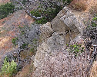
The Coldwater Sandstone is a sedimentary geologic unit of Eocene age found in Southern California, primarily in and south of the Santa Ynez Mountains of Santa Barbara County, and east into Ventura County. It consists primarily of massive arkosic sandstone with some siltstone and shale. Being exceptionally resistant to erosion, outcrops of the Coldwater form some of the most dramatic terrain on the south slope of the Santa Ynez Mountains, with immense white sculpted slabs forming peaks, hogback ridges, and sheer cliff faces.

Geology of Taiwan

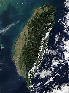
Taiwan is active geologically, formed on a complex convergent boundary between the Yangtze Subplate of the Eurasian Plate to the west and north, the Okinawa Plate on the north-east, the Philippine Plate on the east and south, and the Sunda Plate to the southwest. Subduction changes direction at Taiwan. The upper part of the crust on the island is primarily made up of a series of terranes, mostly old island arcs which have been forced together by the collision of the forerunners of the Eurasian Plate and the Philippine Sea Plate, which is moving to the northeast. These have been further uplifted as a result of the detachment of a portion of the Eurasian Plate as it was subducted beneath remnants of the Philippine Sea Plate, a process which left the crust under Taiwan more buoyant.

Hill Canyon

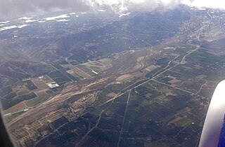
Hill Canyon is a deep canyon in the western Simi Hills and within northern Newbury Park and Thousand Oaks, in Ventura County, southern California.

The Cook Inlet Basin

The Cook Inlet Basin is a northeast-trending collisional forearc basin that stretches from the Gulf of Alaska into South central Alaska, just east of the Matanuska Valley. It is located in the arc-trench gap between the Alaska-Aleutian Range batholith and contains roughly 80,000 cubic miles of sedimentary rocks. These sediments are mainly derived from Triassic, Jurassic and Cretaceous sediments.

The geology of Virginia began to form 1.8 billion years ago and potentially even earlier. The oldest rocks in the state were metamorphosed during the Grenville orogeny, a mountain building event beginning 1.2 billion years ago in the Proterozoic, which obscured older rocks. Throughout the Proterozoic and Paleozoic, Virginia experienced igneous intrusions, carbonate and sandstone deposition, and a series of other mountain building events which defined the terrain of the inland parts of the state. The closing of the Iapetus Ocean, to form the supercontinent Pangaea added additional small landmasses, some of which are now hidden beneath thick Atlantic Coastal Plain sediments. The region subsequently experienced the rifting open of the Atlantic Ocean in the Mesozoic, the development of the Coastal Plain, isolated volcanism and a series of marine transgressions that flooded much of the area. Virginia has extensive coal, deposits of oil and natural gas, as well as deposits of other minerals and metals, including vermiculite, kyanite and uranium.

The geology of Georgia is the study of rocks, minerals, water, landforms and geologic history in Georgia. The country is dominated by the Caucasus Mountains at the junction of the Eurasian Plate and the Afro-Arabian Plate, and rock units from the Mesozoic and Cenozoic are particularly prevalent. For much of its geologic history, until the uplift of the Caucasus, Georgia was submerged by marine transgression events. Geologic research for 150 years by Georgian and Russian geologists has shed significant light on the region and since the 1970s has been augmented with the understanding of plate tectonics.

The geology of Utah includes rocks formed at the edge of the proto-North American continent during the Precambrian. A shallow marine sedimentary environment covered the region for much of the Paleozoic and Mesozoic, followed by dryland conditions, volcanism and the formation of the basin and range terrain in the Cenozoic. Utah is a state in the western United States.

The geology of Colorado was assembled from island arcs accreted onto the edge of the ancient Wyoming Craton. The Sonoma orogeny uplifted the ancestral Rocky Mountains in parallel with the diversification of multicellular life. Shallow seas covered the regions, followed by the uplift current Rocky Mountains and intense volcanic activity. Colorado has thick sedimentary sequences with oil, gas and coal deposits, as well as base metals and other minerals.

The geology of Nevada began to form in the Proterozoic at the western margin of North America. Terranes accreted to the continent as a marine environment dominated the area through the Paleozoic and Mesozoic periods. Intense volcanism, the horst and graben landscape of the Basin and Range Province originating from the Farallon Plate, and both glaciers and valley lakes have played important roles in the region throughout the past 66 million years.

The geology of Afghanistan includes nearly one billion year old rocks from the Precambrian. The region experienced widespread marine transgressions and deposition during the Paleozoic and Mesozoic, that continued into the Cenozoic with the uplift of the Hindu Kush mountains.

The geology of Israel includes igneous and metamorphic crystalline basement rocks from the Precambrian overlain by a lengthy sequence of sedimentary rocks extending up to the Pleistocene and overlain with alluvium, sand dunes and playa deposits.

The geology of Yukon includes sections of ancient Precambrian Proterozoic rock from the western edge of the proto-North American continent Laurentia, with several different island arc terranes added through the Paleozoic, Mesozoic and Cenozoic, driving volcanism, pluton formation and sedimentation.

References

  1. U.S. Geological Survey Geographic Names Information System: Simi Valley
  2. Dibblee, T.W., and Ehrenspeck, H.E., ed. Geologic map of the Santa Susana quadrangle, Ventura and Los Angeles Counties, California
  3. Darton, Nelson Horatio (1915). Guidebook of the Western United States. U.S. Government Printing Office. Pages 100-102.
  4. Blake, Thomas F. (1991). Engineering geology along the Simi-Santa Rosa Fault system and adjacent areas, Simi Valley to Camarillo, Ventura County, California: field trip guidebook : 1991 Annual Field Trip, Southern California Section, Association of Engineering Geologists, Volume 2. Association of Engineering Geologists. Pages 209-267.
  5. http://pubs.usgs.gov/of/1997/of97-259/
Digital object identifier Character string used as a permanent identifier for a digital object, in a format controlled by the International DOI Foundation

In computing, a Digital Object Identifier or DOI is a persistent identifier or handle used to identify objects uniquely, standardized by the International Organization for Standardization (ISO). An implementation of the Handle System, DOIs are in wide use mainly to identify academic, professional, and government information, such as journal articles, research reports and data sets, and official publications though they also have been used to identify other types of information resources, such as commercial videos.

JSTOR subscription digital library

JSTOR is a digital library founded in 1995. Originally containing digitized back issues of academic journals, it now also includes books and other primary sources, and current issues of journals. It provides full-text searches of almost 2,000 journals. As of 2013, more than 8,000 institutions in more than 160 countries had access to JSTOR; most access is by subscription, but some of the site's public domain and open access content is available at no cost to anyone. JSTOR's revenue was $86 million in 2015.


Coordinates: 34°16′42″N118°42′39″W / 34.27833°N 118.71083°W / 34.27833; -118.71083

Geographic coordinate system Coordinate system

A geographic coordinate system is a coordinate system that enables every location on Earth to be specified by a set of numbers, letters or symbols. The coordinates are often chosen such that one of the numbers represents a vertical position and two or three of the numbers represent a horizontal position; alternatively, a geographic position may be expressed in a combined three-dimensional Cartesian vector. A common choice of coordinates is latitude, longitude and elevation. To specify a location on a plane requires a map projection.