According to the California Protected Areas Database (CPAD), in the state of California, United States, there are over 14,000 inventoried protected areas administered by public agencies and non-profits. In addition, there are private conservation areas and other easements. [1] They include almost one-third of California's scenic coastline, including coastal wetlands, estuaries, beaches, and dune systems. The California State Parks system alone has 270 units and covers 1.3 million acres (5,300 km2), with over 280 miles (450 km) of coastline, 625 miles (1,006 km) of lake and river frontage, nearly 18,000 campsites, and 3,000 miles (5,000 km) of hiking, biking, and equestrian trails.

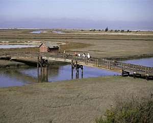
California is a state in the Pacific Region of the United States. With 39.6 million residents across a total area of about 163,696 square miles (423,970 km2), California is the most populous U.S. state and the third-largest by area. The state capital is Sacramento. The Greater Los Angeles Area and the San Francisco Bay Area are the nation's second- and fifth-most populous urban regions, with 18.7 million and 9.7 million residents respectively. Los Angeles is California's most populous city, and the country's second-most populous, after New York City. California also has the nation's most populous county, Los Angeles County, and its largest county by area, San Bernardino County. The City and County of San Francisco is both the country's second-most densely populated major city after New York City and the fifth-most densely populated county, behind only four of the five New York City boroughs.

Protected areas or conservation areas are locations which receive protection because of their recognized natural, ecological or cultural values. There are several kinds of protected areas, which vary by level of protection depending on the enabling laws of each country or the regulations of the international organizations involved.
An easement is a nonpossessory right to use and/or enter onto the real property of another without possessing it. It is "best typified in the right of way which one landowner, A, may enjoy over the land of another, B". It is similar to real covenants and equitable servitudes; in the United States, the Restatement (Third) of Property takes steps to merge these concepts as servitudes.
Contents
- National Park System
- National parks
- National monuments
- National recreation areas
- National seashores
- National preserves
- National Landscape Conservation System
- National monuments 2
- National conservation areas
- Forest reserves
- Outstanding natural areas
- National scenic and historic trails
- Wilderness and wilderness study areas
- National Marine Sanctuaries
- National Wildlife Refuges
- Hopper Mountain NWR Complex
- San Diego NWR Complex
- Humboldt Bay NWR Complex
- San Francisco Bay NWR Complex
- Kern NWR Complex
- San Luis NWR Complex
- Klamath Basin NWR Complex
- Sonny Bono Salton Sea NWR Complex
- Sacramento NWR Complex
- Other refuges
- Wild and Scenic rivers
- National Wilderness Preservation System
- National Forests
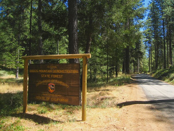
- State Forests
- State parks
- State wilderness areas
- Department of Fish and Wildlife Protected Areas
- Municipal parks
- Privately owned preserves
- Largest land owners of protected lands
- References
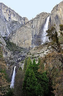
Obtaining an accurate total of all protected land in California and elsewhere is a complex task. Many parcels have inholdings, private lands within the protected areas, which may or may not be accounted for when calculating total area. Also, occasionally one parcel of land is included in two or more inventories. Over 90% of Yosemite National Park for example, is listed both as wilderness by the National Wilderness Preservation System, and as national park land by the National Park Service. The Cosumnes River Preserve is an extreme example, owned and managed by a handful of public agencies and private landowners, including the Bureau of Land Management, the County of Sacramento and The Nature Conservancy. Despite the difficulties, the CPAD gives the total area of protected land at 49,294,000 acres (199,490 km2), or 47.05% of the state (not including easements); a considerable amount for the most populous state in the country.
An inholding is privately owned land inside the boundary of a national park, national forest, state park, or similar publicly owned, protected area. In-holdings result from private ownership of lands predating the designation of the park or forest area, or the expansion of the park area to encompass the privately owned property. In the United States, the main causes of inholdings is that all of the Federal land-management agencies were formed over a century after the government sold and issued land grants to private citizens to fund the administration of the United States. When the park system was formed, many of these now-called "inholdings" had been in private ownership for generations and not available for sale when the park was formed. Over the last several decades, conservation groups have lobbied the United States Congress to acquire private residences especially within designated wilderness areas, either by direct purchase or via land exchange which trades the inholding for other federal lands located outside of national parks or wilderness areas.

The National Wilderness Preservation System (NWPS) of the United States protects federally managed wilderness areas designated for preservation in their natural condition. Activity on formally designated wilderness areas is coordinated by the National Wilderness Preservation System. Wilderness areas are managed by four federal land management agencies: the National Park Service, the U.S. Forest Service, the U.S. Fish and Wildlife Service, and the Bureau of Land Management. The term "wilderness" is defined as "an area where the earth and community of life are untrammeled by man, where man himself is a visitor who does not remain" and "an area of undeveloped Federal land retaining its primeval character and influence, without permanent improvements or human habitation, which is protected and managed so as to preserve its natural conditions." As of 2019, there are 803 designated wilderness areas, totaling 111,368,221 acres (45,069,120 ha), or about 4.5% of the area of the United States.
The National Park Service (NPS) is an agency of the United States federal government that manages all national parks, many national monuments, and other conservation and historical properties with various title designations. It was created on August 25, 1916, by Congress through the National Park Service Organic Act and is an agency of the United States Department of the Interior. The NPS is charged with a dual role of preserving the ecological and historical integrity of the places entrusted to its management while also making them available and accessible for public use and enjoyment.