Related Research Articles

The Shiawassee National Wildlife Refuge is a 9,870.35 acres (39.9439 km2) National Wildlife Refuge in Saginaw County managed by the United States Fish and Wildlife Service. It is located in the central portion of the lower peninsula of the U.S. state of Michigan, approximately 25 miles (40 km) south of the Saginaw Bay in Lake Huron and five miles (8 km) south of the city of Saginaw in the county's Spaulding and James townships. It was established in 1953 to provide habitat for migratory waterfowl.

Located in northern California, the Suisun Marsh has been referred to as the largest brackish water marsh on west coast of the United States of America. The marsh land is part of a tidal estuary, and subject to tidal ebb and flood. The marsh is home to many species of birds and other wildlife, and is formed by the confluence of the Sacramento and San Joaquin rivers between Martinez and Suisun City, California and several other smaller, local watersheds. Adjacent to Suisun Bay, the marsh is immediately west of the legally defined Sacramento-San Joaquin Delta as well as part of the San Francisco Bay estuary.
The Arrowwood National Wildlife Refuge Complex consists of numerous National Wildlife Refuges and Wetland Management Districts in the U.S. state of North Dakota. Altogether, twelve separate areas are in the complex, with the Chase Lake Prairie Project being the largest at 5.5 million acres (22,000 km2).
The San Luis National Wildlife Refuge Complex is located in the northern San Joaquin Valley, within Merced County and Stanislaus County of California. The complex, with four federal National Wildlife Refuges, is managed by the U.S Fish & Wildlife Service.

The Delevan National Wildlife Refuge is one of six refuges in the Sacramento National Wildlife Refuge Complex in the Sacramento Valley of central northern California.
Grasslands Wildlife Management Area lies within the San Joaquin River basin in California and supports the largest remaining block of wetlands in the Central Valley, containing 70,000 acres (280 km2) of private wetlands and associated, and surrounding 53,000 acres (210 km2) of state and federal lands. Perpetual conservation easements on private lands have been purchased by the United States Fish and Wildlife Service.

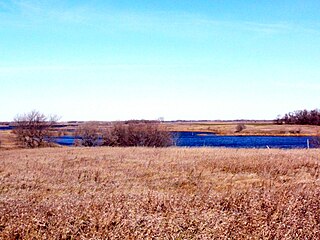
Butte Sink Wildlife Management Area is located in Colusa, Butte, and Sutter Counties. It is wetlands managed as part of the Sacramento National Wildlife Refuge Complex and is not open to the public.
Willow Creek-Lurline Wildlife Management Area is located in the Sacramento Valley of California. The landscape is very flat, bordered by the Sierra and Coast ranges and surrounded by intensive agriculture. The objective of this wildlife management area is to protect fall/winter habitat for waterfowl through the acquisition of conservation easements on privately owned wetlands. It is not open to the public.
Big Stone Wetland Management District is a protected area encompassing scattered wetlands in Lincoln and Lyon Counties, Minnesota, United States. It is operated by the U.S. Fish and Wildlife Service out of headquarters within Big Stone National Wildlife Refuge. District staff also serve private land resource interests by providing technical assistance for United States Department of Agriculture programs and restoring wetlands on private lands.
Detroit Lakes Wetland Management District is located in northwest Minnesota and includes the counties of Becker, Clay, Mahnomen, Norman, and Polk - an area of approximately 6,000 square miles (16,000 km2). The district is divided into three general landscape areas, roughly equal in size. From west to east, these are: the Red River Valley floodplain, the glacial moraine/prairie pothole region, and the hardwood/coniferous forest. The district currently manages over 42,000 acres (170 km2) of public land in 165 waterfowl production areas (WPAs). Additionally, district staff are responsible for more than 300 wetland and upland easements on private property, totaling more than 11,000 acres (45 km2).
The Fergus Falls Wetland Management District is a protected area in the U.S. state of Minnesota. It was established in 1962 with the initiation of the Accelerated Small Wetlands Acquisition Program. It is located in west central Minnesota and includes the counties of Douglas, Grant, Otter Tail, Wadena and Wilkin.
Litchfield Wetland Management District is located on the eastern edge of the Prairie Pothole Region in central Minnesota. More than 33,000 acres (130 km2) of United States Fish and Wildlife Service-owned land and 8,000 acres (32 km2) of wetland easements provide marsh, prairie, transition, and woodland habitats. District lands are located on over 150 waterfowl production areas scattered throughout seven counties. These areas vary greatly in size and vegetation and provide habitat for numerous plant and animal species.
The Minnesota Valley Wetland Management District is a fourteen-county district located in east central Minnesota, United States. It includes portions of the Minnesota, Cannon, and Mississippi River watersheds. The United States Fish and Wildlife Service works to protect the area's natural landscape through private lands habitat restorations, acquisition of waterfowl production areas (WPAs), and management of FmHA conservation easements. Since 1990, the Service has acquired 4,255 acres (17.22 km2) of WPAs and approximately 1,898 easement acres (7.68 km2). Private land restoration projects total 7,011 acres (28.37 km2) of wetland in 1,227 basins and 4,849 acres (19.62 km2) of native prairie on 223 sites.
The Morris Wetland Management District includes 244 waterfowl production areas, encompassing over 50,000 acres (200 km2) scattered throughout an eight-county area. Like other wetland management districts in the prairie states, the goal of the Morris District is to restore and protect sufficient wetland and grassland habitat to meet the needs of prairie wildlife, particularly breeding waterfowl, as well as provide places for public recreation.

The Windom Wetland Management District acquires and manages Waterfowl Production Areas, enforces wetland easements, and provides conservation assistance to landowners in 12 southwestern Minnesota counties. The landscape is dominated by intense, row-crop agriculture, which has led to the drainage of most wetlands and widespread water quality problems. Deteriorating drainage tile systems and the abundance of historic wetland basins provide unlimited opportunities for wetland restorations.
Devils Lake Wetland Management District is located in the heart of the Prairie Pothole Region of the United States. The District was established in 1962 to purchase and protect wetland habitat for migratory waterfowl and other wildlife in northeastern North Dakota. One of the primary objectives of Devils Lake Wetland Management District is to provide wetland and grassland habitat for waterfowl in the spring and summer for nesting and feeding. The other primary objective is to provide migration habitat for waterfowl in the spring and fall.
The Leopold Wetland Management District is named after Aldo Leopold, who is widely acknowledged as the father of wildlife conservation in America. Leopold is perhaps best known as the author of A Sand County Almanac, a book compiled of essays written on his farm in central Wisconsin. In tribute to his philosophy, the Leopold Wetland Management District is dedicated to preserving, restoring, and enhancing wildlife habitat in Wisconsin for the benefit of present and future generations.

The Summer Lake Wildlife Area is a 29.6-square-mile (77 km2) wildlife refuge located on the northwestern edge of the Great Basin drainage in south-central Oregon. It is administered by the Oregon Department of Fish and Wildlife. The refuge is an important stop for waterfowl traveling along the Pacific Flyway during their spring and fall migrations. The Summer Lake Wildlife Area also provides habitat for shorebirds and other bird species as well as wide variety of mammals and several fish species. The Ana River supplies the water for the refuge wetlands.
Over the past 200 years, the United States has lost more than 50% of its wetlands. And even with the current focus on wetland conservation, the US is losing about 60,000 acres (240 km2) of wetlands per year. However, from 1998 to 2004 the United States managed a net gain of 191,750 acres (776.0 km2) of wetlands . The past several decades have seen an increasing number of laws and regulations regarding wetlands, their surroundings, and their inhabitants, creating protections through several different outlets. Some of the most important have been and are the Migratory Bird Act, Swampbuster, and the Clean Water Act.
The Refuge Water Supply Program (RWSP) is administered by the United States Department of the Interior jointly by the Bureau of Reclamation and Fish and Wildlife Service and tasked with acquiring a portion and delivering a total of 555,515 acre feet (AF) of water annually to 19 specific protected wetland areas in the Central Valley of California as mandated with the passing of the Central Valley Project Improvement Act signed on October 30, 1992, by President George H. W. Bush.
References
![]() This article incorporates public domain material from websites or documents of the United States Fish and Wildlife Service .
This article incorporates public domain material from websites or documents of the United States Fish and Wildlife Service .