Ontario County was established in 1789 to govern lands the state of New York had acquired in the Phelps and Gorham Purchase; at the time it covered the entirety of Western New York. Steuben County, much larger than today, was split off from Ontario County on March 8, 1796. In 1823 a portion of Steuben County was combined with a portion of Ontario County to form Yates County. Steuben County was further reduced in size on April 17, 1854, when a portion was combined with portions of Chemung and Tompkins counties to form Schuyler County.
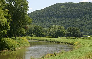
In its earliest years Steuben County was demographically and geographically linked to the Susquehanna River basin in Pennsylvania, leading to the port of Baltimore. The Canisteo River, navigable as far as Arkport, emptied into the Chemung River and it into the Susquehanna. There were no natural barriers, like the Cohoes Falls on the Mohawk, to impede transportation, and timber and other agricultural products were easily shipped downriver from what are today (2019) the towns of Addison, Canisteo, and Hornellsville. Prior to the opening of the Erie Canal in 1825, followed by the railroads, communication with the Hudson Valley and New York City was difficult. Limited to horses, mules, and donkeys, it was far too expensive to be used to ship bulky agricultural products.
In 1892 a bill was introduced in the Legislature to split Steuben County, with Canisteo, Corning, and "the south towns" becoming Lincoln County. It did not pass.[4]
According to the U.S. Census Bureau, the county has a total area of 1,404 square miles (3,640km2), of which 1,391 square miles (3,600km2) is land and 14 square miles (36km2) (1.0%) is water.[5]
Steuben County is in the southwestern part of New York State, immediately north of the Pennsylvania border. The population of Steuben County according to the 2000 U. S.census was 98,726. The county is in the Southern Tier region of New York State.
U.S. Decennial Census[12] 1790-1960[13] 1900-1990[14] 1990-2000[15] 2010-2020[2]
As of the census[16] of 2000, there were 98,726 people, 39,071 households, and 26,216 families residing in the county. The population density was 71 peopleper square mile (27 people/km2). There were 46,132 housing units at an average density of 33 unitsper square mile (13/km2). The racial makeup of the county was 96.43% White, 1.36% African American, 0.27% Native American, 0.90% Asian, 0.02% Pacific Islander, 0.21% from other races, and 0.81% from two or more races. Hispanic or Latino of any race were 0.81% of the population. 18.6% were of German, 15.2% English, 14.4% American, 13.6% Irish and 8.3% Italian ancestry according to Census 2000. 96.5% spoke English and 1.3% Spanish as their first language.
There were 39,071 households, out of which 31.80% had children under the age of 18 living with them, 51.70% were married couples living together, 10.60% had a female householder with no husband present, and 32.90% were non-families. 27.20% of all households were made up of individuals, and 11.90% had someone living alone who was 65 years of age or older. The average household size was 2.49 and the average family size was 3.01.
In the county, the population was spread out, with 26.00% under the age of 18, 7.40% from 18 to 24, 27.20% from 25 to 44, 24.20% from 45 to 64, and 15.20% who were 65 years of age or older. The median age was 38 years. For every 100 females there were 96.00 males. For every 100 females age 18 and over, there were 93.20 males.
The median income for a household in the county was $35,479, and the median income for a family was $41,940. Males had a median income of $32,155 versus $24,163 for females. The per capita income for the county was $18,197. About 9.90% of families and 13.20% of the population were below the poverty line, including 18.70% of those under age 18 and 5.80% of those age 65 or over.
The largest employer in Steuben County is Corning, Inc. (formerly Corning Glass Works), the world headquarters of a large firm (34,000 employed worldwide) which manufactures specialty glass and related products. Related is the nearby Corning Museum of Glass. There is a wine industry in Hammondsport, also the headquarters of the Mercury Corporation, a custom manufacturer, formerly of aircraft and aircraft components. There is a museum of aviation, the Glenn H. Curtiss Museum, in Hammondsport. Former industries in Steuben County are the Steuben Glass Works, in Corning, now part of Corning Glass Works, and the Erie Railroad repair shops, in Hornell.
↑ W, Eric (April 2, 2012). "Congressional District 23"(PDF). View 2012 Congressional Maps. Albany, New York: The New York State Legislative Task Force on Demographic Research and Reapportionment. Retrieved January 13, 2013.
↑ W, Eric (March 2, 2012). "Senate District 58"(PDF). View 2012 Senate District Maps. Albany, New York: The New York State Legislative Task Force on Demographic Research and Reapportionment. Retrieved January 17, 2013.
↑ W, Eric (January 25, 2012). "Assembly District 132"(PDF). View 2012 Assembly District Maps. Albany, New York: The New York State Legislative Task Force on Demographic Research and Reapportionment. Retrieved January 17, 2013.
↑ W, Eric (January 25, 2012). "Assembly District 133"(PDF). View 2012 Assembly District Maps. Albany, New York: The New York State Legislative Task Force on Demographic Research and Reapportionment. Retrieved January 17, 2013.
↑ W, Eric (January 25, 2012). "Assembly District 148"(PDF). View 2012 Assembly District Maps. Albany, New York: The New York State Legislative Task Force on Demographic Research and Reapportionment. Retrieved January 17, 2013.
Sherer, Richard, (ed.) Steuben County: The First 200 Years, A Pictorial History. Virginia Beach, VA: The Donning Company, 1996.
Stromquist, Shelton, "'Our Rights as Workingmen': Class Traditions and Collective Action in a Nineteenth-Century Railroad Town, Hornellsville, New York, 1869-82," in David O. Stowell (ed.), The Great Strikes of 1877. Urbana, IL: University of Illinois Press, 2008; pp.55–75.
Chemung County is a county in the U.S. state of New York. The population was 84,148 as of the 2020 census. Its county seat is Elmira. Its name is derived from a Delaware Indian village whose name meant "big horn". The county is part of the Southern Tier region of the state.
Ontario County is a county in the U.S. State of New York. As of the 2020 census, the population was 112,458. The county seat is Canandaigua. The county is part of the Finger Lakes region of the state.
Niagara County is in the U.S. state of New York. As of the 2020 census, the population was 212,666. The county seat is Lockport. The county name is from the Iroquois word Onguiaahra; meaning the strait or thunder of waters. The county is part of the Western New York region of the state.
Schuyler County is a county in the U.S. state of New York. As of the 2020 census, the population was 17,898, making it the second-least populous county in New York. The county seat is the village of Watkins Glen. The name is in honor of General Philip Schuyler, one of the four major generals in the Continental Army in the American Revolutionary War. The county is part of the Southern Tier region of the state.
Arkport is a village in Steuben County, New York, United States. It is located in the town of Hornellsville, and is north of the city of Hornell. The population was 844 at the 2010 census. The name comes from the barges used to ship products through the village. The postal code is 14807.
Fremont is a town in Steuben County, New York, United States. The population was 898 at the 2020 census. The town is named after General John Fremont.
Hornell is a city in Steuben County, New York, United States. The population was 8,259 at the 2020 census. The city is named after the Hornell family, early settlers.
Hornellsville is a town in Steuben County, New York, United States. The population, not counting the city of Hornell, was 4,039 at the 2020 census. The name is taken from a prominent pioneer family.
North Hornell is a village in Steuben County, New York, United States. The population was 778 at the 2010 census. The village is entirely within the town of Hornellsville, north of the city Hornell.
Canisteo is a village in Steuben County, New York, United States. The population was 2,176 at the 2020 census.
Canisteo is a town in Steuben County, New York, United States. The population was 3,294 at the 2020 census. The name was taken from a former Native American village located there, and is Iroquoian in origin.
Corning is a city in Steuben County, New York, United States, on the Chemung River. The population was 10,551 at the 2020 census. It is named for Erastus Corning, an Albany financier and railroad executive who was an investor in the company that developed the community. The city is best known as the headquarters of Fortune 500 company Corning Incorporated, formerly Corning Glass Works, a manufacturer of glass and ceramic products for industrial, scientific and technical uses. Corning is roughly equidistant from New York City and Toronto, being about 220 miles (350 km) from both.
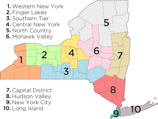
The Southern Tier is a geographic subregion of the broader Upstate region of New York State, geographically situated along or very near the state border with Pennsylvania. Definitions of the region vary widely, but generally encompass counties surrounding the Binghamton and Elmira-Corning metropolitan areas. This region is adjacent to the Northern Tier of Pennsylvania, and both these regions together are known as the Twin Tiers.
The Canisteo River is a 61.0-mile-long (98.2 km) tributary of the Tioga River in western New York in the United States. It drains a dissected plateau, a portion of the northern Allegheny Plateau southwest of the Finger Lakes region, in the far northwestern reaches of the watershed of the Susquehanna River.
New York State Route 36 (NY 36) is a north–south state highway in the western part of New York in the United States. The highway extends for 95 miles (153 km) from the Pennsylvania state line at Troupsburg, Steuben County northward to Ogden, Monroe County, where it ends at an intersection with NY 31. Along the way, NY 36 passes through the villages of Canisteo, Dansville, Mount Morris, Caledonia, and Churchville and the city of Hornell. The section of the route between Dansville and Mount Morris closely parallels Interstate 390 (I-390); however, from Dansville south and Mount Morris north, NY 36 serves as a regionally important highway, connecting to I-86, U.S. Route 20A (US 20A), US 20, and I-490 as it heads north. At its south end, NY 36 connects to Pennsylvania Route 249 (PA 249).
The Evening Tribune is an American daily newspaper published weekday mornings and on Sundays in Hornell, New York.
The Liberty Highway was an auto trail in the United States linking New York City with Cleveland, Ohio. It passed through Binghamton, New York; Elmira, New York; Jamestown, New York; and Erie, Pennsylvania. First signed in 1918, it was named after the village of Liberty, New York.
The Hornell Traction Company was an electric streetcar company serving Hornell and Canisteo, New York, between 1892 and 1926.
The McBurney House is the oldest surviving house in Steuben County, New York. It is located at 5872 Dineen Road, between the village of Canisteo and the city of Hornell, in the town of Hornellsville, New York. It is served by the Canisteo post office.
Herman Emerson Buck was an American businessman and politician from New York.
This page is based on this Wikipedia article Text is available under the CC BY-SA 4.0 license; additional terms may apply. Images, videos and audio are available under their respective licenses.