
Shivneri Fort is an ancient military fortification located near Junnar in Pune district in Maharashtra, India. It is the birthplace of Shivaji, the founder of Maratha Empire.

Sinhagad is an ancient hill fortress located at around 49 km southwest of the city of Pune, India.
Wai is a town in Satara district of Maharashtra state in India. Located on the Krishna River, Wai was a prominent town during the Peshwa era. Two important Marathi Brahmin from ruling families had their origins here: Rani Lakshmibai of Jhansi and Gopikabai, wife of Nanasaheb Peshwa.

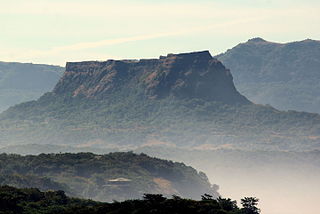
Tikona also known as Vitandgad, is the dominant hill fort in Maval in western India. It is located near Kamshet around 60 km from Pune. The village nearest to the fort is called Tikona-Peth. The 3500 foot high hill is pyramidal in shape and the name Tikona means "triangular".

Kolaba Fort located at Alibag beach is an old fortified maritime base in Alibag, Konkan, India. It is situated in the sea at a distance of 1–2 km from the shores of Alibag, 35 km south of Mumbai, in the Konkan region of Maharashtra, India. It is a popular tourist destination and a protected monument.
Sudhagad / Bhorapgad is a hill fort situated in Maharashtra, India. It lies about 53 kilometres (33 mi) west of Pune, 26 kilometres (16 mi) south of Lonavla and 11 kilometres (6.8 mi) east of Pali in Raigad District. The summit is 620 metres (2,030 ft) above sea level. The entire area around the fort is declared a Sudhagad wildlife sanctuary.
Raireshwar fort is in Bhor taluka near Pune, India, 82 km (51 mi) away. It is between various hills and forts such as Kenjalgad. In the Maratha Empire age it was a significant fort.

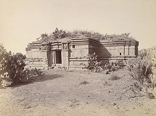
Torna Fort, also known as Prachanda gad, is a large fort located in Pune district, in the Indian state of Maharashtra. It is historically significant because it was the first fort captured by Shivaji I in 1646, at the age of 16. The hill has an elevation of 1,403 metres (4,603 ft) above sea level, making it the highest hill-fort in the district. The name derives from Prachanda and gad.

Purandar Fort is a mountain fort in Pune district in Western Indian state of Maharashtra, India. The fort stands at 1,374 metres (4,508 ft) above the sea level in the Western Ghats, 50 kilometres (31 mi) to the southeast of Pune.
Korigad is a hill fort located about 20 km (12 mi) south of Lonavla in Pune district, Maharashtra, India. Its date of construction is not known but likely predates 1500. It is about 923 m above sea level. The planned township of Aamby Valley is built over the fort's southern and eastern foothills. The closest village is Peth Shahpur, about 1 km (0.62 mi) north of the fort.
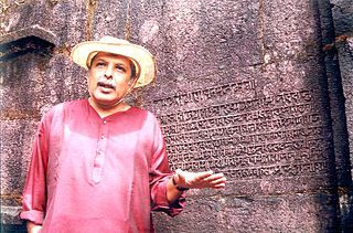
Ninad Gangadhar Bedekar was a historian, writer and orator from Pune, Maharashtra, India, writing and speaking in Marathi. He was specialized in research of the rule of warrior-king Chatrapati Shivaji Maharaj and was known for his scientific and scholarly approach to the subject of Maratha history.

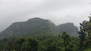
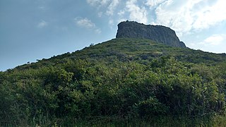
Kenjalgad Fort in Wai, Maharashtra is a fort eleven miles (18 km) north-west of Wai. It is located on the Mandhardev spur of the Mahadev hill range. The fort is visible from quite a long distance as a stone scarp 30–40 feet high rising as a cap on the irregular hill. The fort is rhomboid in shape with 388m long axis and 175m short axis.
Banawadi is a census village of Satara district in the Indian state of Maharashtra. It is situated near to the Satara Phaltan state highway, about 21 km north of Satara, about 108 km from Pune and 220 km from Mumbai.

Ghangad is a fort situated near 30km from Lonavla-Khandala and 100 km from Pune in Maharashtra state, India.This fort is an important fort in the Pune district. The fort restoration is done by the Shivaji Trail group with the help of local villagers. The fort is at least 300 years old. Restoration work took place in 2011-12.

Vandan Fort is located in Satara District. This fort is situated on a hilly spur from the main ridge of Sahyadri. This fort is frequently visited by trekkers and pilgrims. The villages at the base are rich in sugarcane and other cultivation. The Chandan and Vandan are adjacent forts. The trek to both the fort can easily be completed in a day.
Indrai Fort / Indragiri Fort is a fort located 75 km from Nashik, in Nashik district, of Maharashtra. This fort though is an important fort in Nashik district but, it is less visited by the trekkers. In Chandwad taluka, there are 4 forts in a line on the Satmal hill range, the Chandwad fort, Indrai fort, Rajdher fort, and Koldher fort. This fort is easy to climb but requires 3 hours to reach the fort.
Makrandgad Fort is a fort near Pratapgad Fort. It is located 156km from Pune, in Satara district, of Maharashtra. The fort is located in the midst of the famous Javli forest. The fort is accessible from the Hatlot and Ghonaspur village. The trek to this fort is an easy one day trek for visitors at Mahabaleshwar. The fort consists of two flattened humps with a ridge between them.
Trymbakgad Fort/Brahmagiri Fort is a fort located 30 km from Nashik, in Nashik district, of Maharashtra, India. This is an important fort in Nashik district. It is located on a hill adjoining the famous Trimbakeshwar temple.
Bahadurgad is a fort in the Pedgaon village of Ahmednagar district in Maharashtra, India.


