Old Town (Franklin, Tennessee)

Last updated
Old Town Archaeological Site
(40WM2)
Old Town Archaeological Site map HRoe 2011.jpg
Diagram of placement of mounds and works at the Old Town Archaeological Site
USA Tennessee location map.svg
Archaeological site icon (red).svg
Location in Tennessee today
Location Franklin, Tennessee,  Williamson County, Tennessee, Flag of the United States.svg  USA
Region Williamson County, Tennessee
Coordinates 35°59′38.44″N86°56′11.36″W / 35.9940111°N 86.9364889°W / 35.9940111; -86.9364889
History
Cultures Mississippian culture
Site notes
Architecture
Architectural styles platform mounds, plaza
Architectural detailsNumber of temples:
Old Town Archaeological Site
Old Town Archeological Site.JPG
Old Town Archeological Site, October 2014.
USA Tennessee location map.svg
Red pog.svg
Nearest city Franklin, Tennessee
Area41 acres (17 ha)
MPS Mississippian Cultural Resources of the Central Basin MPS (40WM2)
NRHP reference No. 89000159 [1]
Added to NRHP1989
Responsible body: State

Old Town is an archaeological site in Williamson County, Tennessee near Franklin. The site includes the remnants of a Native American village and mound complex of the Mississippian culture, and is listed on the National Register of Historic Places (NRHP) as Old Town Archaeological Site (40WM2). [1]

Contents

Background

Since the early days of settlement in Middle Tennessee, the "Old Town on the Big Harpeth River" has been a critical component of a common understanding of the area's prehistory. [2] :26 The earliest archaeological investigations of the site were in 1868 by physician Joseph Jones, [3] who was then Nashville's municipal health officer; his efforts were largely frustrated because much of the site's most significant mound was occupied by the owner's wife's flower garden, but he was able to find a frog effigy from part of the mound outside the garden. [2] :29 W.M. Clark mentioned the location in an 1878 publication, [2] :32 but no more substantial excavations were conducted until 1928: while building a bridge over Brown Creek at its confluence with the river, Williamson County road crews accidentally dug into a large burial ground, and a local man worked hard to record as much information about the site as possible. Since the late twentieth century, no substantial excavations have been conducted, but the owners have permitted the recovery of artifacts from small portions of the site when construction has demanded work on the periphery; among this work has been a project to place a water pipeline in 1984 and the 1991 renovation of the Thomas Brown House on the property. [2] :33

Site description

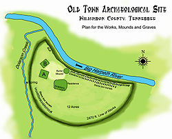
The Mississippian culture village and mound complex is located at the confluence of the Harpeth River and Dolorson Creek on the Harpeth River branch of the Natchez Trace. Archaeological investigations of the 12-acre (4.9 ha) site have uncovered artifacts dating from approximately 900 to 1450. In his book Aboriginal Remains of Tennessee, published by the Smithsonian Institution in 1876, Joseph Jones produced a detailed account of the site. [3] [4] The village area was surrounded by steep earthworks running in a 2,470 feet (750 m) semicircle, [5] portions of which were topped by a wooden palisade that is interpreted as having been intended as a protective fortification. Within the enclosure, the village area includes several large earthen mounds [4] [5] a plaza and associated village areas. Jones described the mound grouping as including two platform mounds and two burial mounds. [4] [5] Mississippian mound complexes such as the Old Town complex are thought to have been regional centers for civic and ceremonial activity, as well as serving as the permanent residences of ruling elites. [3] The mounds are located within the embankments. The largest of the rectangular platform mounds, Mound A, was 112 feet (34 m) on its longer side by 65 feet (20 m) on the shorter side and 11 feet (3.4 m) in height. The second, Mound B, was 70 feet (21 m) by 65 feet (20 m) at its base and 9 feet (2.7 m) in height. Located across a plaza area was a 30 feet (9.1 m) by 20 feet (6.1 m) in diameter 2.5 feet (0.76 m) high burial mound. [5] The remaining burial mound is the location of the Thomas Brown House.

In 1984 and 1991, the Tennessee Division of Archaeology conducted brief salvage excavations at the Old Town site in anticipation of construction and renovation projects. The artifacts collected allowed researchers to place Old Town's primary period of habitation at between 1250 and 1450. Radiocarbon dating of charcoal uncovered from a prehistoric trash pit returned a date of 1214. [6]

Stone box graves

A stone box grave with the body in the flexed position FlexedSkeleton.jpg
A stone box grave with the body in the flexed position

Burials at the site were of a type known as stone box graves. Jones opened up at least 50 examples during his investigations. [4] In this type of burial, which was commonly used by Mississippian people in the central basin of Middle Tennessee, the dead were interred in shallow rectangular excavations lined with large thin slabs of limestone. A "nearly form-fitting" pit was dug to hold the person's remains, the bottom and sides were lined with appropriately sized rock slabs, the person's remains were laid inside, and the resulting box was covered with another stone slab. [3] [7] [8] Most of these individual graves were located along the banks of the river and creek. [4]

NRHP sites at location

A larger, 41-acre (17 ha), area was listed as the "Old Town Archaeological Site" on the National Register in 1989 as part of the Mississippian Cultural Resources of the Central Basin (900 to 1450) Multiple Property Submission. [1] [3] [4] "Old Town" also is a name given to the Thomas Brown House, built nearby to the mound complex site in the 1840s or 1850s, [9] "Old Town" is also reflected in the name of the nearby Old Town Bridge that carried the Harpeth River branch of the Natchez Trace over Brown's Creek. [4]

See also

Related Research Articles

Harpeth River

The Harpeth River, 115 miles (185 km) long, is one of the major streams of north-central Middle Tennessee, United States, and one of the major tributaries of the Cumberland River. Via the Cumberland and the Ohio Rivers, it is part of the Mississippi River watershed. The lower portion of the Harpeth is designated as a "scenic river" under the Tennessee Scenic Rivers Act.

Etowah Indian Mounds United States historic place

Etowah Indian Mounds (9BR1) are a 54-acre (220,000 m2) archaeological site in Bartow County, Georgia south of Cartersville, in the United States. Built and occupied in three phases, from 1000–1550 AD, the prehistoric site is located on the north shore of the Etowah River.

Pinson Mounds Archaeological park

The Pinson Mounds comprise a prehistoric Native American complex located in Madison County, Tennessee, in the region that is known as the Eastern Woodlands. The complex, which includes 17 mounds, an earthen geometric enclosure, and numerous habitation areas, was most likely built during the Middle Woodland period. The complex is the largest group of Middle Woodland mounds in the United States. Sauls' Mound, at 72 feet (22 m), is the second-highest surviving mound in the United States.

Mississippian culture Mound-building Native American culture in Midwestern, Eastern, and Southeastern United States

The Mississippian culture was a Native American civilization that flourished in what is now the Midwestern, Eastern, and Southeastern United States from approximately 800 CE to 1600 CE, varying regionally. It was known for building large, earthen platform mounds, and often other shaped mounds as well. It was composed of a series of urban settlements and satellite villages (suburbs) linked together by loose trading networks. The largest city was Cahokia, believed to be a major religious center located in what is present-day southern Illinois.

Mound Builders Pre-Columbian cultures of North America that constructed various styles of earthen mounds

A number of pre-Columbian cultures are collectively termed "Mound Builders". The term does not refer to a specific people or archaeological culture, but refers to the characteristic mound earthworks erected for an extended period of more than 5,000 years. The "Mound builder" cultures span the period of roughly 3500 BCE to 1600 CE, including the Archaic period, Woodland period, and Mississippian period. The construction of Watson Brake) to the 16th century CE, and living in regions of the Great Lakes, the Ohio River Valley, and the Mississippi River valley and its tributary waters.

Winterville Site Archaeological site in Washington County, Mississippi, United States

The Winterville Site is a major archaeological site in unincorporated Washington County, Mississippi, north of Greenville and along the river. It consists of major earthwork monuments, including more than twelve large platform mounds and cleared and filled plazas. It is the type site for the Winterville Phase of the Lower Yazoo Basin region of the Plaquemine Mississippian culture. Protected as a state park, it has been designated as a National Historic Landmark.

Mound Bottom United States historic place

Mound Bottom is a prehistoric Native American complex in Cheatham County, Tennessee, located in the Southeastern United States. The complex, which consists of earthen platform and burial mounds, a 7-acre central plaza, and habitation areas, was occupied between approximately 1000 and 1300 AD, during the Mississippian period.

Toqua (Tennessee) Prehistoric Native American site in Monroe County, Tennessee, United States

Toqua was a prehistoric and historic Native American site in Monroe County, Tennessee, located in the Southeastern Woodlands. Toqua was the site of a substantial ancestral town that thrived during the Mississippian period (1000-1600CE). Toqua had a large earthwork 25-foot (7.6 m) platform mound built by the town's Mississippian-era inhabitants, in addition to a second, smaller mound. The site's Mississippian occupation may have been recorded by the Spanish as the village of Tali, which was documented in 1540 by the Hernando de Soto expedition. It was later known as the Overhill Cherokee town Toqua, and this name was applied to the archeological site.

Tomotley United States historic place

Tomotley is a prehistoric and historic Native American site along the lower Little Tennessee River in Monroe County, Tennessee, in the southeastern United States. Occupied as early as the Archaic period, the Tomotley site was occupied particularly during the Mississippian period, which was likely when its earthwork platform mounds were built. It was also occupied during the eighteenth century as a Cherokee town. It revealed an unexpected style: an octagonal townhouse and square or rectangular residences. In the Overhill period, Cherokee townhouses found in the Carolinas in the same period were circular in design, with,

Plaquemine culture

The Plaquemine culture was an archaeological culture centered on the Lower Mississippi River valley. It had a deep history in the area stretching back through the earlier Coles Creek and Troyville cultures to the Marksville culture. The Natchez and related Taensa peoples were their historic period descendants. The type site for the culture is the Medora Site in Louisiana; while other examples include the Anna, Emerald, Holly Bluff, and Winterville sites in Mississippi.

This is a list of the National Register of Historic Places listings in Williamson County, Tennessee.

Boyd Mounds Site

The Boyd Mounds Site (22MD512) is an archaeological site from the Late Woodland and Early Mississippian period located in Madison County, Mississippi near Ridgeland. Many of the mounds were excavated by The National Park Service in 1964. It is located at mile 106.9 on the old Natchez Trace, now the Natchez Trace Parkway. It was added to the NRHP on July 14, 1989 as NRIS number 89000784.

Garden Creek site

Garden Creek site is an archaeological site located 24 miles (39 km) west of Asheville, North Carolina in Haywood County, on the south side of the Pigeon River and near the confluence of its tributary Garden Creek. It is near modern Canton and the Pisgah National Forest. The earliest human occupation at the site dates to 8000 BCE.

Thomas Brown House (Franklin, Tennessee) United States historic place

Old Town, also known as the Thomas Brown House, is a house in Franklin, Tennessee, United States, at the Old Town Archeological Site that was built by Thomas Brown starting in 1846. It is a two-story frame structure built on an "I-House" plan, an example of vernacular architecture showing Greek Revival influences. The Thomas Brown House is among the best two-story vernacular I-house examples in the county.

Castalian Springs Mound Site

The Castalian Springs Mound State Historic Site (40SU14) is a Mississippian culture archaeological site located near the small unincorporated community of Castalian Springs in Sumner County, Tennessee. The site was first excavated in the 1890s and again as recently as the 2005 to 2011 archaeological field school led by Dr. Kevin E. Smith. A number of important finds have been associated with the site, most particularly several examples of Mississippian stone statuary and the Castalian Springs shell gorget held by the National Museum of the American Indian. The site is owned by the State of Tennessee and is a State Historic Site managed by the Bledsoe's Lick Association for the Tennessee Historical Commission. The site is not currently open to the public.

Beasley Mounds Site

The Beasley Mounds Site (40SM43) is a Mississippian culture archaeological site located at the confluence of Dixon Creek and the Cumberland River near the unincorporated community of Dixon Springs in Smith County, Tennessee. The site was first excavated by amateur archaeologists in the 1890s. More examples of Mississippian stone statuary have been found at the site than any other in the Middle Tennessee area. The site was listed on the National Register of Historic Places in 2010.

Brick Church Mound and Village Site

The Brick Church Mound and Village Site (40DV39) is a Mississippian culture archaeological site located in Nashville in Davidson County, Tennessee. It was excavated in the late nineteenth century by Frederic Ward Putnam. During excavations in the early 1970s the site produced a unique cache of ceramic figurines very similar in style to Mississippian stone statuary which are now on display at the Frank H. McClung Museum. It was added to the National Register of Historic Places (NRHP) on May 7, 1973 as NRIS number 73001759 although this did not save the site from being almost totally destroyed by residential development.

Stone box grave

Stone box graves were a method of burial used by Native Americans of the Mississippian culture in the American Midwest and Southeast. Their construction was especially common in the Cumberland River Basin, in settlements found around present-day Nashville, Tennessee.

Fewkes Group Archaeological Site

Fewkes Group Archaeological Site, also known as the Boiling Springs Site, is a pre American history Native American archaeological site located in the city of Brentwood, in Williamson County, Tennessee. It is in Primm Historic Park on the grounds of Boiling Spring Academy, a historic schoolhouse established in 1830. The 15-acre site consists of the remains of a late Mississippian culture mound complex and village roughly dating to 1050-1475 AD. The site, which sits on the western bank of the Little Harpeth River, has five mounds, some used for burial and others, including the largest, were ceremonial platform mounds. The village was abandoned for unknown reasons around 1450. The site is named in honor of Dr. J. Walter Fewkes, the Chief of the Bureau of American Ethnology in 1920, who had visited the site and recognized its potential. While it was partially excavated by the landowner in 1895, archaeologist William E. Myer directed a second, more thorough excavation in October 1920. The report of his findings was published in the Bureau of American Ethnology's Forty-First Annual Report. Many of the artifacts recovered from the site are now housed at the Smithsonian Institution. It was added to the National Register of Historic Places on April 21, 1980, as NRIS number 80003880.

Brentwood Library Site

The Brentwood Library Site (40WM210), also known as the Jarman Farm Site, is a Mississippian culture archaeological site located in the city of Brentwood, in Williamson County, Tennessee. The substantial town was occupied during Regional Period IV of the local Mississippian chronology, and there was an associated burial ground, where nearly 50 stone box graves have been found. Artifacts from the site have been radiocarbon dated to between 1298 to 1465 CE. These include several types of Mississippian pottery, with Beckwith Incised found in the highest number.

References

  1. 1 2 3 "National Register Information System". National Register of Historic Places . National Park Service. March 13, 2009.
  2. 1 2 3 4 Smith, Kevin E. "Archaeology at Old Town [40Wm2]: A Mississippian Mound-Village Center in Williamson County, Tennessee". Tennessee Anthropologist 18.1 (1993): 27-44.
  3. 1 2 3 4 5 Tennessee Historical Commission, Mississippian Cultural Resources of the Central Basin (A.D. 900 to A.D. 1450) Multiple Property Submission, January 31, 1989
  4. 1 2 3 4 5 6 7 Kelly McGuinness, Old Town, FranklinIs.com website, accessed April 13, 2011
  5. 1 2 3 4 Thruston, Gates Phillips (1890). The antiquities of Tennessee and the adjacent states, and the state of aboriginal society in the scale of civilization represented by them: A series of historical and ethnological studies. The R. Clarke Company. pp.  39–40.
  6. Kevin Smith, "Archaeology at Old Town (40WM2): A Mississippian Mound-Village Center in Williamson County, Tennessee," Tennessee Anthropologist, Vol. XVIII, no. 1 (Spring 1993), pp. 27-44.
  7. Kelly McGuinness, Stone Box Indian Site, FranklinIs.com website, accessed April 2, 2010
  8. Nashville's Native American History: Noel Creek Cemetery, Native Nashville website, accessed April 2, 2010
  9. The Williamson County MRA gives a date of 1842; NRIS gives the date as 1846; McGuinness gives the date as "circa 1854."

Further reading