Pennsylvania's 13th congressional district | |
---|---|
Interactive map of district boundaries since January 3, 2023 | |
Representative | |
Population (2023) | 765,875 |
Median household income | $64,789 |
Ethnicity |
|
Cook PVI | R+25 [1] |
The 13th congressional district of Pennsylvania is a congressional district in the U.S. state of Pennsylvania. The district contains all of Adams, Bedford, Blair, Cambria, Franklin, Fulton, Huntingdon, Juniata, Mifflin, and Perry counties. It also includes slivers of Cumberland and Somerset counties. Republican John Joyce has represented the district since 2019. With a Cook Partisan Voting Index rating of R+25, it is the most Republican district in Pennsylvania. [1]
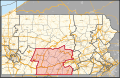
Prior to February 2018, the district was located in southeastern Pennsylvania, covering eastern Montgomery County and Northeast Philadelphia. The district traditionally included most of Montgomery County, but was redrawn in 2002 to include part of Philadelphia, and altered again in 2012. The Supreme Court of Pennsylvania redrew the district in February 2018 after ruling the previous map unconstitutional. The old 13th district became the 4th district, and what was the ninth district in the southwest part of the state was modified and redesignated the 13th district, for the 2018 elections and representation thereafter. [2]
The previously drawn district had long been a Republican stronghold, like many suburban districts in the Northeast. However, the brand of Republicanism in southeastern Pennsylvania was a moderate one, and the district, like the Philadelphia suburbs as a whole, became friendlier to Democrats during the 1990s as the national party veered to the right. The district had not voted Republican for president since 1988. In 1992, the district elected its first Democratic representative in 86 years, Marjorie Margolies-Mezvinsky. She was defeated in 1994 by Republican Jon D. Fox, but Joe Hoeffel regained the seat for the Democrats in 1998. It was in Democratic hands afterward, becoming even more Democratic after being pushed into Philadelphia after the 2000 census. In 2018, it was redistricted again by court order, becoming the most Republican congressional district in the Northeast.
As of the census [3] of 2000, there were 647,435 people, 250,845 households, and 169,848 families residing in the district. The racial makeup of the district was 87.16% White, 6.05% Black or African American, 0.14% Native American, 4.05% Asian, 0.00% Pacific Islander, 1.32% from other races, and 1.24% from two or more races. 3.06% of the population were Hispanic or Latino of any race.
There were 250,845 households, out of which 30.4% had children under the age of 18 living with them, 53.3% were married couples living together, 10.8% had a female householder with no husband present, and 32.3% were non-families. 27.9% of all households were made up of individuals, and 12.6% had someone living alone who was 65 years of age or older. The average household size was 2.51, and the average family size was 3.09.
In the district, the population was spread out, with 23.5% under the age of 18, 7.1% from 18 to 24, 29.2% from 25 to 44, 22.9% from 45 to 64, and 17.3% who were 65 years of age or older. The median age was 39 years. For every 100 females there were 92.0 males. For every 100 females age 18 and over, there were 88.2 males.
The median income for a household in the district was $49,319, and the median income for a family was $61,108. Males had a median income of $36,441 versus $23,719 for females. The per capita income for the district was $25,053. About 5.1% of families and 7.1% of the population were below the poverty line, including 6.8% of those under age 18 and 8.5% of those age 65 or over.
Year | Office | Results [4] |
---|---|---|
2008 | President | McCain 61% - 37% |
2012 | President | Romney 67% - 33% |
2016 | President | Trump 71% - 25% |
Senate | Toomey 67% - 27% | |
Attorney General | Rafferty Jr. 68% - 32% | |
Treasurer | Voit III 62% - 31% | |
Auditor General | Brown 62% - 31% | |
2018 | Senate | Barletta 64% - 34% |
Governor | Wagner 63% - 35% | |
2020 | President | Trump 72% - 27% |
Attorney General | Heidelbaugh 69% - 28% | |
Treasurer | Garrity 71% - 26% | |
Auditor General | DeFoor 72% - 24% | |
2022 | Senate | Oz 68% - 29% |
Governor | Mastriano 64% - 34% |
Adams County (34)
Bedford County (38)
Blair County (25)
Cambria County (63)
CumberlandCounty (22)
Franklin County (22)
Fulton County (13)
Huntingdon County (48)
Juniata County (17)
Mifflin County (16)
PerryCounty (30)
Bedford County is a county in the Commonwealth of Pennsylvania. As of the 2020 census, the population was 47,577. The county seat is Bedford. The county is part of the Southwest Pennsylvania region of the state.
Juniata County is a county in the Commonwealth of Pennsylvania. As of the 2020 census, the population was 23,509. Its county seat is Mifflintown. The county was created on March 2, 1831, from part of Mifflin County and named for the Juniata River. The county is part of the Central Pennsylvania region of the state.
Huntingdon County is a county in the Commonwealth of Pennsylvania. As of the 2020 census, the population was 44,092. Its county seat is Huntingdon. The county was created on September 20, 1787, mainly from the northern part of Bedford County, plus an addition of territory on the east from Cumberland County. The county is part of the Southwest Pennsylvania region of the state.
Fulton County is a county in the Commonwealth of Pennsylvania. As of the 2020 census, the population was 14,556, making it the fourth-least populous county in Pennsylvania. Its county seat is McConnellsburg. The county was created on April 19, 1850, from a part of Bedford County and named after inventor Robert Fulton. The county is part of the Southwest Pennsylvania region of the state.
Franklin County is a county in the Commonwealth of Pennsylvania. As of the 2020 census, the population was 155,932. Its county seat is Chambersburg.
Blair County is a county in the Commonwealth of Pennsylvania. As of the 2020 census, the population was 122,822. Its county seat is Hollidaysburg, and its largest city is Altoona. The county was created on February 26, 1846, from parts of Huntingdon and Bedford counties. The county is part of the Southwest Pennsylvania region of the state.
Juniata Township is a township in Blair County, Pennsylvania, United States. It is part of the Altoona, PA Metropolitan Statistical Area. The population was 965 at the 2020 census.
Snyder Township is a township in Blair County, Pennsylvania, United States. It is part of the Altoona, PA Metropolitan Statistical Area. The population was 3,345 at the 2020 census.
Shippensburg Township is a township in Cumberland County, Pennsylvania, United States, adjacent to the borough of Shippensburg. The population of the township was 5,429 at the 2010 census, up from 4,504 at the 2000 census. The township is the location of the majority of the property of Shippensburg University of Pennsylvania.
Fannett Township is a township in Franklin County, Pennsylvania, United States. The population was 2,483 at the 2020 census. The township derives its name as an older variant spelling of Fanad, County Donegal, from early Irish settlement in the area. It was formed before 1762, and until about 1795 included the area now in Metal Township.
Southampton Township is a township that is located in Franklin County, Pennsylvania, United States. The population was 8,566 at the time of the 2020 census, an increase from the figure of 6,138 that was documented by the 2000 census.
Huntingdon is a borough in and county seat of Huntingdon County, Pennsylvania, in the Middle Atlantic states region of the Northeastern United States. It is located along the Juniata River, approximately 32 miles (51 km) east of larger Altoona and 92 miles (148 km) west of the state capital of Harrisburg on the Susquehanna River. With a population of 6,827 in the 2020 U.S. Decennial Census, it is the largest population center near Raystown Lake, a winding, 28-mile-long (45 km) flood-control reservoir managed by the United States Army Corps of Engineers.
Mill Creek is a borough in Huntingdon County, Pennsylvania, United States. The population was 328 at the 2010 census.
Penn Township is a township in Huntingdon County, Pennsylvania, United States. The population was 1,078 at the 2020 census. The township includes the village of Hesston and the Seven Points Marina of Raystown Lake.
Lack Township is a township that is located in Juniata County, Pennsylvania, United States. The population was 637 at the time of the 2020 census.
McHenry Township is a township in Lycoming County, Pennsylvania, United States. The population was 121 at the 2020 census. It is part of the Williamsport Metropolitan Statistical Area.
McVeytown is a borough in Mifflin County, Pennsylvania, United States, on the west bank of the Juniata River. Formerly known as Waynesburg, it was settled in 1762, laid out in 1795, and incorporated in 1833. The population was 344 at the 2020 census. The "Father of Pennsylvania Forestry", Dr. Joseph Rothrock was born in McVeytown on April 9, 1839. He was largely responsible for the acquisition of the lands that became Pennsylvania state parks and forests, including Rothrock State Forest.
Menno Township is a township in Mifflin County, Pennsylvania, United States. The population was 1,973 at the time of the 2020 census.
Newton Hamilton is a borough in Mifflin County, Pennsylvania, United States. The population was 197 at the time of the 2020 census.
Cumberland County is a county in the Commonwealth of Pennsylvania. As of the 2020 census, the population was 259,469. Its county seat is Carlisle. The county is part of the South Central Pennsylvania region of the state. Cumberland County is included in the Harrisburg–Carlisle metropolitan statistical area.