Abeyta, Colorado

Last updated
Abeyta, Colorado
Usa edcp location map.svg
Red pog.svg
Abeyta
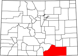
Location of Abeyta, Colorado.
USA Colorado location map.svg
Red pog.svg
Abeyta
Abeyta (Colorado)
Coordinates: 37°04′47″N104°11′11″W / 37.0797°N 104.1864°W / 37.0797; -104.1864 [1]
Country United States
State Colorado
County Las Animas [2]
Government
  Body Las Animas County [2]
Elevation
[1]
5,725 ft (1,745 m)
GNIS pop ID 194941

Abeyta is an extinct town in Las Animas County, in the U.S. state of Colorado.

Contents

History

Originally known as San Isidro, the Abeyta post office operated for a few days in December 1914. [3] [4] The community was named after Mrs. Abeyta, the mother of one Casimiro Barela. [5]

Geography

The Abeyta townsite is located at 37°04′47″N104°11′11″W / 37.0797°N 104.1864°W / 37.0797; -104.1864 (Abeyta) at an elevation of 5,725 feet (1,745 m). [6]

See also

References

  1. 1 2 "Abeyta, Colorado". Geographic Names Information System . United States Geological Survey, United States Department of the Interior . Retrieved December 29, 2024.
  2. 1 2 "Colorado Counties". Colorado Department of Local Affairs . Retrieved December 29, 2024.
  3. Bauer, William H.; Ozment, James L.; Willard, John H. (1990). Colorado Post Offices 1859–1989. Golden, Colorado: Colorado Railroad Historical Foundation. ISBN   0-918654-42-4.
  4. Donald R. Elliott (1999). Doris L. Elliott (ed.). Place Names of Colorado (PDF). Colorado Council of Genealogical Societies. p. 2. Archived (PDF) from the original on 2019-03-28. Retrieved 1 July 2019 via Denver Public Library.
  5. Dawson, John Frank (1954). Place names in Colorado: why 700 communities were so named, 150 of Spanish or Indian origin. Denver, CO: The J. Frank Dawson Publishing Co. p. 5.
  6. U.S. Geological Survey Geographic Names Information System: Abeyta, Colorado