Boncarbo, Colorado

Last updated
Boncarbo, Colorado
Boncarbo, Colorado.JPG
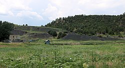
An old house and a slag heap in Boncarbo
Usa edcp location map.svg
Red pog.svg
Boncarbo
Location of Boncarbo, Colorado.
USA Colorado location map.svg
Red pog.svg
Boncarbo
Boncarbo (Colorado)
Coordinates: 37°13′00″N104°41′42″W / 37.2167°N 104.6950°W / 37.2167; -104.6950 [1]
Country United States of America
State State of Colorado
County Las Animas County [2]
Established1915 [3]
Government
  Type unincorporated community
  Body Las Animas County [2]
Elevation
[1]
6,877 ft (2,096 m)
Time zone UTC−07:00 (MST)
  Summer (DST) UTC−06:00 (MDT)
ZIP Code
81024 [4]
GNIS pop ID 194660

Boncarbo is an unincorporated community in Las Animas County, Colorado, United States. The ZIP Code of Boncarbo is 81024. [4]

Contents

History

The town of Boncarbo was established by the American Smelting and Refining Company in 1915. [3] Boncarbo is a corruption of the French bon carbon, meaning good coal. [3] The Boncarbo, Colorado, post office operated from November 15, 1917, until August 12, 2017. [5] Most of the coal mined at Boncarbo was sent to Cokedale for coking. [3]

Geography

Boncarbo is located at coordinates 37°13′00″N104°41′42″W / 37.2167°N 104.6950°W / 37.2167; -104.6950 at an elevation of 6,877 feet (2,096 m).

See also

Related Research Articles

<span class="mw-page-title-main">Aguilar, Colorado</span> Statutory Town in Colorado, United States

Aguilar is a Statutory Town located in Las Animas County, Colorado, United States. The town population was 456 at the 2020 United States Census. Cattleman and prominent pioneer José Ramón Aguilar founded the town in 1894.

<span class="mw-page-title-main">Bond, Colorado</span> An unincorporated community in Eagle County, Colorado, United States.

Bond is an unincorporated community and U.S. Post Office located along the Colorado River in Eagle County, Colorado, United States. The Bond post office has the ZIP Code 80423. Although Bond has never had a sizable population, the town has significant railroad history, and once was a stop for most of the passenger trains along the Denver and Rio Grande Western's main line.

<span class="mw-page-title-main">Anton, Colorado</span> An unincorporated community in Washington County, Colorado, United States

Anton is an unincorporated community and U.S. Post Office in Washington County, Colorado, United States.

Austin is a neighborhood within the boundaries of the incorporated Town of Orchard City in Delta County, Colorado, United States. There is a U.S. Post Office in Austin with the ZIP Code 81410.

<span class="mw-page-title-main">Briggsdale, Colorado</span> Census Designated Place in Colorado, United States

Briggsdale is an unincorporated town, a post office, and a census-designated place (CDP) located in and governed by Weld County, Colorado, United States. The CDP is a part of the Greeley, CO Metropolitan Statistical Area. The Briggsdale post office has the ZIP Code 80611. At the United States Census 2020, the population of the Briggsdale CDP was 134.

<span class="mw-page-title-main">Model, Colorado</span> Unincorporated community in Colorado, United States

Model is an abandoned unincorporated village in Las Animas County, Colorado, United States. The Model Post Office serving ZIP Code 81059 was in operation from 1912 to 2021, and was the last business or service standing there for many years. The community originally was a planned, or "model" community, hence the name.

<span class="mw-page-title-main">Trinchera, Colorado</span> Unincorporated community in Colorado, United States

Trinchera is an unincorporated community and a U.S. Post Office located in Las Animas County, Colorado, United States. The Trinchera Post Office has the ZIP Code 81081.

<span class="mw-page-title-main">Delhi, Colorado</span> Unincorporated community in State of Colorado, United States

Delhi is an unincorporated community in Las Animas County, Colorado, United States. The U.S. Post Office at Model now serves Delhi postal addresses.

Sopris was an unincorporated community located in Las Animas County, Colorado, United States. The town is now under the surface of Trinidad Lake in Trinidad Lake State Park.

<span class="mw-page-title-main">Thatcher, Colorado</span> Unincorporated community in Colorado, United States

Thatcher is an unincorporated community located in Las Animas County, Colorado, United States. The U.S. Post Office at Model now serves Thatcher postal addresses.

<span class="mw-page-title-main">Tyrone, Colorado</span> Unincorporated community in Colorado, United States

Tyrone is an unincorporated community located in Las Animas County, Colorado, United States. The U.S. Post Office at Model now serves Tyrone postal addresses.

Willard is an unincorporated community located in Logan County, Colorado, United States.

<span class="mw-page-title-main">Altona, Colorado</span> A census-designated place in Boulder County, Colorado, United States

Altona is an unincorporated community and a census-designated place (CDP) located in and governed by Boulder County, Colorado, United States. The CDP is a part of the Boulder, CO Metropolitan Statistical Area. The population of the Altona CDP was 512 at the United States Census 2020. The Boulder post office serves the area.

<span class="mw-page-title-main">Boggsville, Colorado</span> A ghost town in Bent County, Colorado, United States.

Boggsville is an extinct town located in Bent County, Colorado, United States. The town was located near the Purgatoire River about 3 miles (4.8 km) above the Purgatoire's confluence with the Arkansas River. It lies along Highway 101 about 2 miles south of Las Animas.

<span class="mw-page-title-main">National Register of Historic Places listings in Las Animas County, Colorado</span>

This is a list of the National Register of Historic Places listings in Las Animas County, Colorado.

<span class="mw-page-title-main">Brodhead, Colorado</span> Ghost town

Brodhead is an extinct coal mining town located in Las Animas County, Colorado, United States. The townsite is located at 37.4108°N 104.6764°W at an elevation of 6,919 feet (2,109 m).

Barela is an unincorporated community located in Las Animas County, Colorado, United States.

Abeyta is an extinct town in Las Animas County, in the U.S. state of Colorado.

Adena is an extinct town located in Morgan County, Colorado, United States.

Beshoar is an extinct town located in Las Animas County, Colorado, United States. The townsite is located at coordinates 39.0000°N 102.0000°W at an elevation of 5,922 feet (1,805 m).

References

  1. 1 2 "Boncarbo, Colorado". Geographic Names Information System . United States Geological Survey, United States Department of the Interior . Retrieved January 28, 2025.
  2. 1 2 "Colorado Counties". Colorado Department of Local Affairs . Retrieved January 28, 2025.
  3. 1 2 3 4 Eichler, Geo. R. (1977). Colorado Place Names. Boulder, Colo.: Johnson Publishing Company. LCCN   77-89726.
  4. 1 2 "ZIP Code Lookup". United States Postal Service. Archived from the original (JavaScript/HTML) on September 3, 2007. Retrieved September 4, 2007.
  5. Bauer, William H.; Ozment, James L.; Willard, John H. (1990). Colorado Post Offices 1859–1989. Golden, Colorado: Colorado Railroad Historical Foundation. ISBN   0-918654-42-4.

}