Devine, Colorado

Last updated
Devine, Colorado
Colorado State Highway 231.JPG
Looking south along Colorado State Highway 231 in Devine.
Usa edcp location map.svg
Red pog.svg
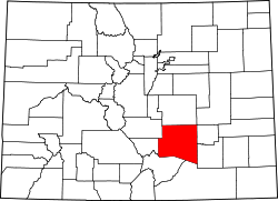
Devine
Location of the Devine, Colorado.
USA Colorado location map.svg
Red pog.svg
Devine
Devine (Colorado)
Coordinates: 38°16′30″N104°27′27″W / 38.2750°N 104.4575°W / 38.2750; -104.4575 (Devine, Colorado) [1]
Country United States
State Colorado
County Pueblo [2]
Government
  Type unincorporated community
  Body Pueblo County [2]
Elevation
[1]
4,584 ft (1,397 m)
Time zone UTC−07:00 (MST)
  Summer (DST) UTC−06:00 (MDT)
ZIP code [3]
Pueblo 81001
Area code 719
GNIS place ID 204799

Devine is an unincorporated community located in and governed by Pueblo County, Colorado, United States. [1]

Contents

History

The unincorporated community has never had its own post office. [4] The Pueblo, Colorado, post office (ZIP code 81001) serves the area. [3]

The community was named after Thomas Devine, a railroad official. [5]

Geography

Devine is located in Pueblo County at coordinates 38°16′30″N104°27′27″W / 38.2750°N 104.4575°W / 38.2750; -104.4575 (Devine, Colorado) and elevation 4,584 feet (1,397 m). [1]

See also

References

  1. 1 2 3 4 "Devine, Colorado". Geographic Names Information System . United States Geological Survey, United States Department of the Interior . Retrieved October 4, 2025.
  2. 1 2 "Colorado Counties". Colorado Department of Local Affairs . Retrieved October 4, 2025.
  3. 1 2 "ZIP Code Lookup". United States Postal Service . Retrieved October 4, 2025.
  4. Bauer, William H.; Ozment, James L.; Willard, John H. (1990). Colorado Post Offices 1859–1989. Golden, Colorado: Colorado Railroad Historical Foundation. ISBN   0-918654-42-4.
  5. Dawson, John Frank. Place names in Colorado: why 700 communities were so named, 150 of Spanish or Indian origin. Denver, CO: The J. Frank Dawson Publishing Co. p. 18.