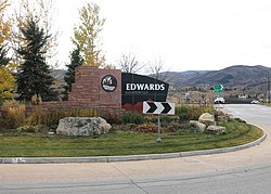
Edwards, Colorado | |
---|---|
Location of the Edwards CDP in the United States. | |
Coordinates: 39°37′17″N106°37′06″W / 39.62139°N 106.61833°W | |
Country | United States |
State | Colorado |
County | Eagle County |
Government | |
• Type | unincorporated town |
Area | |
• Total | 26.789 sq mi (69.382 km2) |
• Land | 26.636 sq mi (68.988 km2) |
• Water | 0.152 sq mi (0.394 km2) |
Elevation | 7,569 ft (2,307 m) |
Population | |
• Total | 11,246 |
• Density | 420/sq mi (160/km2) |
Time zone | UTC-7 (MST) |
• Summer (DST) | UTC-6 (MDT) |
ZIP Code [4] | 81632 |
Area code | 970 |
GNIS feature | 2408049 [1] |
Edwards is an unincorporated town, a post office, and a census-designated place (CDP) located in and governed by Eagle County, Colorado, United States. Edwards is the principal town of the Edwards, CO Micropolitan Statistical Area. The Edwards post office has the ZIP Code 81632. [4] At the United States Census 2020, the population of the Edwards CDP was 11,246. [3] The Edwards Metropolitan District provides services.
The Edwards Post Office has been in operation since 1883. [5] The community was named after Melvin Edwards, a local postal official. [6]
Edwards is in the valley of the Eagle River and extends southwards up the valleys of Lake Creek and Colorow Creek, at the north end of the Sawatch Range. It is bordered to the east by the town of Avon. U.S. Route 6 runs through the center of Edwards on the south side of the Eagle River, while Interstate 70 runs through the CDP north of the river, with access from Exit 163. Via I-70, it is 14 miles (23 km) east to Vail, 110 miles (180 km) east to Denver, 17 miles (27 km) west to Eagle, and 47 miles (76 km) west to Glenwood Springs.
The Edwards CDP has an area of 17,145 acres (69.382 km2), including 97 acres (0.394 km2) of water. [2]
Edwards is served by Eagle County School District Re-50J. The community is home to an elementary school, a middle school, three high schools, and a charter school:
Colorado Mountain College operates its Vail Valley campus in Edwards. [7]
The United States Census Bureau initially defined the Edwards CDP for the United States Census 2000.
Year | Pop. | ±% |
---|---|---|
2000 | 8,257 | — |
2010 | 10,266 | +24.3% |
2020 | 11,246 | +9.5% |
Source: United States Census Bureau |
Edwards is in a favorable location for skiers and riders. Beaver Creek Resort is 4 miles (6 km) to the east while Vail is 14.5 miles (23.3 km) to the east.
Eagle County is a county located in the U.S. state of Colorado. As of the 2020 census, the population was 55,731. The county seat is the Town of Eagle and the most populous community is Edwards. The county is named for the Eagle River.
Avon is a Home Rule Town located in Eagle County, Colorado, United States. The town population was 6,072 at the 2020 United States Census. The town is a part of the Edwards, CO Micropolitan Statistical Area. Avon is the gateway to the Beaver Creek Resort which lies about two miles (3 km) south of the town. It was the previous site of Vail Resorts before the company moved its physical headquarters to Broomfield, Colorado, in 2006. The town is the home of Liberty Skis, an independent ski manufacturing company.
Eagle is the home rule municipality that is the county seat of Eagle County, Colorado, United States. The town population was 7,511 at the 2020 United States census, a +15.41% increase since the 2010 census. Eagle is the part of the Edwards, CO Micropolitan Statistical Area.
El Jebel is an unincorporated community and a census-designated place (CDP) located in and governed by Eagle County, Colorado, United States. The CDP is a part of the Edwards, CO Micropolitan Statistical Area. The population of the El Jebel CDP was 4,130 at the United States Census 2020. The Carbondale Post Office serves El Jebel postal addresses.
The Town of Gypsum is the home rule municipality that is the most populous municipality in Eagle County, Colorado, United States. The town population was 8,040 at the 2020 United States Census, a +24.13% increase since the 2010 United States Census. Gypsum is a part of the Edwards, CO Micropolitan Statistical Area. Gypsum is the home of an American Gypsum drywall plant and mine.
Evergreen is an unincorporated town, a post office, and a census-designated place (CDP) located in and governed by Jefferson County, Colorado, U.S. The CDP is a part of the Denver–Aurora–Lakewood, CO Metropolitan Statistical Area. The Evergreen post office has the ZIP Codes 80439 and 80437. At the 2020 census, the population of the Evergreen CDP was 9,307. The Evergreen Metropolitan District provides services.
Kittredge is an unincorporated town, a post office, and a census-designated place (CDP) located in and governed by Jefferson County, Colorado, United States. The CDP is a part of the Denver–Aurora–Lakewood, CO Metropolitan Statistical Area. The Kittredge post office has the ZIP code 80457. At the United States Census 2020, the population of the Kittredge CDP was 1,308.
Atwood is an unincorporated town, a post office, and a census-designated place (CDP) located in Logan County, Colorado, United States. The CDP is a part of the Sterling, CO Micropolitan Statistical Area. At the United States Census 2020, the population of the Atwood CDP was 138.
Padroni is an unincorporated town, a census-designated place (CDP), and a post office located in and governed by Logan County, Colorado, United States. The CDP is a part of the Sterling, CO Micropolitan Statistical Area. The Padroni post office has the ZIP Code 80745. At the United States Census 2020, the population of the Padroni CDP was 75.
Clifton is a census-designated place (CDP) and post office in and governed by Mesa County, Colorado, United States. It is part of the Grand Junction, CO Metropolitan Statistical Area. The Clifton post office has the ZIP Code 81520. As of the 2020 census, the population of the Clifton CDP was 20,413.
Rollinsville is a census-designated place (CDP) and post office in and governed by Gilpin County, Colorado, United States. The CDP is a part of the Denver–Aurora–Lakewood, CO Metropolitan Statistical Area. The Rollinsville post office has the ZIP Code 80474. At the United States Census 2020, the population of the Rollinsville CDP was 194.
Heeney is an unincorporated community and a census-designated place (CDP) located in and governed by Summit County, Colorado, United States. The CDP is a part of the Breckenridge, CO Micropolitan Statistical Area. The population of the Heeney CDP was 74 at the United States Census 2020. The Silverthorne post office (Zip Code 80498) serves Heeney postal addresses.
Elbert is an unincorporated town, a post office, and a census-designated place (CDP) located in and governed by Elbert County, Colorado, United States. The CDP is a part of the Denver–Aurora–Lakewood, CO Metropolitan Statistical Area. The Elbert post office has the ZIP Code 80106. At the United States Census 2020, the population of the Elbert CDP was 188.
Coaldale is a census-designated place (CDP) and post office located in and governed by Fremont County, Colorado, United States. The CDP is a part of the Cañon City, CO Micropolitan Statistical Area. The Coaldale post office has the ZIP Code 81222. At the United States Census 2020, the population of the Coaldale CDP was 343.
Howard is a census-designated place (CDP) and post office in and governed by Fremont County, Colorado, United States. The CDP is a part of the Cañon City, CO Micropolitan Statistical Area. The Howard post office has the ZIP Code 81233. At the United States Census 2020, the population of the Howard CDP was 852.
McCoy is an unincorporated town, a census-designated place (CDP), and a post office located in and governed by Eagle County, Colorado, United States. The CDP is a part of the Edwards, CO Micropolitan Statistical Area. The McCoy post office has the ZIP Code 80463. At the United States Census 2020, the population of the McCoy CDP was 30.
Orchard is an unincorporated town, a post office, and a census-designated place (CDP) located in and governed by Morgan County, Colorado, United States. The CDP is a part of the Fort Morgan, CO Micropolitan Statistical Area. The Orchard post office has the ZIP Code 80649. As of the 2020 census, the population of the Orchard CDP was 76.
Snyder is an unincorporated town, a post office, and a census-designated place (CDP) located in and governed by Morgan County, Colorado, United States. The CDP is a part of the Fort Morgan, CO Micropolitan Statistical Area. The Snyder post office has the ZIP Code 80750. As of the 2020 census, the population of the Snyder CDP was 136.
Weldona is an unincorporated town, a post office, and a census-designated place (CDP) located in and governed by Morgan County, Colorado, United States. The CDP is a part of the Fort Morgan, CO Micropolitan Statistical Area. The Weldona post office has the ZIP Code 80653. At the United States Census 2020, the population of the Weldona CDP was 113.
Wolcott is an unincorporated town, a post office, and a census-designated place (CDP) located in and governed by Eagle County, Colorado, United States. The CDP is a part of the Edwards, CO Micropolitan Statistical Area. The Wolcott post office has the ZIP Code 81655. At the United States Census 2020, the population of the Wolcott CDP was 20.