Kent County, Maryland

Last updated

Kent County
KentCountyCourthouseMD 2015.jpg
Kent County Courthouse in Chestertown
Flag of Kent County, Maryland.gif
Seal of Kent County, Maryland.gif
Map of Maryland highlighting Kent County.svg
Location within the U.S. state of Maryland
Maryland in United States.svg
Maryland's location within the U.S.
Coordinates: 39°14′N76°06′W / 39.23°N 76.1°W / 39.23; -76.1
CountryFlag of the United States.svg United States
StateFlag of Maryland.svg  Maryland
FoundedDecember 30, 1642
Named for Kent
Seat Chestertown
Largest townChestertown
Area
  Total413 sq mi (1,070 km2)
  Land277 sq mi (720 km2)
  Water136 sq mi (350 km2)  33%
Population
 (2020)
  Total19,198
  Density46/sq mi (18/km2)
Time zone UTC−5 (Eastern)
  Summer (DST) UTC−4 (EDT)
Congressional district 1st
Website www.kentcounty.com

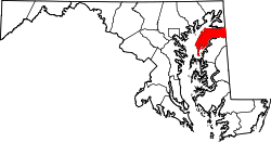
Kent County is a county located in the U.S. state of Maryland. As of the 2020 census, its population was 19,198, [1] making it the least populous county in Maryland. Its county seat is Chestertown. [2] The county was named for the county of Kent in England. [3]

Contents

The county is located on the Eastern Shore of Maryland. Along with Caroline and Garrett Counties, it is one of three counties in the state that are not part of a metropolitan statistical area.

History

In 1608, Captain John Smith explored and mapped a portion of what is now Kent County. In 1642, the governor and council appointed commissioners for the Isle and County of Kent. This act appears to have led to the establishment of Kent County. In 1675, the first county seat was New Yarmouth. The seat was briefly moved upriver to Quaker Neck, and then to the site of modern Chestertown. Before the American Revolution, New Town on Chester, now Chestertown, was a port entry for the counties of Cecil, Kent, and Queen Anne's. [4]

The county has a number of properties which are listed on the National Register of Historic Places. [5]

Kent County was the mean center of U.S. population in the 1790 census.

In 1793, the county had its first newspaper, called Apollo, or Chestertown Spy. It was succeeded by local papers such as the Chestertown Gazette.

Washington College, the oldest college in Maryland, is located in Kent County. It was the first college charted in the nation after the Declaration of Independence and was founded by William Smith in 1782. George Washington authorized the use of his name and gave the college its largest gift of 50 guineas. Washington served on the Board of Visitors and Governors for five years. The college has been host to four United States Presidents, including George Washington, Harry S. Truman, Dwight D. Eisenhower, and Franklin D. Roosevelt. All were awarded honorary degrees from the college.

War of 1812

The War of 1812 was the only war Kent County experienced on its soil. During the spring and summer of both 1813 and 1814, residents faced immediate threats from the enemy as the British terrorized the Chesapeake, looting and burning farms and towns. Kent County citizens and local militia were tested and stood their ground with ingenuity and determination during the burning of Georgetown, the rescue of the Kitty Knight House and the Battle of Caulk's Field. [6]

Historical churches

St. Paul's, the oldest Episcopal Church in Maryland used continuously as a place of worship. The earliest part of the building was constructed in 1711. [7] It is located approximately nine miles west of Chestertown.

Christ Church, frequently called I.U., was founded in 1765. Colonel Philip Reed a Continental Army and War of 1812 soldier is buried here.

Shrewsbury Church is believed to be the first structure erected in the county, in 1693. John Cadwalader is buried in the Shrewsbury churchyard. The eulogy on his tomb was written by Thomas Paine. [8]

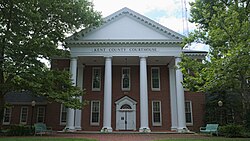
Politics and government

Kent County was granted home rule in 1970 under a state code.

In the early post-Civil War era, Kent County was heavily Confederate-leaning and leaned towards the Democratic Party. [9] William McKinley was the only Republican to carry the county between 1876 and 1924. After that, although carried by Franklin Roosevelt and Harry Truman during the five consecutive Democratic victories between 1932 and 1948, the county trended Republican relative to national voting. Currently, along with Talbot County further south, Kent County is the most politically competitive county on the Eastern Shore of Maryland. In 2004, Republican George W. Bush won it with 52.8% of the vote to Democrat John Kerry's 46.1%. In the 2008 United States Presidential Election, Barack Obama won Kent County by 48 votes more than John McCain. [10] In 2012, Republican Mitt Romney won Kent County by 28 votes over Democrat Barack Obama. In 2016, Republican Donald Trump won Kent County with 48.7% of the vote to Democrat Hillary Clinton's 45.7%, and a 20-year record high of 5.7% of the vote for third-party candidates. In 2020, Joe Biden flipped the county, winning it by 134 votes. [11]

The members of the County Council as of 2022 are: [12]

Kent County Commissioners [13]
PositionNameAffiliationDistrictFirst Elected
 PresidentRonald H. Fithian Republican At Large2006
 MemberAlbert H. Nickerson Republican At Large2022
 MemberJohn F. Price Republican At Large2022

Kent County lies wholly in Senate District 36 and elects three House of Delegates Members who serve at-large countywide. Members listed below as of 2018 are:

State Senators and Delegates [14]
PositionDistrictNameAffiliationFirst Elected
  Senate 36 Stephen Hershey Jr. [15] Republican 2012
  House of Delegates 36A Steven Arentz [16] Republican 2013
  House of Delegates 36B Jefferson Ghrist [17] Republican 2014
  House of Delegates 36C Jay A. Jacobs [18] Republican 2010

Voter registration

Voter registration and party enrollment as of March 2024 [19]
Democratic 5,770
Republican 5,297
Unaffiliated2,778
Libertarian 69
Other parties 143
Total14,057
United States presidential election results for Kent County, Maryland [20]
Year Republican Democratic Third party
No.%No.%No.%
2020 5,19548.13%5,32949.37%2702.50%
2016 4,87648.66%4,57545.65%5705.69%
2012 4,87049.17%4,84248.89%1921.94%
2008 4,90548.95%4,95349.43%1621.62%
2004 4,90052.77%4,27846.07%1071.15%
2000 4,15551.39%3,62744.86%3033.75%
1996 3,05543.66%3,20745.83%73610.52%
1992 3,09440.56%3,09340.55%1,44118.89%
1988 3,76155.87%2,92543.45%460.68%
1984 3,89761.63%2,39037.80%360.57%
1980 2,88945.83%2,98647.37%4296.81%
1976 2,82146.77%3,21153.23%00.00%
1972 4,03664.36%2,16834.57%671.07%
1968 2,94646.50%2,24335.41%1,14618.09%
1964 2,00832.81%4,11367.19%00.00%
1960 3,26451.46%3,07948.54%00.00%
1956 3,74761.18%2,37838.82%00.00%
1952 3,65659.24%2,50440.58%110.18%
1948 2,48949.31%2,52450.00%350.69%
1944 2,35148.93%2,45451.07%00.00%
1940 2,63946.45%3,01453.05%280.49%
1936 2,54346.18%2,93153.22%330.60%
1932 1,46838.09%2,37061.49%160.42%
1928 2,77752.82%2,45046.60%300.57%
1924 2,01942.51%2,62855.34%1022.15%
1920 2,83848.22%3,03451.55%140.24%
1916 1,67346.38%1,88652.29%481.33%
1912 1,02130.21%1,81653.73%54316.07%
1908 1,75346.98%1,93951.97%391.05%
1904 1,84147.91%1,95650.90%461.20%
1900 2,42653.05%2,07645.40%711.55%
1896 2,39953.73%1,98044.34%861.93%
1892 1,88647.27%2,00950.35%952.38%
1888 2,03748.64%2,06249.24%892.13%
1884 2,04848.22%2,15250.67%471.11%
1880 1,85348.48%1,96951.52%00.00%
1876 1,68546.52%1,93753.48%00.00%
1872 1,65850.53%1,62349.47%00.00%
1868 26616.65%1,33283.35%00.00%
1864 41324.55%1,26975.45%00.00%
1860 422.53%744.45%1,54693.02%
1852 66254.58%55145.42%00.00%
1848 64558.90%44740.82%30.27%
1844 72858.01%52741.99%00.00%
1840 67958.79%47641.21%00.00%
1836 58961.61%36738.39%00.00%

Law enforcement

The head of the Kent County Sheriff's Office is Dennis Hickman.

Geography

According to the U.S. Census Bureau, the county has a total area of 413 square miles (1,070 km2), of which 277 square miles (720 km2) is land and 136 square miles (350 km2) (33%) is water. [21]

According to the Maryland Geological Survey, the highest point in Kent County is 102 ft above sea level, approximately 2.25 mi west of Coleman's Corner (shown on maps as "Coleman"), just northeast of the mouth of Still Pond Creek. [22]

Kent County has a 209-mile shoreline, including Eastern Neck Island. The Chesapeake Bay is on the west, Sassafras River on the north, and the Chester River on the south. The eastern border with Delaware is part of the Mason–Dixon line.

Nearby cities: Baltimore, MD; Washington D.C.; Philadelphia, PA; Wilmington, DE

Adjacent counties

National protected area

Major roads and highways

Demographics

Historical population
CensusPop.Note
1790 12,836
1800 11,771−8.3%
1810 11,450−2.7%
1820 11,4530.0%
1830 10,501−8.3%
1840 10,8423.2%
1850 11,3865.0%
1860 13,26716.5%
1870 17,10228.9%
1880 17,6052.9%
1890 17,471−0.8%
1900 18,7867.5%
1910 16,957−9.7%
1920 15,026−11.4%
1930 14,242−5.2%
1940 13,465−5.5%
1950 13,6771.6%
1960 15,48113.2%
1970 16,1464.3%
1980 16,6953.4%
1990 17,8426.9%
2000 19,1977.6%
2010 20,1975.2%
2020 19,198−4.9%
2023 (est.)19,303 [23] 0.5%
U.S. Decennial Census [24]
1790–1960 [25] 1900–1990 [26]
1990–2000 [27] 2010–2018 [28]

2010 census

A farm in Kent County, Maryland KentCountyMD.jpg
A farm in Kent County, Maryland

As of the 2010 U.S. census, there were 20,197 people, 8,165 households, and 5,272 families living in the county. [29] The population density was 72.9 inhabitants per square mile (28.1/km2). There were 10,549 housing units at an average density of 38.1 per square mile (14.7/km2). [30] The racial makeup of the county was 80.1% white, 15.1% black or African American, 0.8% Asian, 0.2% American Indian, 1.9% from other races, and 1.8% from two or more races. Those of Hispanic or Latino origin made up 4.5% of the population. [29] In terms of ancestry, 18.7% were English, 18.7% were German, 15.5% were Irish, 7.9% were American, and 5.8% were Italian. [31]

Of the 8,165 households, 24.4% had children under the age of 18 living with them, 49.2% were married couples living together, 10.9% had a female householder with no husband present, 35.4% were non-families, and 29.6% of all households were made up of individuals. The average household size was 2.29 and the average family size was 2.78. The median age was 45.6 years. [29]

The median income for a household in the county was $50,141 and the median income for a family was $63,507. Males had a median income of $41,046 versus $35,161 for females. The per capita income for the county was $29,536. About 5.1% of families and 12.2% of the population were below the poverty line, including 14.9% of those under age 18 and 7.8% of those age 65 or over. [32]

Education

Kent County Public Schools is the school district for all of Kent County. [33]

Communities

This county contains the following incorporated municipalities:

Towns

Census-designated places

The United States Census Bureau recognizes the following Census-designated places in Kent County:

Unincorporated communities

Other unincorporated places not listed as Census-Designated Places but known in the area include:

Notable people

Miscellaneous

See also

Related Research Articles

<span class="mw-page-title-main">Frederick County, Maryland</span> County in Maryland, United States

Frederick County is located in Maryland, United States. As of the 2020 U.S. census, the population was 271,717. The county seat is Frederick.

<span class="mw-page-title-main">Cecil County, Maryland</span> County in the United States

Cecil County is a county located in the U.S. state of Maryland at the northeastern corner of the state, bordering both Pennsylvania and Delaware. As of the 2020 census, the population was 103,725. The county seat is Elkton.

<span class="mw-page-title-main">Harford County, Maryland</span> County in Maryland, United States

Harford County is located in the U.S. state of Maryland. As of the 2020 census, the population was 260,924. Its county seat is Bel Air. Harford County is included in the Baltimore-Columbia-Towson, MD Metropolitan Statistical Area, which is also included in the Washington-Baltimore-Arlington, DC-MD-VA-WV-PA Combined Statistical Area.

<span class="mw-page-title-main">Caroline County, Maryland</span> County in Maryland, United States

Caroline County is a rural county located in the U.S. state of Maryland on its Eastern Shore. As of the 2020 census, the population was 33,293. Its county seat is Denton.

<span class="mw-page-title-main">Dorchester County, Maryland</span> County in Maryland, United States

Dorchester County is a county located in the U.S. state of Maryland. At the 2020 census, the population was 32,531. Its county seat is Cambridge. The county was formed in 1669 and named for the Earl of Dorset, a family friend of the Calverts.

<span class="mw-page-title-main">Queen Anne's County, Maryland</span> County in Maryland, United States

Queen Anne's County is located on the Eastern Shore of the U.S. state of Maryland. As of the 2020 census, the population was 49,874. Its county seat and most populous municipality is Centreville. The census-designated place of Stevensville is the county's most populous place with population of 7,442 as of 2020. The county is named for Queen Anne of Great Britain, who reigned when the county was established in 1706 during the colonial period.

<span class="mw-page-title-main">Wicomico County, Maryland</span> County in Maryland, United States

Wicomico County is located in the southeastern part of the U.S. state of Maryland, on the Delmarva Peninsula. As of the 2020 census, the population was 103,588. The county seat is Salisbury. The county was named for the Wicomico River, which in turn derives its name from the Algonquian language words wicko mekee, meaning "a place where houses are built," apparently referring to a Native American town on the banks. The county is included in the Salisbury, MD-DE Metropolitan Statistical Area.

<span class="mw-page-title-main">Worcester County, Maryland</span> County in Maryland, United States

Worcester County is the easternmost county of the U.S. state of Maryland. As of the 2020 census, the population was 52,460. Its county seat is Snow Hill.

<span class="mw-page-title-main">Cambridge, Maryland</span> City in Maryland, United States

Cambridge is a city in Dorchester County, Maryland, United States. The population was 13,096 at the 2020 census. It is the county seat of Dorchester County and the county's largest municipality. Cambridge is the fourth most populous city in Maryland's Eastern Shore region, after Salisbury, Elkton and Easton.

<span class="mw-page-title-main">Betterton, Maryland</span> Historic district in Maryland, United States

Betterton is a town in Kent County, Maryland, United States. The population was 345 at the 2010 census.

<span class="mw-page-title-main">Chestertown, Maryland</span> Town in Maryland, United States

Chestertown is a town in Kent County, Maryland, United States. The population was 5,252 as of the 2010 census. It is the county seat of Kent County.

<span class="mw-page-title-main">Galena, Maryland</span> Town in Maryland, United States

Galena is a town in Kent County, Maryland, United States. The population was 612 at the 2010 census.

<span class="mw-page-title-main">Rock Hall, Maryland</span> Town in Maryland, United States

Rock Hall, is a waterfront town located directly on the National Chesapeake Scenic Byway in Kent County, Maryland, United States. The population was 1,310 at the 2010 census.

<span class="mw-page-title-main">Eastern Shore of Maryland</span> Part of the U.S. state of Maryland

The Eastern Shore of Maryland is a part of the U.S. state of Maryland that lies mostly on the east side of the Chesapeake Bay. Nine counties are normally included in the region. The Eastern Shore is part of the larger Delmarva Peninsula that Maryland shares with Delaware and Virginia.

<span class="mw-page-title-main">Maryland Route 21</span> State highway in Kent County, Maryland, US, known as Tolchester Beach Rd

Maryland Route 21 is a state highway in the U.S. state of Maryland. Known as Tolchester Beach Road, the highway runs 2.42 miles (3.89 km) from MD 445 near Tolchester Beach east to MD 20 near Fairlee in western Kent County. MD 21 was constructed in the mid-1920s to provide a modern road connection to Tolchester Beach, then a major beach resort on the Chesapeake Bay. The highway's western terminus was rolled back to MD 445 in the early 1990s.

Still Pond is a census-designated place in Kent County, Maryland, United States. Still Pond is located at the intersection of Maryland routes 292 and 566 on Still Pond Neck, south-southeast of Betterton and north of Chestertown. Much of the community is included in the Still Pond Historic District and it is notable as the first place in Maryland in which women gained the right to vote.

Worton is an unincorporated community and census-designated place (CDP) in Kent County, Maryland, United States. As of the 2010 census it had a population of 249.

<span class="mw-page-title-main">Kennedyville, Maryland</span> Census-designated place in Maryland, United States

Kennedyville is an unincorporated community and census-designated place in Kent County, Maryland, United States. As of the 2010 census it had a population of 199.

Butlertown is an unincorporated community and census-designated place in Kent County, Maryland, United States. Per the 2020 census, the population was 520.

Georgetown is an unincorporated community and census-designated place in western Kent County, Maryland, United States. Per the 2020 census, the population was 117. It should not be confused with the community of the same name 22 miles (35 km) to the northeast on the Kent/Cecil County border.

References

  1. "QuickFacts: Kent County, Maryland". U.S. Census Bureau . Retrieved March 26, 2022.
  2. "Find a County". National Association of Counties. Archived from the original on May 31, 2011. Retrieved June 7, 2011.
  3. Gannett, Henry (1905). The Origin of Certain Place Names in the United States. Govt. Print. Off. pp.  173.
  4. Clark, Charles; Robert Swain, Jr. (1950). The Eastern Shore of Maryland and Virginia. New York: Lewis Historical Publishing Company. pp. 917–938.
  5. "National Register Information System". National Register of Historic Places . National Park Service. April 15, 2008.
  6. "The Key to Kent County History". Kent County Historical Society. Retrieved August 20, 2020.
  7. McCall, Davy (1993). A Tricentennial History of St. Paul's Church, Kent. Published in Chestertown, Maryland.{{cite book}}: CS1 maint: location missing publisher (link)
  8. DeProspo, DeProspo (1998). A History of Shrewsbury Parish Church. Chestertown, MD: Chesapeake College Press.
  9. Levine, Mark V.; 'Standing Political Decisions and Critical Realignment: The Pattern of Maryland Politics, 1872-1948'; The Journal of Politics , volume 38, no. 2 (May 1976), pp. 292-325
  10. "CNN Maryland Results 2008 election". Cable News Network.
  11. "Official 2016 Presidential General Election results for Kent County". elections.maryland.gov. December 9, 2016. Retrieved July 15, 2020.
  12. "County Commissioners". kentcounty.com. Kent County, Maryland. Retrieved December 7, 2022.
  13. "Commissioners of Kent County Maryland". www.kentcounty.com. Retrieved March 14, 2024.
  14. "Maryland General Assembly - Kent County Members". msa.maryland.gov. Retrieved June 3, 2021.
  15. "Stephen S. Hershey, Jr., Maryland State Senator". msa.maryland.gov. Retrieved June 3, 2021.
  16. "Steven J. Arentz, Maryland State Delegate". msa.maryland.gov. Retrieved June 3, 2021.
  17. "Jefferson L. Ghrist, Maryland State Delegate". msa.maryland.gov. Retrieved June 3, 2021.
  18. "Jay A. Jacobs, Maryland State Delegate". msa.maryland.gov. Retrieved June 3, 2021.
  19. "Maryland Board of Elections Voter Registration Activity Report March 2024" (PDF). Maryland Board of Elections. Retrieved April 9, 2024.
  20. Leip, David. "Dave Leip's Atlas of U.S. Presidential Elections". uselectionatlas.org. Retrieved June 11, 2018.
  21. "2010 Census Gazetteer Files". United States Census Bureau. August 22, 2012. Archived from the original on September 13, 2014. Retrieved September 12, 2014.
  22. "Maryland Geological Survey". Maryland Department of Natural Resources. Archived from the original on October 5, 2007. Retrieved July 21, 2011.
  23. "Annual Estimates of the Resident Population for Counties: April 1, 2020 to July 1, 2023". United States Census Bureau. Retrieved April 3, 2024.
  24. "U.S. Decennial Census". United States Census Bureau. Retrieved September 12, 2014.
  25. "Historical Census Browser". University of Virginia Library. Retrieved September 12, 2014.
  26. "Population of Counties by Decennial Census: 1900 to 1990". United States Census Bureau. Retrieved September 12, 2014.
  27. "Census 2000 PHC-T-4. Ranking Tables for Counties: 1990 and 2000" (PDF). United States Census Bureau. Retrieved September 12, 2014.
  28. "State & County QuickFacts". United States Census Bureau. Archived from the original on June 6, 2011. Retrieved August 24, 2013.
  29. 1 2 3 "DP-1 Profile of General Population and Housing Characteristics: 2010 Demographic Profile Data". United States Census Bureau. Archived from the original on February 13, 2020. Retrieved January 22, 2016.
  30. "Population, Housing Units, Area, and Density: 2010 - County". United States Census Bureau. Archived from the original on February 13, 2020. Retrieved January 22, 2016.
  31. "DP02 Selected Social Characteristics in the United States – 2006-2010 American Community Survey 5-Year Estimates". United States Census Bureau. Archived from the original on February 13, 2020. Retrieved January 22, 2016.
  32. "DP03 Selected Economic Characteristics – 2006-2010 American Community Survey 5-Year Estimates". United States Census Bureau. Archived from the original on February 13, 2020. Retrieved January 22, 2016.
  33. "2020 census - school district reference map: Kent County, MD" (PDF). U.S. Census Bureau . Retrieved July 25, 2022. - Text list
  34. 1 2 "Report on School Desegregation in 14 Eastern shore and southern Maryland Counties" (PDF). February 1966. Retrieved June 3, 2020.

39°14′N76°06′W / 39.23°N 76.10°W / 39.23; -76.10