Madison County was organized by an act of the General Assembly of Georgia on December 11, 1811. It was named for James Madison,[3] who served as the fourth president of the United States from 1809 to 1817. It was the 38th county formed in Georgia, and began to function as a county in 1812. Madison County was formed from the counties of Clarke, Elbert, Franklin, Jackson, Oglethorpe.[4]
Early agriculture in Madison County was devoted to food crops and livestock (cattle, hogs, and sheep), which were sufficient to feed the population. Just after the Civil War ended, the demand for a cash crop led to major reliance on cotton.[5] The soils of Madison County were heavily damaged by this cotton monoculture. From the 1930s on, agriculture became more diverse. Today, agribusiness dominates the local economy, with poultry production particularly important.
Madison and Oglethorpe counties share Watson Mill Bridge State Park, the site of the longest covered bridge in Georgia. The bridge, which is over 100 years old, spans 229 feet of the South Fork of the Broad River. There are also facilities for camping, hiking trails, picnicking, and fishing in the park.
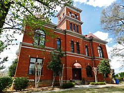
The Madison County Courthouse, one of the most ornate in Georgia, was built in 1901 for the sum of $18,314. It is listed on the National Register of Historic Places. New Hope Presbyterian Church, established in 1788, is the third oldest church in Georgia.[6]
In 1879, there were only four post offices in Madison County: Danielsville, Fort Lamar, Madison Springs and Paoli.[9] In 1889, Madison county had post offices at Carlton, Danielsville, Dowdy, Fort Lamar, Gholston (Gholston's Stand), Hix, Ila, Madison Springs, Medicus, Paoli and Planter.[10]
By 1900, additional post offices had been opened in Alvin, Berea, Boggs, Carruth, Comer, Fiveforks (now Comer), Jeptha, Larkin, Monitor, Neese, Pocataligo and Sorrells, while the offices in Gholston and Medicus had been closed.[11] By 1910, most of these post offices had closed; the only remaining ones were in Carlton, Colbert, Comer, Danielsville and Hull.[12]
By 1920, the office in Ila had reopened.[13] The county would retain these six post offices into the 21st century.[update][14]
Geography
According to the U.S. Census Bureau, the county has a total area of 286 square miles (740km2), of which 282 square miles (730km2) is land and 3.3 square miles (8.5km2) (1.1%) is water.[15]
The vast majority of Madison County is located in the Broad River sub-basin of the Savannah River basin, with just a very small portion of the county's western edge located in the Upper Oconee River sub-basin of the Altamaha River basin.[16]
As of the 2020 census, there were 30,120 people, 11,267 households, and 8,153 families residing in the county.[28][29]
The median age was 40.9 years; 23.3% of residents were under the age of 18 and 17.9% of residents were 65 years of age or older. For every 100 females there were 97.6 males, and for every 100 females age 18 and over there were 95.2 males age 18 and over.[29]
9.3% of residents lived in urban areas, while 90.7% lived in rural areas.[28]
The racial makeup of the county was 79.6% White, 9.2% Black or African American, 0.3% American Indian and Alaska Native, 1.8% Asian, 0.0% Native Hawaiian and Pacific Islander, 3.4% from some other race, and 5.8% from two or more races. Hispanic or Latino residents of any race comprised 6.5% of the population.[30]
There were 11,267 households in the county, of which 32.9% had children under the age of 18 living with them and 23.2% had a female householder with no spouse or partner present. About 22.8% of all households were made up of individuals and 10.2% had someone living alone who was 65 years of age or older.[29]
There were 12,114 housing units, of which 7.0% were vacant. Among occupied housing units, 77.1% were owner-occupied and 22.9% were renter-occupied. The homeowner vacancy rate was 1.0% and the rental vacancy rate was 4.3%.[29] ð==Government== The citizens of Madison County are represented by an elected six member board of commissioners. Each commissioner represents one of five districts plus a chairman of the board elected at large for the whole county.
Madison County public education is served by the Madison County School District. The Madison County Board of Education oversees and operates the public charter school system in the School District. Madison County Board of Education operates 5 elementary schools, 1 middle school, 1 high school and 1 career academy.
The Madison County Board of Education is overseen by 5 elected board members, from 5 districts in the county. The Board appoints a School Superintendent who works at the pleasure of the Board as a whole.
The district has 290 full-time teachers and over 4,621 students.
Public Schools
Colbert Elementary School
Comer Elementary School
Danielsville Elementary School
Hull-Sanford Elementary School
Ila Elementary School
Madison County Middle School (MCMS), Home of the Mustangs
Madison County High School (MCHS), Home of the Red Raiders
↑"Post Offices in the United States, December 1, 1879, Arranged by States and Counties." United States Official Postal Guide. Houghton, Osgood and Company, 1880. p. 331.
↑"Post Offices in the United States, December 1, 1889, Arranged by States and Counties." United States Official Postal Guide. The Brodix Publishing Company, 1890. p. 478.
↑"Post Offices in the United States, December 1, 1900, With Stations and Sub-stations, Arranged by States and Counties." United States Official Postal Guide. George F. Lasher, Printer, 1901. p. 615.
↑"Post Offices and Branch Post Offices, Arranged by States and Counties, June 1, 1910." United States Official Postal Guide. J. B. Lyon Printers, 1910. p. 580.
↑"County List: Post Offices and Branch Post Offices, June 1, 1920." United States Official Postal Guide. The Post Office Department, 1920. p. 680.
This page is based on this Wikipedia article Text is available under the CC BY-SA 4.0 license; additional terms may apply. Images, videos and audio are available under their respective licenses.