Soarin', also known as Soarin' Over California, Soarin' Around the World, Soaring Over the Horizon and Soaring: Fantastic Flight, is a flight motion simulator attraction at Disney California Adventure, Epcot, Shanghai Disneyland, and Tokyo DisneySea. It employs a mechanical lift system, a projected presentation on an 80 ft (24 m) concave 180-degree dome screen, and artificial scents and wind to simulate a hang gliding flight over locations in six of the world's continents. Many consider it the first flying theater.

The Sentinel Range is a major mountain range situated northward of Minnesota Glacier and forming the northern half of the Ellsworth Mountains in Antarctica. The range trends NNW-SSE for about 185 km (115 mi) and is 24 to 48 km wide. Many peaks rise over 4,000 m (13,100 ft) and Vinson Massif (4892 m) in the southern part of the range is the highest elevation on the continent.

The Antioch Bridge is an automobile, bicycle, and pedestrian bridge in the western United States. Located in northern California, it crosses the San Joaquin River-Stockton Deepwater Shipping Channel, linking Antioch in Contra Costa County with Sherman Island in southern Sacramento County, near Rio Vista.

Sentinel Dome is a granite dome in Yosemite National Park, United States. It lies on the south wall of Yosemite Valley, 0.8 miles (1.3 km) southwest of Glacier Point and 1.4 miles (2.3 km) northeast of Profile Cliff.

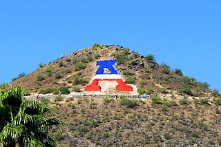
Sentinel Peak is a 2,897 ft (900 m) peak in the Tucson Mountains southwest of downtown Tucson, Arizona, United States. The valley's first inhabitants grew crops at the mountain's base, along the Santa Cruz River. The name "Tucson" is derived from the O'odham Cuk Ṣon, meaning "[at the] base of the black [hill]". In the 1910s, University of Arizona students used local basalt rock to construct a 160 ft (50 m) tall block "A" on the mountain's east face, near its summit, giving the peak its other name, "A" Mountain. The peak is part of a 272-acre park, the largest natural resource park in the City of Tucson.
Sentinel Peak, Sentinel Mountain, or variations, may refer to:

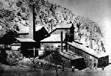
Panamint City is a ghost town in the Panamint Range, near Death Valley, in Inyo County, California, US. It is also known by the official Board of Geographic Names as Panamint. Panamint was a boom town founded after silver and copper were found there in 1872. By 1874, the town had a population of about 2,000. Its main street was one mile (1.6 km) long. Panamint had its own newspaper, the Panamint News. Silver was the principal product mined in the area. The town is located about three miles northwest of Sentinel Peak. According to the National Geographic Names Database, NAD27 latitude and longitude for the locale are 36°07′06″N117°05′43″W, and the feature ID number is 1661185. The elevation of this location is identified as being 6,280 feet AMSL. The similar-sounding Panamint Springs, California, is located about 25.8 miles at 306.4 degrees off true north near Panamint Junction.

Sugarloaf Ridge State Park is a state park in Northern California, United States. Located in the Mayacamas Mountains north of Kenwood, the park straddles the boundary between Sonoma and Napa counties. The park contains the 2,729-foot (832 m) Bald Mountain and the headwaters of Sonoma Creek including a 25-foot (8 m) tall seasonal waterfall. The park is also home to the volunteer-run Robert Ferguson Observatory. Camping, picnicking, horseback riding, mountain biking, stargazing, fishing and hiking are common attractions of Sugarloaf. The park boasts 25 miles of trails with trails ranging from less than a mile to 8.8 miles, and elevation gains reaching 2,500 feet.

Sentinel Rock is a granitic peak in Yosemite National Park, California, United States. It towers over Yosemite Valley, opposite Yosemite Falls. Sentinel Rock lies 0.7 miles (1.1 km) northwest of Sentinel Dome.

The Growler Mountains is a 23-mile, (37-km) long north-south trending mountain range of far western Pima County, Arizona that lies 12 miles (19 km) west of Ajo, Arizona. This desert region of southern Arizona lies in the north and central Sonoran Desert, and is one of the drier desert areas of North America.

Roché Glacier is the 5.8 km long and 2 km wide glacier draining the central part of Vinson Plateau in Sentinel Range, Ellsworth Mountains in Antarctica. Its head is bounded by Mount Vinson to the north, Corbet Peak and Clinch Peak to the east, Wahlstrom Peak to the southeast, and Hollister Peak to the south, with the glacier flowing westwards and descending steeply north of Silverstein Peak to join Branscomb Glacier.

Newcomer Glacier is a glacier 20 nautical miles long transecting the north part of the Sentinel Range, flowing from the vicinity of Allen Peak southeast between Gromshin Heights and the main ridge of range, and then east between Gromshin Heights and Sostra Heights to where it leaves the Sentinel Range north of Bracken Peak and south of Foros Spur. Named by the Advisory Committee on Antarctic Names (US-ACAN) for Commander Loyd E. Newcomer of U.S. Navy Squadron VX-6, pilot on photographic flights over the range on December 14–15, 1959.

Patton Glacier is a broad tributary glacier in the Sentinel Range, Ellsworth Mountains. It drains the east slope of the main ridge between Mounts Ostenso and Tyree, flows east-northeastwards between Evans Peak and Versinikia Peak on the north and Mount Bearskin on the south, and enters Ellen Glacier northeast of Zalmoxis Peak and southeast of Mount Jumper.

Donnellan Glacier is a steep valley glacier fed by highland ice adjacent to Opalchenie Peak and Fukushima Peak on Vinson Plateau, the summit plateau of Vinson Massif, in the Sentinel Range of the Ellsworth Mountains, Antarctica. The glacier flows west-southwestward from Opalchenie Peak along the northwest side of Mount Slaughter into Nimitz Glacier.
Sentinel Peak is located near Johnsondale, California. It is a popular with Boy Scouts visiting Camp Whitsett, with several hundred scouts hiking the mountain each week in the summer. It is in Giant Sequoia National Monument and Sequoia National Forest.

Tulaczyk Glacier is a steep valley glacier draining the west slope of Vinson Massif southwest of Príncipe de Asturias Peak, and descending between Cairns Glacier and Zapol Glacier in the Sentinel Range, Antarctica. The glacier flows southwestward and leaving the range, together with Cairns Glacier joins Nimitz Glacier west of Hodges Knoll and southeast of Klenova Peak. It was named by US-ACAN (2006) after Slawek M. Tulaczyk, Earth Sciences, University of California, Santa Cruz; USAP researcher of West Antarctic ice streams from 1998.

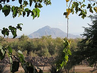
Mount Signal is a mountain 20 km (12 mi) west of Mexicali, Baja California, Mexico, on Mexican Federal Highway 2. The peak is also known as "Weeishpa" by the native community Kumiai or "Cerro del Centinela" or simply: El Centinela by the Mexicans. The northern slope of the mountain begins at the border between Mexico and the United States, the south side is bordered by Federal Highway 2. It has an elevation of about 781 meter and is the northernmost peak of the Cocopah mountain range or sierra cucapá.

Grand Sentinel is an 8,518-foot-elevation (2,596-meter) pillar located west of the crest of the Sierra Nevada mountain range, in Kings Canyon National Park, in Fresno County of northern California. This landmark is situated at the northern end of the Great Western Divide, two miles west-northwest of The Sphinx, and immediately south of Kanawyers and Zumwalt Meadow. Topographic relief is significant as the north aspect rises nearly 3,500 feet above the canyon floor in one-half mile. This feature's name has been officially adopted by the United States Board on Geographic Names.


