Springfield metropolitan area, Missouri

Last updated
Springfield metropolitan area, Missouri
Springfield, Missouri Metropolitan Statistical Area
Springfield metropolitan area, Missouri
Interactive Map of Springfield, MO MSA
Coordinates: 37°21′42″N93°10′37″W / 37.3617°N 93.1769°W / 37.3617; -93.1769
Country Flag of United States.svg United States
State Flag of Virginia.svg Virginia
Principal city Springfield
Other cities Battlefield
Nixa
Ozark
Republic
Marshfield
Bolivar
Willard
Area
  Total3,021 sq mi (7,820 km2)
Population
 (2020 census)
  Total475,432
  Rank 117th in the U.S.
Time zone UTC−7 (CST)
  Summer (DST) UTC−6 (CDT)
Historical population
CensusPop.Note
1960 126,274
1970 152,92921.1%
1980 207,70435.8%
1990 240,59315.8%
2000 368,37453.1%
2010 436,71218.6%
2020 475,4328.9%

The Springfield, Missouri, metropolitan area, as defined by the United States Census Bureau, is an area consisting of five counties in southwestern Missouri, anchored by the city of Springfield, the state's third largest city. [1] Other primary population centers in the metro area include Nixa, Ozark, Republic, Bolivar, Marshfield and Willard. Currently, the city limits of Springfield reach the Nixa, and Ozark city limits at the Christian County line on US 160, and US 65 respectively, the city limits of Republic at James River Freeway on the southwest side of the city, and the Strafford city limits on Route 744 on the northeast side of the city.

Contents

As of the 2020 census, the MSA (Metropolitan Statistical Area) had a population of 475,432 and was the fastest growing metro area in the state of Missouri. [2] The area is home to several centers for higher education, including Missouri State University, Drury University and Southwest Baptist University. The Springfield region serves as the headquarters for various companies and organizations, including Bass Pro Shops, BKD, LLP, O'Reilly Auto Parts, Jack Henry & Associates, Andy's Frozen Custard and CoxHealth, and also serves as an important location for JPMorgan Chase, [3] Expedia and American Airlines. [4] As of 2019, the Springfield metro had a GDP of US$20.8 billion, the third largest in Missouri. [5]

Counties

Springfield Metropolitan Statistical Area
County2023 Census Estimate2020 Census2010 CensusChange
Greene County 304,611298,915275,174+8.63%
Christian County 94,42288,84277,422+14.75%
Webster County 41,47239,08536,202+7.96%
Polk County 32,78031,51931,137+1.23%
Dallas County 17,76817,07116,777+1.75%
Total491,053475,432436,712+8.87%

Communities

Anchor cities

Places with 5,000 to 20,000 inhabitants

Places with 5,000 to 20,000 inhabitants

Places with 500 to 1,000 inhabitants

Places with less than 500 inhabitants

Unincorporated places

Satellite view of Springfield Springfield mo aerial map.jpg
Satellite view of Springfield

School systems

Economy

Springfield is the headquarters for O'Reilly Auto Parts, the only Fortune 500 company based in the region. [6] It also houses the headquarters for Bass Pro Shops, CoxHealth, Andy's Frozen Custard, BKD, LLP and Jack Henry & Associates. The Springfield–Branson National Airport serves as a base for American Airlines and Envoy Air as the airline utilizes the airport as a maintenance base. [7] Springfield is also an important region for call centers, with Expedia, Chase and AT&T maintaining call centers in the city. [8]

Media

Springfield serves as the center of the Springfield media market, the 75th largest media market in the country ranked amongst Omaha, Nebraska and Rochester, New York. [9] There are nearly 430,000 television owning homes and a total population of 1,065,000 people. [10]

Print

The main newspaper for the area is the Springfield News-Leader. The area is also served by the Springfield Business Journal and 417 magazine as well as its specialized magazines including 417 Biz.

Surrounding areas are served by their own newspapers as well, Christian County communities are served by Headliner News, [11] Marshfield by The Marshfield Mail, [12] and Bolivar by the Herald Free-Press. [13]

Broadcast

Television stations in the Springfield metro area include:

Education

Secondary

Central High School in Springfield Central high school springfield missouri.tif
Central High School in Springfield

Springfield Public Schools is the largest fully accredited school district in the State of Missouri with nearly 25,000 students and a graduation rate of roughly 88%. [14] Nixa Public Schools, located just south of Springfield, is a growing district of 6,000 students that frequently ranks above the national average in ACT scores and has for the last ten years earned the highest state recognition for academic achievement given in Missouri. [15] Other growing districts in the area are located in the cities of Ozark, Republic, Strafford, and Marshfield. Private schools in the area include the Greenwood Laboratory School in Springfield, located on the Missouri State campus, and the Summit Preparatory School, located near James River Freeway in Chesterfield Village.

Meyer Library at Missouri State University Campus MissouriStateUniversityMeyerCarillon.jpg
Meyer Library at Missouri State University Campus

There are also several private religious schools in the area, including Springfield Catholic and Springfield Lutheran. [16]

Colleges and universities

Missouri State University in Springfield is the second largest university in the state with roughly 23,697 in 2019. Other universities in Springfield include Drury University, a private liberal arts college with more than 1,000 students, and OTC with approximately 11,000 students, where students can earn a one-year certificate or a two-year associate degree.

Transportation

Principal Highways

Air

Allegiant Air flight departing from Springfield Allegiant Air - N418NV (8215677315).jpg
Allegiant Air flight departing from Springfield

The area is served by Springfield-Branson National Airport which has direct flights on Delta, United, American and Allegiant to thirteen cities across the United States, including hubs such as Chicago, Dallas, Atlanta, Charlotte and Houston, among others. With over one million passengers per year prior to the COVID-19 pandemic, [17] it is one of the fastest growing airports of its size in the country. [18] A new terminal was opened at the airport in 2007 with 10 gates, expandable to 60, and runways can accommodate the Boeing 747 and large military aircraft.

Springfield has a secondary, smaller airport, Downtown Airport which is not served by any passenger airlines and is used mostly by smaller general aviation airplanes.

Public transportation

Public transportation in the metropolitan area is focused primarily in Springfield. City Utilities of Springfield operates Springfield Transit Services, operating many buses on several different routes throughout the city, and bus service is available 365 days per year with less frequent weekend, holiday and evening routes.

Greenways

The area has a growing number of Greenway trails, 70 miles (112 km) run through parks and green areas, while 81 miles (130 km) are located on city streets. [19] Such routes include The Link, which runs on local roads through the city of Springfield, and the Trail of Tears Link, while the Frisco Link connects Springfield with Bolivar to the north.

See also

Related Research Articles

<span class="mw-page-title-main">Webster County, Missouri</span> County in Missouri, United States

Webster County is a county located in the U.S. state of Missouri. As of the 2020 census, the population was 39,085. Its county seat is Marshfield. The county was organized in 1855 and named for U.S. Senator and U.S. Secretary of State Daniel Webster.

<span class="mw-page-title-main">Taney County, Missouri</span> County in Missouri, United States

Taney County is a county in the southwestern portion of the U.S. state of Missouri. As of the 2020 census, the population was 56,066. Its county seat is Forsyth. It is included in the Branson, Missouri, Micropolitan Statistical Area.

<span class="mw-page-title-main">Greene County, Missouri</span> County in Missouri, United States

Greene County is located in the southwest part of the U.S. state of Missouri. As of the 2020 census, its population was 298,915. making it the fourth most-populous county in Missouri.

<span class="mw-page-title-main">Christian County, Missouri</span> County in Missouri, United States

Christian County is located in the southwestern part of the U.S. state of Missouri. As of the 2020 census, its population was 88,842. Its county seat is Ozark. The county was organized in 1859 and is named after Christian County, Kentucky, it being named for William Christian, a Kentucky soldier of the American Revolutionary War.

<span class="mw-page-title-main">Nixa, Missouri</span> City in Missouri, United States

Nixa is a city in Christian County, Missouri, United States. As of the 2020 census, the city's population was 23,257. It is a principal city, and the second largest city in the Springfield, Missouri Metropolitan Statistical Area.

<span class="mw-page-title-main">Ozark, Missouri</span> City in Missouri, United States

Ozark is a city in and the county seat of Christian County, Missouri. Its population was 21,284 as of the 2020 census. Ozark is also the third largest city in the Springfield, Missouri Metropolitan Area, and is centered along a business loop of U.S. Route 65, where it intersects with Missouri Route 14.

<span class="mw-page-title-main">Buffalo, Missouri</span> City in Missouri, United States

Buffalo is a city in and the county seat of Dallas County, Missouri, United States. The population was 3,290 at the 2020 census.

<span class="mw-page-title-main">Osage Beach, Missouri</span> City in Missouri, United States

Osage Beach is a city in Camden and Miller counties in the U.S. state of Missouri, near the Lake of the Ozarks. Most of the city is in Camden County, while a small eastern sliver is in Miller County. The population was 4,792 at the 2020 census.

<span class="mw-page-title-main">Springfield, Missouri</span> City in Missouri, United States

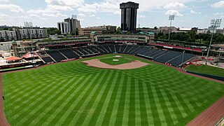
Springfield is the third most populous city in the U.S. state of Missouri and the county seat of Greene County. The city's population was 169,176 at the 2020 census. It is the principal city of the Springfield metropolitan area, which had an estimated population of 487,061 in 2022 and includes the counties of Christian, Dallas, Greene, Polk, and Webster, The city sits on the Springfield Plateau of the Ozarks, which ranges from nearly-level to rolling hills. Springfield is the second-largest urban area in the Ozarks.

<span class="mw-page-title-main">Rogersville, Missouri</span> City in Missouri, United States

Rogersville is a city in Greene and Webster counties in the U.S. state of Missouri. The population is 3,897 as of the 2020 census. It is part of the Springfield, Missouri Metropolitan Statistical Area. Rogersville was formerly known as the "Raccoon Capital of the World". In 2006, 417 Magazine ranked Rogersville as the eighth-best place to live in Southwest Missouri.

<span class="mw-page-title-main">Branson, Missouri</span> City in Missouri, United States

Branson is a city in the U.S. state of Missouri. Most of the city is situated in Taney County, with a small portion in the west extending into Stone County. Branson is in the Ozark Mountains. The community was named after Reuben Branson, postmaster and operator of a general store in the area in the 1880s. The population was 12,638 at the 2020 census.

<span class="mw-page-title-main">Missouri Route 13</span> State highway in Missouri

Route 13 is a highway in Missouri which runs almost the entire north–south length of the state. Its northern terminus is at U.S. Route 69/136 in Bethany. Its southern terminus is at the Arkansas state line in downtown Blue Eye, Missouri–Arkansas where it continues as Highway 21. It is one of the original state highways of Missouri.

<span class="mw-page-title-main">KYTV (TV station)</span> NBC affiliate in Springfield, Missouri

KYTV is a television station in Springfield, Missouri, United States, affiliated with NBC. It is owned by Gray Television alongside ABC affiliate KSPR-LD and Branson-licensed CW affiliate KYCW-LD ; it is also sister to Branson-licensed tourist information–formatted station K17DL-D, channel 17. KYTV, KSPR-LD and KYCW-LD share studios on West Sunshine Street in Springfield, while KYTV's transmitter is located on Highway FF north of Fordland.

<span class="mw-page-title-main">Area code 417</span> Telephone area code for southwestern Missouri, United States

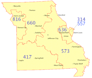
Area code 417 is a telephone area code in the North American Numbering Plan (NANP) for the southwestern quadrant of Missouri, including the cities of Branson, Carl Junction, Carthage, Joplin, Lebanon, Neosho, Nixa, Ozark, Springfield, and West Plains. Area code 417 was created in 1951 as a split from area code 816.

James River Freeway is a 14-mile-long (23 km) freeway located largely on the south side of Springfield, Missouri. Its western terminus is at Interstate 44 (I-44) north of Brookline and its eastern terminus is at U.S. Route 65 (US 65) in southeastern Springfield. It is named for the James River, which passes near the highway at the freeway's eastern terminus. A total of four highways are routed on the highway: Route 360, US 60, US 160, Route 13, and Business US 65.

<span class="mw-page-title-main">Special routes of U.S. Route 65</span>

A total of eight special routes of U.S. Route 65 exist, divided between the U.S. states of Arkansas and Missouri. Currently, they are all business loops, although a spur route in Pine Bluff, Arkansas and bypass routes in Baton Rouge, Louisiana and Springfield, Missouri both existed in the past.

Northland Center for Advanced Professional Studies (CAPS) is a high school program which operates multiple different magnet programs for students who live within the school districts of: Excelsior Springs, Kearney, Liberty, North Kansas City, Park Hill, Platte County, and Smithville.

<span class="mw-page-title-main">Logan-Rogersville High School</span> Public school in Rogersville, Missouri

Logan-Rogersville High School (LRHS) is a public high school for grades 9–12 located in Rogersville, Missouri as part of the Logan-Rogersville R-VIII School District. The National Center for Education Statistics classifies LRHS as a "rural fringe" locale, which is defined as a rural area that is less than or equal to 5 miles from an urban area. The mascot of LRHS is the wildcat with the colors of maroon and white.

<span class="mw-page-title-main">U.S. Route 60 in Missouri</span> Segment of American highway

U.S. Route 60 (US 60) is a part of the United States Numbered Highway System that runs from Brenda, Arizona, east to Virginia Beach, Virginia. In the state of Missouri, US 60 is a main east–west highway that runs through the southern part of the state, from the Oklahoma border to the Illinois border.

References

  1. "OMB Bulletin No. 18-04: Update of Statistical Area Definitions and Guidance on Their Uses" (PDF). United States Office of Management and Budget. September 14, 2018. Retrieved March 3, 2019.
  2. Riley, Claudette. "Springfield is fastest-growing metro area in Missouri — even outpacing Kansas City — according to a report". Springfield News-Leader. Retrieved 2021-12-09.
  3. "Chase plans 300 more hires on 20th anniversary in Springfield". Springfield Business Journal. 8 January 2018. Retrieved 2021-12-09.
  4. "$11M airport project to expand American operations". Springfield Business Journal. 3 February 2021. Retrieved 2021-12-09.
  5. "Metropolitan Gross Domestic Product Data Series | Missouri Economic Research and Information Center". meric.mo.gov. Retrieved 2021-12-09.
  6. "O'Reilly Auto climbs 46 spots on Fortune 500". Springfield Business Journal. 3 June 2021. Retrieved 2021-12-30.
  7. Taylor, Abbey (14 December 2021). "Springfield-Branson National Airport opens new maintenance hangar for Envoy Air". ky3.com. Retrieved 2021-12-30.
  8. Partnership (SREP), Springfield Regional Economic. "Call Centers & Back Office". Springfield Regional Economic Partnership. Retrieved 2021-12-30.
  9. "Springfield DMA Map 2021". Media Market Map. 2021-09-28. Retrieved 2021-12-14.
  10. "TRUCK ADS | Springfield Designated Market Map | ADMAP | Truckside Ads". www.truckads.com. Retrieved 2021-12-14.
  11. "Christian County Headliner News". ccheadliner.com. Retrieved 2021-12-14.
  12. "Marshfield Mail". marshfieldmail.com. Retrieved 2021-12-14.
  13. "Bolivar Herald Free-Press". bolivarmonews.com. Retrieved 2021-12-14.
  14. http://www.springfieldpublicschoolsmo.org/pages/SPSMO/DistrictInfo/Quality_Improvement___Accounta/QIA_Links/Demographic_Data
  15. "Nixa Area Chamber". www.nixachamber.com. Retrieved 8 April 2018.
  16. Departika, Creativore. "Live in Springfield Missouri - Private K-12". www.liveinspringfieldmo.com. Retrieved 8 April 2018.
  17. Simmons, Linda (Dec 6, 2018). "Springfield-Branson National Airport tops 1 million passengers for 2018" . Retrieved Dec 9, 2021.
  18. News, reporter Emily Wood and videographer Tim Leimkuhler, KY3 (25 May 2017). "Springfield - Branson National Airport likely will reach 1 million passengers in 2017". ky3.com. Retrieved 8 April 2018.{{cite web}}: |last= has generic name (help)CS1 maint: multiple names: authors list (link) CS1 maint: numeric names: authors list (link)
  19. "Ozark Greenways, Inc. - American Trails". www.americantrails.org. Retrieved 2021-12-09.