Apple Creek (Mississippi River tributary)

Last updated
Apple Creek
Apple Creek sign from Highway 61.jpg
Apple Creek (stream) sign from Highway 61
Etymology French: Rivière à la Pomme meaning "Apple River"
Location
Country United States
State Missouri
Physical characteristics
Source 
  coordinates 37°38′13″N89°58′33″W / 37.63694°N 89.97583°W / 37.63694; -89.97583
  elevation820 [1]  ft (250 m)
Mouth Mississippi River
  coordinates
37°33′56″N89°31′37″W / 37.56556°N 89.52694°W / 37.56556; -89.52694 Coordinates: 37°33′56″N89°31′37″W / 37.56556°N 89.52694°W / 37.56556; -89.52694
  elevation
322 ft (98 m)
[2]

Apple Creek is a stream that rises in western Perry County, Missouri and empties into the Mississippi River, forming the boundary between Perry and Cape Girardeau counties.

Contents

Name

The name of Apple Creek derives from the French name Rivière à la Pomme. Since the Shawnee Indians cultivated farms and had a number of villages along this creek, it is probable that the early French travelers and hunters gave the name "Rivière à la Pomme" (later Americanized to Apple River or Apple Creek), from the apple trees which grew there. [3]

History

Although it is not known who the original native inhabitants were of the Apple Creek area, the area eventually become home to the Shawnee and Delaware Indians. Having originated in present-day Delaware and Pennsylvania, the Shawnee and Delaware Indians had been pushed off their lands by white settlement. [4] The Spanish encouraged Shawnee and Delaware immigration, and granted them two large tracts of land in the Apple creek watershed, with the intention of the Shawnee and Delaware acting as a buffer against the Osage Indians, who were not on friendly terms with the Spanish authorities. [4] Some 1,200 Shawnee and 600 Delaware were convinced to relocate to the Apple Creek watershed, and in 1784 the group of Shawnee and Delaware migrated and settled down in the area of Old Appleton. The "Grand Village Sauvage" was to the west of present-day Old Appleton and the "Petit Village Sauvage" was to the east of Old Appleton. [5] [6] In the early 1800s, American settlers began encroaching on the Shawnee and Delaware lands around Apple Creek. The Shawnee also requested the Spanish authorities to grant them protection from the Osage in 1807.

By 1815 the situation with white settlers had worsened so much that territorial governor William Clark and United States President James Madison ordered all white intruders removed from Shawnee and Delaware lands. However, this order was largely ignored by the authorities. By 1816, the encroachment by white settlers left the US Federal Government no choice but to relocate the Shawnee and Delaware to lands further west. [7] [8]

Physical geography

The headwaters of Apple Creek arise just east of Missouri Route 51 approximately five miles southwest of Perryville. The stream flows generally southeast past the communities of Millheim and Biehle and crosses into the northwest corner of Cape Girardeau County and meanders past the community of Friedheim back to the northeast to become the county boundary between Cape Girardeau and Perry counties. The stream crosses under I-55 and U.S. Route 61 south of Uniontown and continues east to enter the Mississippi River between Neely's Landing to the south and Grand Tower to the north. [9]

Apple Creek has a number of tributaries: [10]

Cultural geography

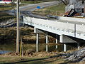
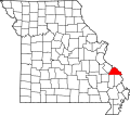
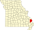
Apple Creek rises in the southern part of Perry County and flows east to form the boundary line between Perry and Cape Girardeau counties. A number of bridges cross Apple Creek, including Apple Creek CR 630 bridge the Apple Creek Railroad bridge, the wrought-iron Old Appleton Bridge, and the pony truss Old Appleton US 61 Bridge. A town by the same name lies north of Apple Creek in Perry County, Missouri. The town of Old Appleton, Missouri, was also earlier known as Apple Creek, but changed its name to Old Appleton in the years leading up to the establishment of its post office in 1876. [3] [11]

Communities

Related Research Articles

Perry County, Missouri County in Missouri, United States

Perry County is a county located in the southeastern portion of the U.S. state of Missouri. As of the 2020 United States census, the population was 18,956. Its county seat is Perryville. The county was officially organized on November 16, 1820 from Ste. Genevieve County and was named after Oliver Hazard Perry, a naval hero of the War of 1812.

Bollinger County, Missouri County in Missouri, United States

Bollinger County is a county located in the southeastern part of the U.S. state of Missouri. As of the 2020 census, the county's population was 10,567. The county seat is Marble Hill. The county was officially organized in 1851.

Pocahontas, Missouri Village in Missouri, United States

Pocahontas is a village in Cape Girardeau County, Missouri, United States. The population was 114 at the 2010 census. It is part of the Cape Girardeau–Jackson, MO-IL Metropolitan Statistical Area.

Biehle, Missouri Census-designated place in Missouri, United States

Biehle was a village in Perry County, Missouri, United States. The population was 48 at the 2010 census. The community was founded in 1876 and named after the Biehle family.

Old Appleton, Missouri Village in Missouri, United States

Old Appleton is a village in Cape Girardeau County, Missouri, United States. The population was 85 at the 2010 census. It is part of the Cape Girardeau–Jackson, MO-IL Metropolitan Statistical Area.

Cape Girardeau, Missouri City in Missouri, United States

Cape Girardeau is a city in Cape Girardeau and Scott Counties in the U.S. state of Missouri. At the 2020 census, the population was 39,540. The city is the economic center of rural Southeast Missouri and also an emerging college town as the home of Southeast Missouri State University. It is located approximately 100 miles (161 km) southeast of St. Louis and 150 miles (241 km) north of Memphis.

Geography of Missouri

Missouri, a state near the geographical center of the United States, has three distinct physiographic divisions:

Pierre-Louis de Lorimier Colonial French-Canadian fur trader (1748–1812)

Pierre-Louis de Lorimier, usually Anglicized to Peter Loramie, was a colonial French-Canadian fur trader, British Indian agent, Shawnee agitator, and in later years, founded Cape Girardeau and Bollinger Counties, Missouri. He died in Cape Girardeau, MO. and was buried there with his Indian wife.

Black Bob was a Native American Shawnee Chief. His band was a part of the Hathawekela division of the Shawnee. He was known for being one of the last Shawnee to resist leaving for the Indian Territory, and for keeping his band together until his death, holding their lands in common, as they moved between Missouri, Arkansas, and the Black Bob Reservation in Kansas.

Apple Creek, Missouri Unincorporated community in Missouri, United States

Apple Creek is an unincorporated community in south central Perry County, Missouri, United States, though not to be confused with the town of Old Appleton which was originally known as Apple Creek. The community is just north of Missouri Route F between I-55 to the west and U.S. Route 61 to the east. Uniontown lies two miles east on Route 61.

Cinque Hommes Township, Perry County, Missouri Civil Township in Missouri, United States

Cinque Hommes is one of the eight townships located in Perry County, Missouri, in the United States of America.

Bois Brule Township, Perry County, Missouri Civil Township in Missouri, United States

Bois Brûlé is one of the eight townships located in Perry County, Missouri, in the United States of America.

Union Township, Perry County, Missouri Civil Township in Missouri, United States

Union is one of the eight townships located in Perry County, Missouri, in the United States of America.

Le Grand Village Sauvage, Missouri Abandoned village in Missouri, United States

Le Grand Village Sauvage, also called Chalacasa, was a Native American village located near Old Appleton in Perry County, Missouri, United States.

Shawneetown, Missouri Unincorporated community in Missouri, United States

Shawneetown is an unincorporated community in Shawnee Township in northern Cape Girardeau County, Missouri, United States. It is located twenty miles north of Cape Girardeau and is part of the Cape Girardeau–Jackson, MO-IL Metropolitan Statistical Area.

Le Grand Champ Bottom

Le Grand Champ is is an alluvial floodplain, also called a bottom, extending along the Mississippi River in Ste. Genevieve County, Missouri.

U.S. Route 54 in Missouri is a west-east highway that starts from the Kansas state line in Nevada to the Illinois state line in Louisiana.

References

  1. Peryville West, Missouri, 7.5 Minute Topographic Quadrangle, USGS, 1980
  2. U.S. Geological Survey Geographic Names Information System: Apple Creek (Mississippi River tributary)
  3. 1 2 "1. Apple Creek: the Name – BÜRCKBÜCHLER Genealogy" . Retrieved 2013-11-27.
  4. 1 2 "Ozark NSR: A Homeland and Hinterland (Chapter 2)". Nps.gov. 2005-03-02. Retrieved 2013-11-27.
  5. Louis Houck (1908). "A History of Missouri: From the Earliest Explorations and Settlements Until the Admission of the State Into the Union". R. R. Donnelley & Sons Company: 213. shawnee villages apple creek history missouri.{{cite journal}}: Cite journal requires |journal= (help)
  6. "Shawnee and Delaware - Jefferson National Expansion Memorial (U.S. National Park Service)". Nps.gov. 2013-11-14. Retrieved 2013-11-27.
  7. Walter A. Schroeder (2002). Opening the Ozarks: A Historical Geography of Missouri's Ste. Genevieve District, 1760–1830. ISBN   9780826263063.
  8. Federal Writers' Project (1941). Missouri: A Guide to the Show Me State. ISBN   9781623760243.
  9. Missouri Atlas & Gazetteer, DeLorme, 1998, First edition, p. 58, ISBN   0-89933-224-2
  10. Garland Carr Broadhead; Fielding Bradford Meek; Benjamin Franklin Shumard (1873). Reports on the Geological Survey of the State of Missouri: 1855–1871. Regan & Carter, printers and binders. p.  283. apple creek indian creek perry county missouri.
  11. Robert Sidney Douglass (1912). History of Southeast Missouri: A Narrative Account of Its ..., Volume 1. ISBN   9780722207536.