Bonanza Mountain Estates, Colorado

Last updated
Bonanza Mountain Estates, Colorado
Boulder County Colorado Incorporated and Unincorporated areas Bonanza Mountain Estates Highlighted 0807580.svg
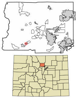
Location of the Bonanza Mountain Estates CDP in Boulder County, Colorado.
Usa edcp location map.svg
Red pog.svg
Bonanza Mountain Estates
Location of Bonanza Mountain Estates, Colorado.
USA Colorado location map.svg
Red pog.svg
Bonanza Mountain Estates
Bonanza Mountain Estates (Colorado)
Coordinates: 39°58′36″N105°28′49″W / 39.9767°N 105.4803°W / 39.9767; -105.4803 [1]
Country United States of America
State State of Colorado
County Boulder County [2]
Government
  Type unincorporated community
  Body Boulder County [2]
Area
[3]
  Total
0.168 sq mi (0.436 km2)
  Land0.168 sq mi (0.436 km2)
  Water0.000 sq mi (0.000 km2)
Elevation
[1]
8,445 ft (2,574 m)
Population
 (2020) [4]
  Total
127
  Density750/sq mi (290/km2)
Time zone UTC−07:00 (MST)
  Summer (DST) UTC−06:00 (MDT)
ZIP Code [5]
Nederland 80466
Area codes 303/720/983
GNIS pop ID 197908
GNIS town ID 2583214
FIPS code 08-07580

Bonanza Mountain Estates is an unincorporated community and a census-designated place (CDP) located in Boulder County, Colorado, United States. The CDP is a part of the Boulder, CO Metropolitan Statistical Area. The population of the Bonanza Mountain Estates CDP was 127 at the United States Census 2020. [4] The Nederland post office (Zip Code 80466) serves the area. [5]

Contents

Geography

The CDP is a residential community located in southern Boulder County in the Front Range of the Colorado Rocky Mountains, just east of the town of Nederland. It is situated on a ridge between Middle Boulder Creek and North Boulder Creek. Ridge Road is the main street through the community, leading west to Nederland and east to St. Ann Highlands.

At the 2020 United States Census, the Bonanza Mountain Estates CDP had an area of 108 acres (0.436 km2), all land. [6]

Demographics

The United States Census Bureau initially defined the Bonanza Mountain Estates CDP for the United States Census 2010.

Bonanza Mountain Estates CDP, Colorado
YearPop.±%
2010 128    
2020 127−0.8%
Source: United States Census Bureau

See also

Related Research Articles

<span class="mw-page-title-main">Todd Creek, Colorado</span> Census Designated Place in Colorado, United States

Todd Creek is an unincorporated community and a census-designated place (CDP) located in and governed by Adams County, Colorado, United States. The CDP is a part of the Denver–Aurora–Lakewood, CO Metropolitan Statistical Area. The population of the Todd Creek CDP was 5,028 at the United States Census 2020. The Todd Creek Village Metropolitan District and the Todd Creek Village Park and Recreation District provide services to the community, which lies in ZIP Code 80602.

<span class="mw-page-title-main">Eldora, Colorado</span> Census Designated Place in Colorado, United States

Eldora, previously known as "Eldorado" then "El-Dora", then Eldora or Camp Eldorado, and still called Happy Valley, is an unincorporated community and a census-designated place (CDP) located in and governed by Boulder County, Colorado, United States. The CDP is a part of the Boulder, CO Metropolitan Statistical Area. The population of the Eldora CDP was 140 at the United States Census 2020. The Nederland post office serves the area.

<span class="mw-page-title-main">Rollinsville, Colorado</span> Census-designated place in Gilpin County, Colorado, United States

Rollinsville is a census-designated place (CDP) and post office in and governed by Gilpin County, Colorado, United States. The CDP is a part of the Denver–Aurora–Lakewood, CO Metropolitan Statistical Area. The Rollinsville post office has the ZIP Code 80474. At the United States Census 2020, the population of the Rollinsville CDP was 194.

<span class="mw-page-title-main">Cherry Creek, Colorado</span> Census Designated Place in Colorado, United States

Cherry Creek is an unincorporated community and a census-designated place (CDP) located in and governed by Arapahoe County, Colorado, United States. The CDP is a part of the Denver–Aurora–Lakewood, CO Metropolitan Statistical Area. The population of the Cherry Creek CDP was 11,488 at the United States Census 2020. The ZIP code 80111 serves the area.

<span class="mw-page-title-main">Idledale, Colorado</span> Census Designated Place in Colorado, United States

Idledale is an unincorporated town, a post office, and a census-designated place (CDP) located in and governed by Jefferson County, Colorado, United States. The CDP is a part of the Denver–Aurora–Lakewood, CO Metropolitan Statistical Area. The Idledale post office has the ZIP code 80453. At the United States Census 2020, the population of the Idledale CDP was 244.

<span class="mw-page-title-main">Altona, Colorado</span> A census-designated place in Boulder County, Colorado, United States

Altona is an unincorporated community and a census-designated place (CDP) located in and governed by Boulder County, Colorado, United States. The CDP is a part of the Boulder, CO Metropolitan Statistical Area. The population of the Altona CDP was 512 at the United States Census 2020. The Boulder post office serves the area.

<span class="mw-page-title-main">Comanche Creek, Colorado</span> Census Designated Place in Colorado, United States

Comanche Creek is an unincorporated community and a census-designated place (CDP) located in and governed by Arapahoe County, Colorado, United States. The CDP is a part of the Denver–Aurora–Lakewood, CO Metropolitan Statistical Area. The population of the Comanche Creek CDP was 442 at the United States Census 2020. The Strasburg post office serves the area.

<span class="mw-page-title-main">Holly Hills, Colorado</span> Census Designated Place in Colorado, United States

Holly Hills is an unincorporated community and a census-designated place (CDP) located in and governed by Arapahoe County, Colorado, United States. Holly Hills is an enclave of the City and County of Denver. The CDP is a part of the Denver–Aurora–Lakewood, CO Metropolitan Statistical Area. The population of the Holly Hills CDP was 2,683 at the United States Census 2020. The Denver post office 80222 serves the area.

<span class="mw-page-title-main">Dakota Ridge, Colorado</span> Census Designated Place in Colorado, United States

Dakota Ridge is an unincorporated community and a census-designated place (CDP) located in and governed by Jefferson County, Colorado, United States. The CDP is a part of the Denver–Aurora–Lakewood, CO Metropolitan Statistical Area. The population of the Dakota Ridge CDP was 33,892 at the United States Census 2020. In 1988, voters turned down a proposal to incorporate Dakota Ridge. The community lies in ZIP codes 80127 and 80465.

<span class="mw-page-title-main">Bark Ranch, Colorado</span> A Census Designated Place in Boulder County, Colorado, United States

Bark Ranch is an unincorporated community and a census-designated place (CDP) located in and governed by Boulder County, Colorado, United States. The Bark Ranch CDP encompasses the Bar-K Ranch housing community. The CDP is a part of the Boulder, CO Metropolitan Statistical Area. The population of the Bark Ranch CDP was 202 at the United States Census 2020. The Jamestown post office serves the area.

<span class="mw-page-title-main">Glendale, Boulder County, Colorado</span> Census Designated Place in Colorado, United States

Glendale is an unincorporated community and a census-designated place (CDP) located in and governed by Boulder County, Colorado, United States. The CDP is a part of the Boulder, CO Metropolitan Statistical Area. The population of the Glendale CDP was 64 at the United States Census 2020. The Jamestown post office serves the area.

<span class="mw-page-title-main">Hidden Lake, Colorado</span> Census Designated Place in Colorado, United States

Hidden Lake is an unincorporated community and a census-designated place (CDP) located in and governed by Boulder County, Colorado, United States. The CDP is a part of the Boulder, CO Metropolitan Statistical Area. The population of the Hidden Lake CDP was 24 at the United States Census 2020. The Ward post office serves the area.

<span class="mw-page-title-main">Lazy Acres, Colorado</span> Census Designated Place in Colorado, United States

Lazy Acres is an unincorporated community and a census-designated place (CDP) located in and governed by Boulder County, Colorado, United States. The CDP is a part of the Boulder, CO Metropolitan Statistical Area. The population of the Lazy Acres CDP was 957 at the United States Census 2020. The Boulder post office serves the area.

<span class="mw-page-title-main">Mountain Meadows, Colorado</span> Census Designated Place in Colorado, United States

Mountain Meadows is an unincorporated community and a census-designated place (CDP) located in and governed by Boulder County, Colorado, United States. The CDP is a part of the Boulder, CO Metropolitan Statistical Area. The population of the Mountain Meadows CDP was 237 at the United States Census 2020. The Boulder post office serves the area.

<span class="mw-page-title-main">Paragon Estates, Colorado</span> Census Designated Place in Colorado, United States

Paragon Estates is an unincorporated community and a census-designated place (CDP) located in and governed by Boulder County, Colorado, United States. The CDP is a part of the Boulder, CO Metropolitan Statistical Area. The population of the Paragon Estates CDP was 975 at the United States Census 2020. The Boulder post office serves the area.

<span class="mw-page-title-main">Sugarloaf, Colorado</span> Census-Designated Place in Colorado, United States

Sugarloaf is an unincorporated community and a census-designated place (CDP) located in and governed by Boulder County, Colorado, United States. The CDP is a part of the Boulder, CO Metropolitan Statistical Area. The population of the Sugarloaf CDP was 274 at the United States Census 2020. The Boulder post office serves the area.

<span class="mw-page-title-main">St. Ann Highlands, Colorado</span> Census Designated Place in Colorado, United States

St. Ann Highlands or Saint Ann Highlands is an unincorporated community and a census-designated place (CDP) located in and governed by Boulder County, Colorado, United States. The CDP is a part of the Boulder, CO Metropolitan Statistical Area. The population of the St. Ann Highlands CDP was 325 at the United States Census 2020. The Nederland post office serves the area.

Pine Valley is an unincorporated community and a census-designated place (CDP) located in and governed by Clear Creek County, Colorado, United States. The population was 363 at the 2020 census. The CDP is a part of the Denver–Aurora–Lakewood, CO Metropolitan Statistical Area. The Evergreen post office serves the area.

Upper Witter Gulch is an unincorporated community and a census-designated place (CDP) located in and governed by Clear Creek County, Colorado, United States. The population was 347 at the 2020 census. The CDP is a part of the Denver–Aurora–Lakewood, CO Metropolitan Statistical Area. The Evergreen post office serves the area.

Sierra Ridge is an unincorporated community and a census-designated place (CDP) located in and governed by Douglas County, Colorado, United States. The population was 3,490 at the 2020 census. The CDP is a part of the Denver–Aurora–Lakewood, CO Metropolitan Statistical Area. The unincorporated community lies in ZIP Code 80134.

References

  1. 1 2 "Bonanza Mountain Estates, Colorado". Geographic Names Information System . United States Geological Survey, United States Department of the Interior . Retrieved January 28, 2025.
  2. 1 2 "Colorado Counties". Colorado Department of Local Affairs . Retrieved January 28, 2025.
  3. "State of Colorado Census Designated Places - BAS20 - Data as of January 1, 2020". United States Census Bureau . Retrieved December 16, 2020.
  4. 1 2 United States Census Bureau. "Bonanza Mountain Estates CDP, Colorado" . Retrieved April 18, 2023.
  5. 1 2 "Zip Code 80466 Map and Profile". zipdatamaps.com. 2020. Retrieved December 20, 2020.
  6. "State of Colorado Census Designated Places - BAS20 - Data as of January 1, 2020". United States Census Bureau . Retrieved November 23, 2020.