
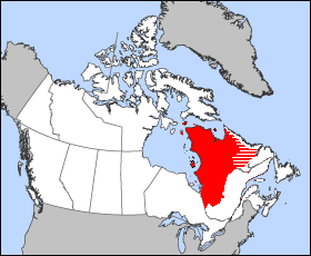
Labrador is a geographic and cultural region within the Canadian province of Newfoundland and Labrador. It is the primarily continental portion of the province and constitutes 71% of the province's area but is home to only 6% of its population. It is separated from the island of Newfoundland by the Strait of Belle Isle. It is the largest and northernmost geographical region in the four Atlantic provinces.

The Strait of Belle Isle is a waterway in eastern Canada, that separates Labrador from the island of Newfoundland, in the province of Newfoundland and Labrador.

The Labrador Peninsula or Quebec-Labrador Peninsula, is a large peninsula in eastern Canada. It is bounded by Hudson Bay to the west, the Hudson Strait to the north, the Labrador Sea to the east, Strait of Belle Isle and the Gulf of St. Lawrence to the southeast. The peninsula includes the region of Labrador, which is part of the province of Newfoundland and Labrador, and the regions of Saguenay–Lac-Saint-Jean, Côte-Nord, and Nord-du-Québec, which are in the province of Quebec. It has an area of 1,400,000 km2 (541,000 sq mi).

St. Anthony is a town on the northern reaches of the Great Northern Peninsula of the Canadian province of Newfoundland and Labrador. St. Anthony serves as a main service centre for northern Newfoundland and southern Labrador. St. Anthony had a population of 2,180 in 2021, compared with 2,258 in 2016, 2,418 in 2011, 2,476 in 2006 and 2,730 in 2001.

L'Anse Amour, romanticized version of Anse aux Morts, is a hamlet located on the north shore of the Strait of Belle Isle, Newfoundland and Labrador, Canada.
The District of Ungava was a regional administrative district of Canada's Northwest Territories from 1895 to 1920, although it effectively ceased operation in 1912. It covered the northern portion of what is today Quebec, the interior of Labrador, and the offshore islands to the west and north of Quebec, which are now part of Nunavut.
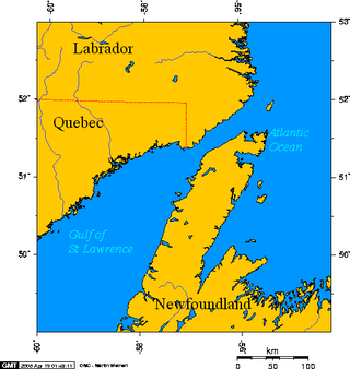
The Newfoundland–Labrador fixed link is any of various proposals for constructing a fixed link consisting of a combination of bridges, tunnels, or causeways across the Strait of Belle Isle, connecting the province of Newfoundland and Labrador's mainland Labrador region with the island of Newfoundland. This strait has a minimum width of 17.4 km.

The Great Northern Peninsula is the largest and longest peninsula of Newfoundland, Canada, approximately 270 km long and 90 km wide at its widest point and encompassing an area of 17,483 km2. It is defined as that part of Newfoundland from Bonne Bay northwards around Cape Norman and Cape Bauld and thence southwards to the head of White Bay, bounded by the Gulf of St. Lawrence on the west, the Strait of Belle Isle on the north and the Labrador Sea and White Bay on the east.

Blanc-Sablon is a municipality located on the shore of Blanc-Sablon Bay, in the Strait of Belle-Isle, Le Golfe-du-Saint-Laurent RCM, Côte-Nord, Quebec, Canada.
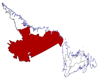
Census Division No. 10 of Newfoundland and Labrador is composed of the Labrador region of the province, excluding Nunatsiavut. It has a land area of 199,703 km² (77,105.8 sq mi) and at the 2016 census had a population of 24,639, up from 24,111 in 2011. Its two major population centres are the towns of Happy Valley-Goose Bay and Labrador City.

Route 430 is a 413-kilometre-long (257 mi) paved highway that traverses the Great Northern Peninsula of Newfoundland in the Canadian province of Newfoundland and Labrador. The route begins at the intersection of Route 1 in Deer Lake and ends in St. Anthony. Officially known as the Great Northern Peninsula Highway, it has been designated as the Viking Trail since it is the main auto route to L'Anse aux Meadows, the only proven Viking era settlement in North America. It is the primary travel route in the Great Northern Peninsula and the only improved highway between Deer Lake and St. Anthony. It is the main access route to the Labrador Ferry terminal in St. Barbe.
L'Anse-au-Clair is a town in the Labrador portion of Newfoundland and Labrador, Canada. The town has a population of 219 in the 2021 census, up from 192 in 2011.

Forteau is a town in the Canadian province of Newfoundland and Labrador. The town had a population of 377 as of the Canada 2021 Census.

Salvage is a town located on the Eastport Peninsula of the Canadian province of Newfoundland and Labrador. The town had a population of 108 in the Canada 2021 Census.

Franco-Newfoundlanders, also known as Franco-Terreneuvians in English or Franco-Terreneuviens in French, are francophone and/or French Canadian residents of the Canadian province of Newfoundland and Labrador. The name Franco-Terreneuvian derives from Terre-Neuve, the French name of Newfoundland.
St. Barbe is an unincorporated settlement in Newfoundland and Labrador. It is located on the Great Northern Peninsula of the island of Newfoundland near Pigeon Cove. St. Barbe and Pigeon Cove together have a population of 135 as of 2016.

Newfoundland is a large island within the Canadian province of Newfoundland and Labrador. It is situated off the eastern coast of the North American mainland and the geographical region of Labrador.
The Point Amour Lighthouse is located on the shore of Forteau Bay, in Strait of Belle Isle, Labrador Peninsula, L'Anse Amour hamlet, in southern Labrador, Newfoundland and Labrador, province, Canada.

The settlement of Basques in the Americas was the process of Basque emigration and settlement in the New World. Thus, there is a deep cultural and social Basque heritage in some places in the Americas, the most famous of which being Saint Pierre and Miquelon, Central America, Guatemala and Antioquia, Colombia.


