Lester, West Virginia

Last updated

Lester, West Virginia
Lester-City-Hall-wv.jpg
City Hall in Lester
Logo of Lester, West Virginia.svg
Raleigh County West Virginia Incorporated and Unincorporated areas Lester Highlighted.svg
Location of Lester in Raleigh County, West Virginia.
Coordinates: 37°44′06″N81°18′05″W / 37.73500°N 81.30139°W / 37.73500; -81.30139
Country United States
State West Virginia
County Raleigh
Area
[1]
  Total0.50 sq mi (1.30 km2)
  Land0.50 sq mi (1.30 km2)
  Water0.00 sq mi (0.00 km2)
Elevation
[2]
2,031 ft (619 m)
Population
 (2020) [3]
  Total337
  Estimate 
(2021) [3]
333
  Density626.75/sq mi (241.86/km2)
Time zone UTC-5 (Eastern (EST))
  Summer (DST) UTC-4 (EDT)
ZIP code
25865
Area code 304
FIPS code 54-46468 [4]
GNIS feature ID2391270 [2]

Lester is a town in Raleigh County, West Virginia, United States. The population was 337 at the 2020 census. [3] The community was named after Champ Lester, a local pioneer. [5]

Contents

Geography

Lester is located at 37°44′5″N81°18′4″W / 37.73472°N 81.30111°W / 37.73472; -81.30111 (37.734740, -81.300985). [6] The town is situated along Surveyor Creek, which is part of the Coal River watershed, and is concentrated around the intersection of state routes 97 and 305. The latter highway connects the town with the Beckley area a few miles to the east.

According to the United States Census Bureau, the town has a total area of 0.50 square miles (1.29 km2), all land. [7]

Demographics

Historical population
CensusPop.Note
1920 412
1930 60947.8%
1940 90949.3%
1950 780−14.2%
1960 626−19.7%
1970 507−19.0%
1980 62623.5%
1990 420−32.9%
2000 322−23.3%
2010 3488.1%
2020 337−3.2%
2021 (est.)333 [3] −1.2%
U.S. Decennial Census [8]

2010 census

At the 2010 census there were 348 people, 143 households, and 95 families living in the town. The population density was 696.0 inhabitants per square mile (268.7/km2). There were 175 housing units at an average density of 350.0 per square mile (135.1/km2). The racial makeup of the town was 83.9% White, 13.8% African American, 0.3% Native American, and 2.0% from two or more races. Hispanic or Latino of any race were 0.3%. [9]

Of the 143 households 31.5% had children under the age of 18 living with them, 51.0% were married couples living together, 8.4% had a female householder with no husband present, 7.0% had a male householder with no wife present, and 33.6% were non-families. 28.7% of households were one person and 15.4% were one person aged 65 or older. The average household size was 2.43 and the average family size was 2.89.

The median age in the town was 40.1 years. 25.3% of residents were under the age of 18; 6.3% were between the ages of 18 and 24; 25% were from 25 to 44; 25.3% were from 45 to 64; and 18.1% were 65 or older. The gender makeup of the town was 49.1% male and 50.9% female.

2000 census

At the 2000 census there were 322 people, 142 households, and 89 families living in the town. The population density was 650.5 inhabitants per square mile (248.6/km2). There were 168 housing units at an average density of 339.4 per square mile (129.7/km2). The racial makeup of the town was 79.81% White, 19.88% African American, and 0.31% from two or more races. [4] Of the 142 households 23.9% had children under the age of 18 living with them, 47.2% were married couples living together, 11.3% had a female householder with no husband present, and 37.3% were non-families. 33.1% of households were one person and 19.0% were one person aged 65 or older. The average household size was 2.27 and the average family size was 2.91.

The age distribution was 20.2% under the age of 18, 9.3% from 18 to 24, 26.1% from 25 to 44, 27.3% from 45 to 64, and 17.1% 65 or older. The median age was 42 years. For every 100 females, there were 86.1 males. For every 100 females age 18 and over, there were 79.7 males.

The median household income was $24,375 and the median family income was $30,938. Males had a median income of $25,208 versus $18,125 for females. The per capita income for the town was $11,026. About 14.6% of families and 15.7% of the population were below the poverty line, including 19.7% of those under age 18 and 19.7% of those age 65 or over.

Related Research Articles

<span class="mw-page-title-main">Linden, Alabama</span> City in Alabama, United States

Linden is a city in and the county seat of Marengo County, Alabama, United States. The population was 1,930 at the 2020 census, down from 2,123 at the 2010 census.

<span class="mw-page-title-main">Astatula, Florida</span> Town in the state of Florida, United States

Astatula is a town in Lake County, Florida, United States. The population was 1,889 at the 2020 census. It is part of the Orlando–Kissimmee–Sanford Metropolitan Statistical Area.

<span class="mw-page-title-main">Glenns Ferry, Idaho</span> City in Idaho, United States

Glenns Ferry is a city in Elmore County, Idaho, United States. The population was 1,293 at the 2020 census. The city is adjacent to Interstate 84 and the Snake River.

<span class="mw-page-title-main">Newberry, Indiana</span> Town in Indiana, United States

Newberry is a town in Cass Township, Greene County, Indiana, United States. The population was 193 at the 2010 census. It is part of the Bloomington, Indiana Metropolitan Statistical Area.

<span class="mw-page-title-main">Derby, Iowa</span> City in Iowa, United States

Derby is a city in Lucas County, Iowa, United States. The population was 90 at the time of the 2020 census.
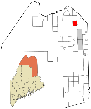
<span class="mw-page-title-main">Merrill, Maine</span> Town in the state of Maine, United States

Merrill is a town in Aroostook County, Maine, United States. The population was 208 at the 2020 census.

Beddington is a town in Washington County, Maine, United States. The population was 60 at the 2020 census. It is the third-smallest organized town in Maine after Frye Island and Frenchboro.

Amity Gardens is a census-designated place (CDP) in Amity Township, Berks County, Pennsylvania. As of the 2020 census, the CDP had a total population of 3,715. The town lends its name to a Fountains of Wayne song.

<span class="mw-page-title-main">Hilda, South Carolina</span> Town in South Carolina, United States

Hilda is a town in Barnwell County, South Carolina, United States. The population was 447 at the 2010 census..

<span class="mw-page-title-main">Kline, South Carolina</span> Town in South Carolina, United States

Kline is a town in Barnwell County, South Carolina, United States. The population was 197 at the 2010 census.

<span class="mw-page-title-main">Gauley Bridge, West Virginia</span> Town in West Virginia, United States

Gauley Bridge is a town in Fayette County, West Virginia, United States. The population was 614 at the 2010 census. The Kanawha River is formed at Gauley Bridge by the confluence of the New and Gauley Rivers. Two miles to the southwest of Gauley Bridge, in Glen Ferris, is Kanawha Falls, a popular stopping point on Midland Trail Scenic Highway.

<span class="mw-page-title-main">Leon, West Virginia</span> Town in West Virginia, United States

Leon is a town in Mason County, West Virginia, United States, situated along the Kanawha River. The population was 137 at the 2020 census. It is part of the Point Pleasant, WV–OH Micropolitan Statistical Area.

<span class="mw-page-title-main">Iaeger, West Virginia</span> Town in West Virginia, United States

Iaeger is a town in McDowell County, West Virginia, United States. The population was 257 at the 2020 census.

<span class="mw-page-title-main">Athens, West Virginia</span> Town in West Virginia, United States

Athens is a town in Mercer County, West Virginia, United States. The population was 944 at the 2020 census. It is part of the Bluefield, WV-VA micropolitan area which has a population of 107,578. Athens is the home of Concord University.

<span class="mw-page-title-main">Bramwell, West Virginia</span> Town in West Virginia, United States

Bramwell is a town in Mercer County, West Virginia, United States, along the Bluestone River. The population was 277 at the 2020 census. It is part of the Bluefield, WV-VA micropolitan area which has a population of 107,578.

<span class="mw-page-title-main">Albright, West Virginia</span> Town in West Virginia, United States

Albright is a town in central Preston County, West Virginia, United States, along the Cheat River. The population was 260 at the 2020 census. A former coal town, it is part of the Morgantown metropolitan area.

<span class="mw-page-title-main">Elizabeth, West Virginia</span> Town in West Virginia, United States

Elizabeth is a town in and the county seat of Wirt County, West Virginia, United States, situated along the Little Kanawha River. The population was 724 as of the 2020 census.

<span class="mw-page-title-main">Oceana, West Virginia</span> Town in West Virginia, United States

Oceana is a town in Wyoming County, West Virginia. The population was 1,462 at the time of the 2020 census. Oceana is the oldest city in Wyoming County and was the county seat until 1907.

<span class="mw-page-title-main">Hale, Wisconsin</span> Town in Wisconsin, United States

Hale is a town in Trempealeau County, Wisconsin, United States. The population was 988 at the 2000 census. The unincorporated communities of Elk Creek, Hale, and Pleasantville are located in the town.

<span class="mw-page-title-main">Kilmarnock, Virginia</span> Town in Virginia, United States

Kilmarnock is a town in Lancaster and Northumberland counties in the U.S. Commonwealth of Virginia. The population was 1,487 at the 2010 census. It is located near the mouth of the Rappahannock River and is located within the Northern Neck George Washington Birthplace American Viticultural Area winemaking appellation. There is a small hospital in the town. Lancaster Middle School, grades 4–8, is also located in town. Approximately 500 students attend the school.

References

  1. "2019 U.S. Gazetteer Files". United States Census Bureau. Retrieved August 7, 2020.
  2. 1 2 U.S. Geological Survey Geographic Names Information System: Lester, West Virginia
  3. 1 2 3 4 "City and Town Population Totals: 2020-2021". Census.gov. US Census Bureau. Retrieved July 3, 2022.
  4. 1 2 "U.S. Census website". United States Census Bureau . Retrieved January 31, 2008.
  5. Kenny, Hamill (1945). West Virginia Place Names: Their Origin and Meaning, Including the Nomenclature of the Streams and Mountains. Piedmont, WV: The Place Name Press. p. 369.
  6. "US Gazetteer files: 2010, 2000, and 1990". United States Census Bureau. February 12, 2011. Retrieved April 23, 2011.
  7. "US Gazetteer files 2010". United States Census Bureau. Archived from the original on January 12, 2012. Retrieved January 24, 2013.
  8. "Census of Population and Housing". Census.gov. Retrieved June 4, 2015.
  9. "U.S. Census website". United States Census Bureau . Retrieved January 24, 2013.