The Western Cape is a province of South Africa, situated on the south-western coast of the country. It is the fourth largest of the nine provinces with an area of 129,449 square kilometres (49,981 sq mi), and the third most populous, with an estimated 7 million inhabitants in 2020. About two-thirds of these inhabitants live in the metropolitan area of Cape Town, which is also the provincial capital. The Western Cape was created in 1994 from part of the former Cape Province. The two largest cities are Cape Town and George.

Rondebosch is one of the Southern Suburbs of Cape Town, South Africa. It is primarily a residential suburb, with shopping and business districts as well as the main campus of the University of Cape Town.

Matzikama Municipality is a local municipality which governs the northernmost part of the Western Cape province of South Africa, including the towns of Vredendal, Vanrhynsdorp, Klawer and Lutzville, and the surrounding villages and rural areas. As of 2011, it had a population of 67,147. It forms part of the West Coast District Municipality, and its municipality code is WC011.
Pinelands is an affluent garden city suburb located on the edge of the southern suburbs of Cape Town, South Africa, neighbouring the suburb of Thornton, and is known for its large thatched houses and green spaces. The suburb is primarily residential and is often praised for its peacefulness and abundance of trees. Pinelands is one of the few areas in Cape Town in which sale of alcohol to the public is prohibited, but some clubs have private liquor licenses. It is a popular place for senior citizens to retire to. While there are several retirement homes in the suburb, younger people are increasingly moving in.

Brackenfell is a town in the Western Cape province of South Africa, situated on the N1 about 30 km north-east of Cape Town and 35 km south-west of Paarl.

Durbanville, previously called Pampoenkraal, is a town in the Western Cape province of South Africa, part of the greater Cape Town metropolitan area. It is a semi-rural residential suburb on the north-eastern outskirts of the metropolis surrounded by farms producing wine and wheat.

Century City is a suburb of Cape Town, South Africa. It is structured as a mixed-use development including entertainment, residential, retail and office components. It is located 10 km to the north-east of central Cape Town along the N1 motorway and is traversed by numerous waterways, wetlands and canals.
Scarborough is a seaside town situated within the City of Cape Town on the Cape Peninsula in the Western Cape province of South Africa, situated at the edge of the Cape Point Nature Reserve. The town's boundary includes Scarborough Beach, which is popular with surfers.

Bishopscourt is a small, wealthy, residential suburb in the Southern Suburbs of Cape Town in the Western Cape, South Africa. It is part of the Cape Town Metropolitan Municipality, created in 2000, which includes the greater Cape Town area. It has approximately 350 houses most of which are on more than 4,000 square metres of land.
Parkland is a residential neighbourhood in the southeast quadrant of Calgary, Alberta, Canada. It is bounded to the north by Canyon Meadows Drive, to the east by Bow Bottom Trail and to the south and west by Fish Creek Provincial Park.

Nyandeni Municipality is a local municipality within the OR Tambo District Municipality, in the Eastern Cape province of South Africa. Its administrative seat is the town of Libode. The entire municipal area falls within the former Transkei Bantustan area. The urban population is mainly located in the two small towns of Libode and Ngqeleni.

Riebeek-Kasteel is one of the oldest towns in South Africa, situated at 80 km north-east of Cape Town in The Riebeek Valley together with its sister town Riebeek West. They set off in the direction of Paardeberg and on 3 February 1661 they ascended a lonely mountain and came upon the fertile vista of the Riebeek Valley. They named it Riebeek Kasteel, in honor of the Commander.
Porterville is a town in the Western Cape province of South Africa.

MyCiti is a bus rapid transit service with feeders, which forms part of a greater Integrated Public Transport driven economic development strategy of the City of Cape Town Municipality (CoCT) in South Africa. The service is being rolled out across the Cape Metropole, and provides a significantly enhanced public transport system in about 10% of the City. The service commenced in 2010 with Phase 1, which features buses running north to south along the west coastline of the City.
Mandela Park is a neighborhood in the Khayelitsha urban area of the City of Cape Town in the Western Cape province of South Africa. It was established in 1986 under the apartheid era government of P.W. Botha as a residential area for black South Africans moving to Cape Town from the Eastern Cape province. It was one of the few areas in South Africa in the 1980s where black South Africans could purchase homes with bank loans. Many of the streets in the neighbourhood are named after anti-apartheid activists. The Mandela Park Backyarders association is based in the community.
Dunoon is a township in the Western Cape province of South Africa. The first erf for Dunoon was surveyed in 1996. As formal housing was built, shacks developed rapidly.

Sunnyside is one of the oldest suburbs of the city of Pretoria, South Africa. The well-established area is situated east of Nelson Mandela drive, adjacent to Pretoria Central.

One FM 94.0 in Cape Town, South Africa is a community radio station that broadcasts to the community of the Western Atlantic Seaboard, in Cape Town, South Africa. One FM 94.0 received its Community Broadcast License from ICASA in 2014, but only went live to air on 12 August 2015 with automated programming. The license was granted as a geographically founded community radio station. The official live broadcast date with presenters was 21 March 2016 at 12H00, which coincides with Human Rights in South Africa.

Brooklyn is a suburb of Cape Town, Western Cape with a population of 10,941 people. It lies to the north of Maitland, east of the Atlantic Ocean and Paarden Eiland, and west of Air Force Base Ysterplaat. The Black River flows through a section of Brooklyn.
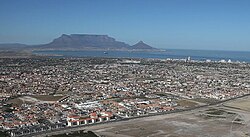
Blouberg or Blaauwberg, is a group of suburbs situated along the Table Bay, approximately 16 kilometres north of Cape Town in the Western Cape, South Africa.