Bleckley County, Georgia | |
|---|---|
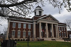 Bleckley County Courthouse in Cochran | |
 Seal | |
 Location within the U.S. state of Georgia | |
| Coordinates: 32°26′N83°20′W / 32.44°N 83.33°W | |
| Country | |
| State | |
| Founded | 1912 |
| Named after | Logan Edwin Bleckley |
| Seat | Cochran |
| Largest city | Cochran |
| Government | |
| • County Commissioner | Mike Davis |
| Area | |
• Total | 219 sq mi (570 km2) |
| • Land | 216 sq mi (560 km2) |
| • Water | 3.3 sq mi (8.5 km2) 1.5% |
| Population (2020) | |
• Total | 12,583 |
| • Density | 58/sq mi (22/km2) |
| Time zone | UTC−5 (Eastern) |
| • Summer (DST) | UTC−4 (EDT) |
| Congressional district | 8th |
| Website | bleckley |
Bleckley County is a county located in the southern portion of the U.S. state of Georgia. As of the 2020 census, the population was 12,583. [1] The county seat is Cochran. [2]

