Dumont, Colorado

Last updated

Dumont, Colorado
Dumont, Colorado.JPG
Dumont looking up towards the Divide, April 2014
Usa edcp location map.svg
Red pog.svg
Dumont
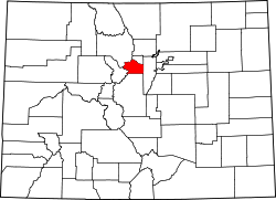
Location of Dumont, Colorado.
USA Colorado location map.svg
Red pog.svg
Dumont
Dumont (Colorado)
Coordinates: 39°45′53″N105°36′01″W / 39.7647°N 105.6003°W / 39.7647; -105.6003 (Dumont, Colorado) [1]
Country United States
State Colorado
County Clear Creek [2]
Government
  Type unincorporated community
  Body Clear Creek County [2]
Elevation
[1]
7,933 ft (2,418 m)
Time zone UTC−07:00 (MST)
  Summer (DST) UTC−06:00 (MDT)
ZIP code [3]
80436
Area codes 303/720/983
GNIS place ID 204707
GNIS CDP ID 2408685
FIPS code 08-21390

Dumont is a small unincorporated community and U.S. Post Office situated along Clear Creek in Clear Creek County, Colorado, United States. The Dumont Post Office has the ZIP Code 80436. [3] Dumont is a part of the Downieville-Lawson-Dumont census-designated place.

Contents

History

The Dumont, Colorado, post office opened on May 17, 1880. [4] Dumont is named for John M. Dumont, a mine operator. [5]

Geography

Downieville is located in the Downieville-Lawson-Dumont, CO Census Designated Place at coordinates 39°45′53″N105°36′01″W / 39.7647°N 105.6003°W / 39.7647; -105.6003 (Dumont, Colorado) and elevation 7,933 feet (2,418 m). [1]

See also

References

  1. 1 2 3 "Dumont, Colorado". Geographic Names Information System . United States Geological Survey, United States Department of the Interior . Retrieved October 16, 2025.
  2. 1 2 "Colorado Counties". Colorado Department of Local Affairs . Retrieved October 16, 2025.
  3. 1 2 "ZIP Code Lookup". United States Postal Service . Retrieved October 16, 2025.
  4. Bauer, William H.; Ozment, James L.; Willard, John H. (1990). Colorado Post Offices 1859–1989. Golden, Colorado: Colorado Railroad Historical Foundation. ISBN   0-918654-42-4.
  5. Gannett, Henry (1905). The Origin of Certain Place Names in the United States. Govt. Print. Off. pp.  110.