Macon County, Georgia

Last updated

Macon County
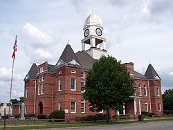
Macon County Courthouse.JPG
Macon County Courthouse in Oglethorpe, Georgia
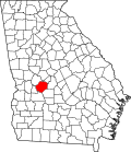
Map of Georgia highlighting Macon County.svg
Location within the U.S. state of Georgia
Georgia in United States.svg
Georgia's location within the U.S.
Coordinates: 32°21′N84°02′W / 32.35°N 84.04°W / 32.35; -84.04
CountryFlag of the United States.svg United States
StateFlag of Georgia (U.S. state).svg  Georgia
FoundedDecember 14, 1837;186 years ago (1837-12-14)
Named for Nathaniel Macon
Seat Oglethorpe
Largest city Montezuma
Area
  Total406 sq mi (1,050 km2)
  Land401 sq mi (1,040 km2)
  Water5.4 sq mi (14 km2)  1.3%
Population
 (2020)
  Total12,082
  Density30/sq mi (10/km2)
Time zone UTC−5 (Eastern)
  Summer (DST) UTC−4 (EDT)
Congressional district 2nd
Website Macon County government

Macon County is a county located in the west central portion of the U.S. state of Georgia. As of the 2020 census, the population was 12,082. [1] The county seat is Oglethorpe. [2] [3]

Contents

The Macon County Courthouse is located in Oglethorpe.

History

Macon County was created in 1837 from parts of Houston ("house-ton") and Marion counties, effective December 14 of that year. The 91st county, it was named for the then-recently deceased General Nathaniel Macon [4] of North Carolina, who served in the U.S. Congress for 37 years and ran for U.S. vice president. The city of Macon, Georgia was also named for him, but the city of Macon, Georgia, is the seat of Bibb County, a different county. The county was later reduced when parts were separated to organize Taylor and Peach counties, in 1852 and 1924, respectively.

The first county seat was not chosen until 1838, when the county's inferior court selected Lanier. The Georgia General Assembly (state legislature) designated it on December 29 of that year and incorporated it as a town.

In the 1850s, the Central of Georgia Railroad was built through Oglethorpe, changing county dynamics. As a result, the Georgia Assembly called for a referendum on moving the Macon County seat to Oglethorpe in February of both 1854 and 1856. Little is known about the first vote, but the second vote resulted in approval for a change to the county seat, and Oglethorpe was designated the following year in 1857.

During the Civil War, 13,000 Union soldiers who were prisoners of war died at the Confederate camp in Andersonville, Georgia from starvation and disease. In the late period of the war, Georgia also had difficulty supplying its own troops and people with food. Throughout the Civil War, more men on both sides died of disease than of their wounds. Commandants of the camp were prosecuted after the war for poor treatment of prisoners. The Andersonville National Cemetery, established for the many Union dead, is at the southwestern tip of the county. [5]

The county has an active Mennonite community. The area code for Macon County is currently 478.

Geography

According to the U.S. Census Bureau, the county has a total area of 406 square miles (1,050 km2), of which 401 square miles (1,040 km2) is land and 5.4 square miles (14 km2) (1.3%) is water. [6] The county is located in the upper Atlantic coastal plain region of the state.

Most of the southern half of Macon County, from west of Ideal to State Route 49 north of Montezuma, then running north along State Route 49 to Marshallville, and then running southeast in the direction of Unadilla, is located in the Middle Flint River sub-basin of the ACF River Basin (Apalachicola-Chattahoochee-Flint River Basin). The northern and northwestern portion of the county, from north of Marshallville heading west, is located in the Upper Flint River sub-basin of the same ACF River Basin. The northeastern corner of Macon County, east of Marshallville, is located in the Lower Ocmulgee River sub-basin of the Altamaha River basin. [7]

Major highways

Adjacent counties

National protected area

Communities

Cities

Demographics

Historical population
CensusPop.Note
1840 5,045
1850 7,05239.8%
1860 8,44919.8%
1870 11,45835.6%
1880 11,6751.9%
1890 13,18312.9%
1900 14,0936.9%
1910 15,0166.5%
1920 17,66717.7%
1930 16,643−5.8%
1940 15,947−4.2%
1950 14,213−10.9%
1960 13,170−7.3%
1970 12,933−1.8%
1980 14,0038.3%
1990 13,114−6.3%
2000 14,0747.3%
2010 14,7404.7%
2020 12,082−18.0%
2023 (est.)11,817 [8] −2.2%
U.S. Decennial Census [9]
1790-1880 [10] 1890-1910 [11]
1920-1930 [12] 1930-1940 [13]
1940-1950 [14] 1960-1980 [15]
1980-2000 [16] 2010 [17] 2020 [18]
Macon County, Georgia – Racial and ethnic composition
Note: the US Census treats Hispanic/Latino as an ethnic category. This table excludes Latinos from the racial categories and assigns them to a separate category. Hispanics/Latinos may be of any race.
Race / Ethnicity (NH = Non-Hispanic)Pop 2000 [19] Pop 2010 [17] Pop 2020 [18] % 2000% 2010% 2020
White alone (NH)5,1844,9614,07836.83%33.66%33.75%
Black or African American alone (NH)8,3378,9027,15059.24%60.39%59.18%
Native American or Alaska Native alone (NH)2619150.18%0.13%0.12%
Asian alone (NH)821901560.58%1.29%1.29%
Pacific Islander alone (NH)01870.00%0.12%0.06%
Other race alone (NH)95200.06%0.03%0.17%
Mixed race or Multiracial (NH)721181840.51%0.80%1.52%
Hispanic or Latino (any race)3645274722.59%3.58%3.91%
Total14,07414,74012,082100.00%100.00%100.00%

As of the 2020 United States census, there were 12,082 people, 4,696 households, and 3,033 families residing in the county.

Education

Politics

United States presidential election results for Macon County, Georgia [20]
Year Republican Democratic Third party
No.%No.%No.%
2020 1,78338.24%2,85861.29%220.47%
2016 1,54035.92%2,70563.10%420.98%
2012 1,54532.28%3,21167.09%300.63%
2008 1,71234.35%3,25165.23%210.42%
2004 1,85138.72%2,90660.79%230.48%
2000 1,56635.96%2,75763.31%320.73%
1996 1,00626.54%2,61869.06%1674.41%
1992 94424.80%2,49165.45%3719.75%
1988 1,41238.19%2,26861.35%170.46%
1984 1,51537.54%2,52162.46%00.00%
1980 89422.47%3,02576.02%601.51%
1976 63817.47%3,01382.53%00.00%
1972 2,00570.55%83729.45%00.00%
1968 59819.22%95430.67%1,55950.11%
1964 1,72361.56%1,07638.44%00.00%
1960 43822.74%1,48877.26%00.00%
1956 36315.47%1,98484.53%00.00%
1952 31917.81%1,47282.19%00.00%
1948 12710.74%67557.11%38032.15%
1944 16815.89%88984.11%00.00%
1940 727.76%85291.81%40.43%
1936 928.74%95890.98%30.28%
1932 553.67%1,43896.06%40.27%
1928 25823.96%81976.04%00.00%
1924 526.93%64986.53%496.53%
1920 6812.34%48387.66%00.00%
1916 9717.38%44078.85%213.76%
1912 8516.50%41179.81%193.69%

Macon County has been an important setting for season 4 of AMC's hit TV show, The Walking Dead.
Macon County was a shooting place for the 2013 movie, The Hunger Games: Catching Fire.

The Mountain Goats reference Macon County, Georgia in their song, "Going to Georgia".

See also

Related Research Articles

<span class="mw-page-title-main">Clay County, Georgia</span> County in Georgia, United States

Clay County is a county located in the southwestern part of the U.S. state of Georgia. As of the 2020 census, the population was 2,848, making it the fourth-least populous county in Georgia. The county seat is Fort Gaines.

<span class="mw-page-title-main">Taliaferro County, Georgia</span> County in Georgia, United States

Taliaferro County is a county located in East central Piedmont region of the U.S. state of Georgia. As of the 2020 census, the population was 1,559, down from the 2010 census when the population was 1,717, making it the least populous county in Georgia and the second least populous county east of the Mississippi River. The county seat is Crawfordville.

<span class="mw-page-title-main">Talbot County, Georgia</span> County in Georgia, United States

Talbot County is a county located in the west central portion of the U.S. state of Georgia. The 2020 census showed a population of 5,733. The county seat and largest city is Talbotton.

<span class="mw-page-title-main">Sumter County, Georgia</span> County in Georgia, United States

Sumter County is a county located in the west-central portion of the U.S. state of Georgia. As of the 2020 census, its population was 29,616. The county seat is Americus. The county was created on December 26, 1831.

<span class="mw-page-title-main">Stewart County, Georgia</span> County in Georgia, United States

Stewart County is a county located in the west central portion of the U.S. state of Georgia. As of the 2020 census, the population was 5,314. The county seat is Lumpkin. The county was created on December 23, 1830.

<span class="mw-page-title-main">Seminole County, Georgia</span> County in Georgia, United States

Seminole County is a county located in the southwestern corner of U.S. state of Georgia. As of the 2020 census, the population was 9,147. The county seat is Donalsonville.

<span class="mw-page-title-main">Schley County, Georgia</span> County in Georgia, United States

Schley County is a county located in the west-central portion of the U.S. state of Georgia. As of the 2020 U.S. census, its population was 4,547. The county seat is Ellaville.

<span class="mw-page-title-main">Randolph County, Georgia</span> County in Georgia, United States

Randolph County is a county located in the southwestern portion of the U.S. state of Georgia and is considered part of the Black Belt, historically an area of plantations. As of the 2020 census, the population was 6,425, roughly one-third of its peak population in 1910, when there were numerous agricultural workers. The county seat is Cuthbert.

<span class="mw-page-title-main">Peach County, Georgia</span> County in Georgia, United States

Peach County is a county located in the central portion of the U.S. state of Georgia. As of the 2020 census, the population was 27,981. Its county seat is Fort Valley. Founded in 1924, it is the state's newest county, taken from Houston and Macon counties on July 18 of that year. Its namesake is the peach on account of it being located in a peach-growing district.

<span class="mw-page-title-main">Monroe County, Georgia</span> County in Georgia, United States

Monroe County is a county located in the central portion of the U.S. state of Georgia. As of the 2020 census, the population was 27,957. The county seat is Forsyth. The county was created on May 15, 1821. The county was named for James Monroe. Monroe County is included in the Macon, GA metropolitan statistical area.

<span class="mw-page-title-main">Mitchell County, Georgia</span> County in Georgia, United States

Mitchell County is a county in the U.S. state of Georgia. As of the 2020 census, the population was 21,755. The county seat is Camilla. Mitchell County was created on December 21, 1857.

<span class="mw-page-title-main">Miller County, Georgia</span> County in Georgia, United States

Miller County is a county located in the southwestern part of the U.S. state of Georgia. As of the 2020 census, the population was 6,000. The county seat is Colquitt. The county was created on February 26, 1856, and named after Andrew Jackson Miller (1806–56), president of the Medical College of Georgia.

<span class="mw-page-title-main">Lamar County, Georgia</span> County in Georgia, United States

Lamar County is a county located in the west central portion of the U.S. state of Georgia. As of the 2020 census, the population was 18,500. The county seat is Barnesville.

<span class="mw-page-title-main">Dougherty County, Georgia</span> County in Georgia, United States

Dougherty County is located in the southwestern portion of the U.S. state of Georgia. As of the 2020 census, the population was 85,790. The county seat and sole incorporated city is Albany.

<span class="mw-page-title-main">Dooly County, Georgia</span> County in Georgia, United States

Dooly County is a county located in the central portion of the U.S. state of Georgia. As of the 2020 census, the population was 11,208. The county seat is Vienna. The county was created by an act of the Georgia General Assembly on May 15, 1821, and named for Colonel John Dooly, a Georgia American Revolutionary War fighter. It was one of the original landlot counties created from land ceded from the Creek Nation.

<span class="mw-page-title-main">Carroll County, Georgia</span> County in Georgia, United States

Carroll County is a county located in the northwestern part of the State of Georgia. As of the 2020 census, its population was 119,148. Its county seat is the city of Carrollton. Carroll County is included in the Atlanta-Sandy Springs-Roswell metropolitan statistical area and is also adjacent to Alabama on its western border.

<span class="mw-page-title-main">Brantley County, Georgia</span> County in Georgia, United States

Brantley County is a county located in the southeastern part of the U.S. state of Georgia. As of the 2020 census, the population was 18,021. The county seat is Nahunta. Brantley County is part of the Brunswick, Georgia metropolitan statistical area.

<span class="mw-page-title-main">Baker County, Georgia</span> County in Georgia, United States

Baker County is a county in Georgia. As of the 2020 census, the population was 2,876. The county seat and only city is Newton. The county was created December 12, 1825, from the eastern portion of Early County by an act of the Georgia General Assembly and is named for Colonel John Baker, a hero of the American Revolutionary War.

<span class="mw-page-title-main">Montezuma, Georgia</span> City in Georgia, United States

Montezuma is a city in Macon County, Georgia. The population was 3,047 at the 2020 census, down from 3,460 in 2010. It is home to the armory of Bravo Company, 648th Engineers of the Georgia Army National Guard.

<span class="mw-page-title-main">Oglethorpe, Georgia</span> City in Georgia, United States

Oglethorpe is a city in Macon County, Georgia, United States. The population was 995 at the 2020 census, down from 1,328 in 2010. The city is the county seat of Macon County. It was named for Georgia's founder, James Oglethorpe.

References

  1. "Census - Geography Profile: Macon County, Georgia". United States Census Bureau . Retrieved December 27, 2022.
  2. "Find a County". National Association of Counties. Retrieved June 7, 2011.
  3. "Macon County Courthouse". Archived from the original on October 12, 2000. Retrieved August 7, 2005.
  4. Gannett, Henry (1905). The Origin of Certain Place Names in the United States. U.S. Government Printing Office. p.  195.
  5. "Macon County". Georgia.gov. Archived from the original on October 12, 2008. Retrieved August 8, 2018.
  6. "US Gazetteer files: 2010, 2000, and 1990". United States Census Bureau. February 12, 2011. Retrieved April 23, 2011.
  7. "Georgia Soil and Water Conservation Commission Interactive Mapping Experience". Georgia Soil and Water Conservation Commission. Retrieved November 24, 2015.
  8. "Annual Estimates of the Resident Population for Counties: April 1, 2020 to July 1, 2023". United States Census Bureau. Retrieved March 31, 2024.
  9. "Decennial Census of Population and Housing by Decades". United States Census Bureau.
  10. "1880 Census Population by Counties 1790-1800" (PDF). United States Census Bureau. 1880.
  11. "1910 Census of Population - Georgia" (PDF). United States Census Bureau. 1910.
  12. "1930 Census of Population - Georgia" (PDF). United States Census Bureau. 1930.
  13. "1940 Census of Population - Georgia" (PDF). United States Census Bureau. 1940.
  14. "1950 Census of Population - Georgia -" (PDF). United States Census Bureau. 1950.
  15. "1980 Census of Population - Number of Inhabitants - Georgia" (PDF). United States Census Bureau. 1980.
  16. "2000 Census of Population - Population and Housing Unit Counts - Georgia" (PDF). United States Census Bureau. 2000.
  17. 1 2 "P2: Hispanic or Latino, and Not Hispanic or Latino by Race – 2010: DEC Redistricting Data (PL 94-171) – Macon County, Georgia". United States Census Bureau. Retrieved January 26, 2024.
  18. 1 2 "P2: Hispanic or Latino, and Not Hispanic or Latino by Race – 2020: DEC Redistricting Data (PL 94-171) – Macon County, Georgia". United States Census Bureau. Retrieved January 26, 2024.
  19. "P004: Hispanic or Latino, and Not Hispanic or Latino by Race – 2000: DEC Summary File 1 – Macon County, Georgia". United States Census Bureau. Retrieved January 26, 2024.
  20. Leip, David. "Dave Leip's Atlas of U.S. Presidential Elections". uselectionatlas.org. Retrieved March 21, 2018.

32°21′N84°02′W / 32.35°N 84.04°W / 32.35; -84.04