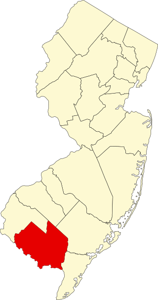
[3] Name on the Register [4] Image Date listed [5] Location City or town Description 1 Academy Building Academy Building January 18, 1973 (# 73000111 Gorham campus of the University of Southern Maine 43°40′55″N 70°26′45″W / 43.681944°N 70.445833°W / 43.681944; -70.445833 (Academy Building ) Gorham 2 Lt. Robert Andrews House Lt. Robert Andrews House December 21, 2005 (# 05001440 428 S. Bridgton Rd. 43°59′42″N 70°42′27″W / 43.995°N 70.7075°W / 43.995; -70.7075 (Lt. Robert Andrews House ) Bridgton 3 Androscoggin Swinging Bridge Androscoggin Swinging Bridge January 14, 2004 (# 03001404 Spanning the Androscoggin River between Topsham and Brunswick 43°55′06″N 69°58′26″W / 43.918333°N 69.973889°W / 43.918333; -69.973889 (Androscoggin Swinging Bridge ) Brunswick 4 Art Gallery Art Gallery December 27, 1972 (# 72000071 Gorham campus of the University of Southern Maine at Gorham 43°40′47″N 70°26′53″W / 43.679722°N 70.448056°W / 43.679722; -70.448056 (Art Gallery ) Gorham 5 Auburn-Harpswell Association Historic District Auburn-Harpswell Association Historic District March 21, 1985 (# 85000615 State Route 123 43°44′47″N 70°00′46″W / 43.746389°N 70.012778°W / 43.746389; -70.012778 (Auburn-Harpswell Association Historic District ) Harpswell 6 Bailey Island Cobwork Bridge Bailey Island Cobwork Bridge April 28, 1975 (# 75000093 On State Route 24 connecting Bailey and Orrs islands 43°44′55″N 69°59′22″W / 43.748611°N 69.989444°W / 43.748611; -69.989444 (Bailey Island Cobwork Bridge ) Harpswell 7 Bailey Island Library Hall Bailey Island Library Hall December 31, 2008 (# 08001253 2167 Harpswell Island Rd. 43°43′57″N 69°59′43″W / 43.7325°N 69.9953°W / 43.7325; -69.9953 (Bailey Island Library Hall ) Harpswell 8 Baxter House Baxter House June 27, 1979 (# 79000135 South St. 43°40′37″N 70°26′34″W / 43.676944°N 70.442778°W / 43.676944; -70.442778 (Baxter House ) Gorham 9 Baxter Summer Home Baxter Summer Home December 26, 1985 (# 85003155 Mackworth Island 43°41′17″N 70°13′59″W / 43.688056°N 70.233056°W / 43.688056; -70.233056 (Baxter Summer Home ) Falmouth 10 Beckett's Castle Upload image December 31, 1974 (# 74000156 Off State Route 77 43°36′55″N 70°12′42″W / 43.615278°N 70.211667°W / 43.615278; -70.211667 (Beckett's Castle ) Cape Elizabeth 11 Capt. S.C. Blanchard House Capt. S.C. Blanchard House May 7, 1979 (# 79000136 317 Main St. 43°48′09″N 70°11′29″W / 43.8025°N 70.191389°W / 43.8025; -70.191389 (Capt. S.C. Blanchard House ) Yarmouth Houses the 317 Main Community Music Center 12 Henry Boody House Henry Boody House February 24, 1975 (# 75000094 256 Maine St. 43°54′25″N 69°57′57″W / 43.906944°N 69.965833°W / 43.906944; -69.965833 (Henry Boody House ) Brunswick Owned by Bowdoin College. 13 C.A. Brown Cottage C.A. Brown Cottage July 30, 1974 (# 74000157 9 Delano Park 43°37′11″N 70°12′40″W / 43.619722°N 70.211111°W / 43.619722; -70.211111 (C.A. Brown Cottage ) Cape Elizabeth 14 Brunswick Commercial Historic District Brunswick Commercial Historic District January 12, 2016 (# 15000968 50-151 Maine St. 43°54′57″N 69°57′56″W / 43.915767°N 69.965564°W / 43.915767; -69.965564 (Brunswick Commercial Historic District ) Brunswick 15 Burnell Tavern Burnell Tavern December 29, 1983 (# 83003638 State Route 113 43°50′01″N 70°46′46″W / 43.833611°N 70.779444°W / 43.833611; -70.779444 (Burnell Tavern ) Baldwin 16 Camp Hammond Camp Hammond February 1, 1979 (# 79000137 74 Main St. 43°48′10″N 70°11′23″W / 43.802778°N 70.189722°W / 43.802778; -70.189722 (Camp Hammond ) Yarmouth 17 Caswell Public Library (Former) Caswell Public Library (Former) February 15, 2005 (# 05000056 42 Main St. 44°06′39″N 70°40′50″W / 44.110833°N 70.680556°W / 44.110833; -70.680556 (Caswell Public Library (Former) ) Harrison 18 Central Parish Church Central Parish Church June 23, 1988 (# 88000892 146 Main St. 43°47′57″N 70°10′58″W / 43.799167°N 70.182778°W / 43.799167; -70.182778 (Central Parish Church ) Yarmouth 19 Parker Cleaveland House Parker Cleaveland House May 16, 2000 (# 00000702 75 Federal St. 43°54′38″N 69°57′36″W / 43.910556°N 69.96°W / 43.910556; -69.96 (Parker Cleaveland House ) Brunswick 20 Benjamin Cleaves House Benjamin Cleaves House April 20, 1988 (# 88000390 S. High St. 44°02′23″N 70°42′39″W / 44.039722°N 70.710833°W / 44.039722; -70.710833 (Benjamin Cleaves House ) Bridgton 21 Cousins Island Chapel Cousins Island Chapel June 20, 1997 (# 97000605 Eastern side of Cousins Rd., 1.9 miles southeast of its junction with Morton Rd. 43°45′39″N 70°08′30″W / 43.760833°N 70.141667°W / 43.760833; -70.141667 (Cousins Island Chapel ) Yarmouth 22 Crescent Lodge Crescent Lodge June 19, 2018 (# 100002591 1 Wheeler Rd. 43°34′20″N 70°13′14″W / 43.5721°N 70.2205°W / 43.5721; -70.2205 (Crescent Lodge ) Cape Elizabeth AKA the Bowery Beach School 23 Crystal Spring Farm Crystal Spring Farm April 29, 2004 (# 04000369 277 Pleasant Hill Rd. 43°53′24″N 69°59′49″W / 43.89°N 69.996944°W / 43.89; -69.996944 (Crystal Spring Farm ) Brunswick 24 Cumberland and Oxford Canal Cumberland and Oxford Canal November 1, 1974 (# 74000317 From Sebago Lake Basin to Conant St. 43°45′05″N 70°25′47″W / 43.751389°N 70.429722°W / 43.751389; -70.429722 (Cumberland and Oxford Canal ) Gorham , Standish , Westbrook , and Windham 25 Cumberland Mills Historic District Cumberland Mills Historic District May 2, 1974 (# 74000316 Both sides of the Presumpscot River between railroad tracks and Warren Ave. 43°40′57″N 70°21′10″W / 43.6825°N 70.352778°W / 43.6825; -70.352778 (Cumberland Mills Historic District ) Westbrook 26 Dalton Holmes Davis Memorial Library Dalton Holmes Davis Memorial Library January 5, 1989 (# 88003020 Main St. 44°03′15″N 70°42′37″W / 44.054167°N 70.710278°W / 44.054167; -70.710278 (Dalton Holmes Davis Memorial Library ) Bridgton 27 Deertrees Theatre Deertrees Theatre January 5, 1989 (# 88003002 Deertrees Rd. 44°07′03″N 70°39′54″W / 44.1175°N 70.665°W / 44.1175; -70.665 (Deertrees Theatre ) Harrison 28 Dow Bridge Upload image June 14, 2022 (# 100007807 Dow Rd. at Josie's Brook, 1/3 mi. northwest of Cape Rd. 43°43′23″N 70°35′38″W / 43.7231°N 70.5940°W / 43.7231; -70.5940 (Dow Bridge ) Standish 29 Dry Mills School Dry Mills School December 13, 1996 (# 96001495 Maine Wildlife Park Rd. 43°55′42″N 70°21′00″W / 43.9282°N 70.3499°W / 43.9282; -70.3499 (Dry Mills School ) Gray 30 John Dunlap House John Dunlap House June 14, 1979 (# 79000138 4 Oak St. 43°55′02″N 69°58′08″W / 43.917222°N 69.968889°W / 43.917222; -69.968889 (John Dunlap House ) Brunswick 31 Deacon Andrew Dunning House Deacon Andrew Dunning House October 8, 1999 (# 99001188 Mountain Rd., 0.6 miles southeast of its junction with State Route 123 43°49′01″N 69°57′23″W / 43.8169°N 69.9563°W / 43.8169; -69.9563 (Deacon Andrew Dunning House ) Harpswell 32 Dunstan Methodist Episcopal Church Dunstan Methodist Episcopal Church July 13, 1989 (# 89000839 U.S. Route 1 43°34′02″N 70°23′27″W / 43.567222°N 70.390833°W / 43.567222; -70.390833 (Dunstan Methodist Episcopal Church ) Scarborough 33 Isaac W. Dyer Estate Isaac W. Dyer Estate April 1, 1998 (# 98000307 180 Fort Hill Rd. 43°41′18″N 70°26′56″W / 43.688333°N 70.448889°W / 43.688333; -70.448889 (Isaac W. Dyer Estate ) Gorham Misspelled "Isaac E. Dyer Estate" in the National Register 34 Dyer-Hutchinson Farm Dyer-Hutchinson Farm April 14, 1997 (# 97000313 1148 Sawyer Rd. 43°36′18″N 70°15′48″W / 43.605°N 70.263333°W / 43.605; -70.263333 (Dyer-Hutchinson Farm ) Cape Elizabeth 35 Dyke Mountain Annex Dyke Mountain Annex February 15, 2005 (# 05000059 319 Dyke Mountain Rd. 43°52′19″N 70°42′37″W / 43.871944°N 70.710278°W / 43.871944; -70.710278 (Dyke Mountain Annex ) Sebago 36 Eagle Island Eagle Island November 23, 1971 (# 71000069 South of Harpswell on Eagle Island 43°42′41″N 70°03′23″W / 43.711389°N 70.056389°W / 43.711389; -70.056389 (Eagle Island ) Harpswell 37 East Harpswell Free Will Baptist Church East Harpswell Free Will Baptist Church June 23, 1988 (# 88000888 Cundys Harbor Rd. 43°50′03″N 69°53′56″W / 43.8341°N 69.8989°W / 43.8341; -69.8989 (East Harpswell Free Will Baptist Church ) Harpswell 38 East Raymond Union Chapel East Raymond Union Chapel April 28, 2004 (# 04000370 394 Webbs Mills Rd. 43°56′02″N 70°26′29″W / 43.933889°N 70.441389°W / 43.933889; -70.441389 (East Raymond Union Chapel ) Raymond 39 Falmouth High School Falmouth High School January 12, 2016 (# 15000967 192 Middle Rd. 43°43′26″N 70°14′42″W / 43.723896°N 70.244987°W / 43.723896; -70.244987 (Falmouth High School ) Falmouth Most recently known as the Plummer-Motz School 40 Falmouth House Falmouth House September 1, 1976 (# 76000091 349 Gray Rd. 43°46′21″N 70°18′04″W / 43.7725°N 70.301111°W / 43.7725; -70.301111 (Falmouth House ) Falmouth 41 Farnsworth House Upload image November 14, 1980 (# 80000229 State Route 117 44°05′30″N 70°41′56″W / 44.091604°N 70.698862°W / 44.091604; -70.698862 (Farnsworth House ) Bridgton 42 Federal Street Historic District Federal Street Historic District October 29, 1976 (# 76000092 Roughly bounded by Mason, Maine, College, and Federal Sts. 43°54′45″N 69°57′45″W / 43.9125°N 69.9625°W / 43.9125; -69.9625 (Federal Street Historic District ) Brunswick 43 First Parish Church First Parish Church December 2, 1969 (# 69000008 207 Maine St. 43°54′38″N 69°57′47″W / 43.910556°N 69.963056°W / 43.910556; -69.963056 (First Parish Church ) Brunswick 44 First Parish Congregational Church First Parish Congregational Church June 20, 1995 (# 95000728 135 Main St. 43°47′55″N 70°11′04″W / 43.798611°N 70.184444°W / 43.798611; -70.184444 (First Parish Congregational Church ) Yarmouth 45 First Parish Meetinghouse First Parish Meetinghouse March 27, 1975 (# 75000204 Oak Hill Rd. 43°44′17″N 70°33′21″W / 43.738056°N 70.555833°W / 43.738056; -70.555833 (First Parish Meetinghouse ) Standish 46 Fitch's General Store and House Fitch's General Store and House March 10, 1995 (# 95000215 Eastern side of Long Hill Rd. at its junction with State Route 114 43°51′26″N 70°38′32″W / 43.857222°N 70.642222°W / 43.857222; -70.642222 (Fitch's General Store and House ) Sebago 47 Freeman Farm Historic District Freeman Farm Historic District July 10, 2003 (# 03000621 342 W. Gray Rd. 43°51′18″N 70°23′08″W / 43.855°N 70.385556°W / 43.855; -70.385556 (Freeman Farm Historic District ) Gray 48 Freeport Main Street Historic District Freeport Main Street Historic District November 16, 1977 (# 77000064 Main St. 43°51′22″N 70°06′19″W / 43.856111°N 70.105278°W / 43.856111; -70.105278 (Freeport Main Street Historic District ) Freeport Main Street (US 1) between Holbrook and Nathan Nye Streets. 49 Friends Meetinghouse Friends Meetinghouse September 9, 1975 (# 75000095 Quaker Ridge 43°58′12″N 70°31′56″W / 43.97°N 70.532222°W / 43.97; -70.532222 (Friends Meetinghouse ) Casco 50 Goold House Goold House August 10, 1990 (# 89000251 280 Windham Center Rd. 43°47′11″N 70°24′09″W / 43.786389°N 70.4025°W / 43.786389; -70.4025 (Goold House ) Windham 51 Gorham Campus Historic District Gorham Campus Historic District May 5, 1978 (# 78000171 College Ave. 43°40′51″N 70°26′47″W / 43.680833°N 70.446389°W / 43.680833; -70.446389 (Gorham Campus Historic District ) Gorham 52 Gorham Historic District Gorham Historic District October 2, 1992 (# 92001298 Roughly bounded by College, Church, Cross, State, and Maple Sts., including School St. from State to north of Church 43°40′46″N 70°26′44″W / 43.679444°N 70.445556°W / 43.679444; -70.445556 (Gorham Historic District ) Gorham 53 Grand Trunk Railroad Station Grand Trunk Railroad Station July 10, 1979 (# 79000139 State Route 115 43°48′06″N 70°11′28″W / 43.801667°N 70.191111°W / 43.801667; -70.191111 (Grand Trunk Railroad Station ) Yarmouth 54 Great Chebeague Golf Club Upload image July 14, 2015 (# 15000416 16 Stone Wharf Rd. 43°45′07″N 70°06′18″W / 43.7520°N 70.105°W / 43.7520; -70.105 (Great Chebeague Golf Club ) Chebeague Island 55 Great Falls Historic District Great Falls Historic District January 12, 1995 (# 94001541 Along Windham Center Rd., east of the Presumpscot River 43°48′09″N 70°26′49″W / 43.8025°N 70.446944°W / 43.8025; -70.446944 (Great Falls Historic District ) Windham 56 Greene Cottage Upload image September 30, 2019 (# 100004472 516 Basin Point Rd. 43°44′22″N 70°02′29″W / 43.7395°N 70.0415°W / 43.7395; -70.0415 (Greene Cottage ) Harpswell 57 Halfway Rock Light Station Halfway Rock Light Station March 14, 1988 (# 88000150 Casco Bay off Bailey Island 43°39′21″N 70°02′14″W / 43.655833°N 70.037222°W / 43.655833; -70.037222 (Halfway Rock Light Station ) Harpswell 58 Hall's Tavern Hall's Tavern March 30, 1978 (# 78000172 West of Falmouth at 377 Gray Rd. 43°46′38″N 70°18′09″W / 43.777222°N 70.3025°W / 43.777222; -70.3025 (Hall's Tavern ) Falmouth 59 Harpswell Meetinghouse Harpswell Meetinghouse November 24, 1968 (# 68000014 Harpswell Center on State Route 123 , 9 miles south of Brunswick 43°47′56″N 69°59′15″W / 43.798889°N 69.9875°W / 43.798889; -69.9875 (Harpswell Meetinghouse ) Harpswell 60 Harraseeket Historic District Harraseeket Historic District June 28, 1974 (# 74000160 Roughly both sides of the Harraseeket River , including South Freeport, Porters Landing, and Mast Landing 43°49′36″N 70°05′40″W / 43.826667°N 70.094444°W / 43.826667; -70.094444 (Harraseeket Historic District ) Freeport 61 Nathan Harris House Nathan Harris House October 14, 1993 (# 93001116 425 Main St. 43°40′53″N 70°20′55″W / 43.681389°N 70.348611°W / 43.681389; -70.348611 (Nathan Harris House ) Westbrook 62 Nathaniel Hawthorne Boyhood Home Nathaniel Hawthorne Boyhood Home December 2, 1969 (# 69000030 Hawthorne and Raymond Cape Rds. 43°54′22″N 70°30′47″W / 43.906111°N 70.513056°W / 43.906111; -70.513056 (Nathaniel Hawthorne Boyhood Home ) Raymond 63 Winslow Homer Studio Winslow Homer Studio October 15, 1966 (# 66000092 Winslow Homer Rd., Prouts Neck 43°31′42″N 70°19′13″W / 43.528333°N 70.320278°W / 43.528333; -70.320278 (Winslow Homer Studio ) Scarborough 64 Richard Hunniwell House Richard Hunniwell House May 12, 1976 (# 76000093 West of Scarborough at Winnock's Neck and Old County Rds. 43°34′50″N 70°19′55″W / 43.580556°N 70.331944°W / 43.580556; -70.331944 (Richard Hunniwell House ) Scarborough 65 Intervale Farm Intervale Farm January 14, 2004 (# 03001407 1047 Intervale Rd. 43°55′39″N 70°15′06″W / 43.9275°N 70.251667°W / 43.9275; -70.251667 (Intervale Farm ) New Gloucester 66 Elijah Kellogg Church Elijah Kellogg Church June 27, 1979 (# 79000140 State Route 123 43°47′59″N 69°59′12″W / 43.799722°N 69.986667°W / 43.799722; -69.986667 (Elijah Kellogg Church ) Harpswell 67 Elijah Kellogg House Elijah Kellogg House April 28, 1975 (# 75000096 North of North Harpswell off State Route 123 43°50′06″N 69°58′03″W / 43.835°N 69.9675°W / 43.835; -69.9675 (Elijah Kellogg House ) Harpswell 68 Lakeside Grange #63 Lakeside Grange #63 October 19, 2005 (# 05001173 Main St. at its junction with Lincoln St. 44°06′37″N 70°40′54″W / 44.110278°N 70.681667°W / 44.110278; -70.681667 (Lakeside Grange #63 ) Harrison 69 Lincoln Street Historic District Lincoln Street Historic District December 12, 1976 (# 76000094 Lincoln St. between Main and Union Sts. 43°55′00″N 69°58′03″W / 43.916667°N 69.9675°W / 43.916667; -69.9675 (Lincoln Street Historic District ) Brunswick 70 Little Mark Island Monument Upload image June 7, 2016 (# 16000338 N. Casco Bay at mouth of Merriconeag Sound 43°42′33″N 70°01′53″W / 43.709135°N 70.031352°W / 43.709135; -70.031352 (Little Mark Island Monument ) Harpswell 71 Stephen Longfellow House Stephen Longfellow House March 22, 1984 (# 84001365 Longfellow Rd. 43°40′07″N 70°23′54″W / 43.668611°N 70.398333°W / 43.668611; -70.398333 (Stephen Longfellow House ) Gorham 72 Mallett Hall Mallett Hall October 16, 1991 (# 91001511 Eastern side of State Route 9 north of Dyer Rd. 43°53′34″N 70°11′03″W / 43.892778°N 70.184167°W / 43.892778; -70.184167 (Mallett Hall ) Pownal Center Pownal's town hall 73 E.B. Mallett Office Building E.B. Mallett Office Building February 19, 1982 (# 82000747 Mill St. 43°51′22″N 70°06′13″W / 43.856111°N 70.103611°W / 43.856111; -70.103611 (E.B. Mallett Office Building ) Freeport 74 Richard Manning House Richard Manning House July 29, 1993 (# 93000639 Western side of Raymond Cape Rd. 0.3 miles south of U.S. Route 302 43°54′33″N 70°30′53″W / 43.909167°N 70.514722°W / 43.909167; -70.514722 (Richard Manning House ) Casco 75 Manor House Manor House July 12, 1978 (# 78000173 U.S. Route 302 43°58′47″N 70°37′37″W / 43.979767°N 70.626869°W / 43.979767; -70.626869 (Manor House ) Naples 76 Maplewood Farm Maplewood Farm December 13, 1991 (# 91001813 River Rd. southeast of its junction with Webber Rd. 43°42′47″N 70°23′34″W / 43.713056°N 70.392778°W / 43.713056; -70.392778 (Maplewood Farm ) Windham 77 Daniel Marrett House Daniel Marrett House February 15, 1974 (# 74000314 On State Route 25 43°43′55″N 70°33′05″W / 43.731944°N 70.551389°W / 43.731944; -70.551389 (Daniel Marrett House ) Standish 78 Massachusetts Hall, Bowdoin College Massachusetts Hall, Bowdoin College July 27, 1971 (# 71000042 Bowdoin College campus 43°54′35″N 69°57′44″W / 43.909722°N 69.962222°W / 43.909722; -69.962222 (Massachusetts Hall, Bowdoin College ) Brunswick 79 McLellan House McLellan House December 5, 1972 (# 72000073 140 School St. 43°41′06″N 70°26′49″W / 43.685°N 70.446944°W / 43.685; -70.446944 (McLellan House ) Gorham 80 Merriconeag Grange No. 425 Merriconeag Grange No. 425 May 31, 2019 (# 100004068 529 Harpswell Neck Rd. 43°49′19″N 69°57′54″W / 43.8220°N 69.9651°W / 43.8220; -69.9651 (Merriconeag Grange No. 425 ) Harpswell 81 Merriconegan Farm Merriconegan Farm June 15, 1979 (# 79000269 State Route 123 43°51′16″N 69°56′58″W / 43.854444°N 69.949444°W / 43.854444; -69.949444 (Merriconegan Farm ) Harpswell 82 Capt. Reuben Merrill House Capt. Reuben Merrill House July 12, 1974 (# 74000313 233 W. Main St. 43°48′14″N 70°12′15″W / 43.803834°N 70.204121°W / 43.803834; -70.204121 (Capt. Reuben Merrill House ) Yarmouth 83 Capt. Reuel and Lucy Merrill House Capt. Reuel and Lucy Merrill House April 14, 1999 (# 99000378 66 Winn Rd. 43°46′46″N 70°15′34″W / 43.779497°N 70.259424°W / 43.779497; -70.259424 (Capt. Reuel and Lucy Merrill House ) Cumberland Center 84 Mitchell House Mitchell House January 20, 1978 (# 78000325 333 Main St. 43°48′11″N 70°11′32″W / 43.803056°N 70.192222°W / 43.803056; -70.192222 (Mitchell House ) Yarmouth 85 New Gloucester Historic District New Gloucester Historic District November 13, 1974 (# 74000162 Both sides of SR 231 , Gloucester Hill Rd., Cobbs Bridge Rd. 43°57′41″N 70°16′58″W / 43.961389°N 70.282778°W / 43.961389; -70.282778 (New Gloucester Historic District ) New Gloucester 86 North Yarmouth Academy North Yarmouth Academy March 4, 1975 (# 75000097 On State Route 115 43°48′00″N 70°11′04″W / 43.8°N 70.184444°W / 43.8; -70.184444 (North Yarmouth Academy ) Yarmouth Russell Hall and Academy Hall on the NYA campus 87 North Yarmouth and Freeport Baptist Meetinghouse North Yarmouth and Freeport Baptist Meetinghouse November 20, 1978 (# 78000174 Hillside St. 43°48′13″N 70°11′46″W / 43.803611°N 70.196111°W / 43.803611; -70.196111 (North Yarmouth and Freeport Baptist Meetinghouse ) Yarmouth 88 Norton House Historic District Norton House Historic District January 28, 2004 (# 03001501 241 and 243 Foreside Rd. 43°43′54″N 70°12′36″W / 43.731667°N 70.21°W / 43.731667; -70.21 (Norton House Historic District ) Falmouth 89 Orr's Island Meeting House Upload image September 15, 2022 (# 100008122 1579 Harpswell Islands Rd., Orr's Island 43°46′08″N 69°58′16″W / 43.7688°N 69.9712°W / 43.7688; -69.9712 (Orr's Island Meeting House ) Harpswell 90 Paine Neighborhood Historic District Paine Neighborhood Historic District April 11, 1985 (# 85000731 State Route 113 43°44′27″N 70°36′05″W / 43.740833°N 70.601389°W / 43.740833; -70.601389 (Paine Neighborhood Historic District ) Standish 91 Payson House at Thornhurst Payson House at Thornhurst February 15, 2005 (# 05000057 48 Thornhurst Rd. 43°42′56″N 70°13′07″W / 43.715556°N 70.218611°W / 43.715556; -70.218611 (Payson House at Thornhurst ) Falmouth 92 Peabody-Fitch House Peabody-Fitch House April 7, 1989 (# 89000254 Off Ingalls Rd. 43°58′59″N 70°43′28″W / 43.983056°N 70.724444°W / 43.983056; -70.724444 (Peabody-Fitch House ) Bridgton 93 Pennell Institute Pennell Institute July 12, 1982 (# 82000750 Lewiston Rd. 43°53′16″N 70°19′41″W / 43.887778°N 70.328056°W / 43.887778; -70.328056 (Pennell Institute ) Gray Now houses town offices 94 Pennellville Historic District Pennellville Historic District October 10, 1985 (# 85002923 Roughly bounded by Pennellville Rd., Middle Bay Cove, and Pennell Way 43°51′42″N 69°57′40″W / 43.8617°N 69.9611°W / 43.8617; -69.9611 (Pennellville Historic District ) Brunswick 95 Sam Perley Farm Sam Perley Farm July 10, 1979 (# 79000143 Perley Rd. 43°59′09″N 70°39′47″W / 43.985833°N 70.663056°W / 43.985833; -70.663056 (Sam Perley Farm ) Naples 96 William F. Perry House William F. Perry House September 25, 1975 (# 75000098 32 Main St. 44°03′17″N 70°42′52″W / 44.054722°N 70.714444°W / 44.054722; -70.714444 (William F. Perry House ) Bridgton 97 Pettengill House and Farm Pettengill House and Farm October 6, 1970 (# 70000041 South of Bow St. 43°51′01″N 70°04′55″W / 43.850278°N 70.081944°W / 43.850278; -70.081944 (Pettengill House and Farm ) Freeport 98 Portland Breakwater Light Portland Breakwater Light June 19, 1973 (# 73000238 Northeastern end of the Portland Breakwater in Portland Harbor 43°39′19″N 70°14′07″W / 43.655278°N 70.235278°W / 43.655278; -70.235278 (Portland Breakwater Light ) South Portland 99 Portland Headlight Portland Headlight April 24, 1973 (# 73000121 Portland Head off Shore Rd. 43°37′23″N 70°12′29″W / 43.623056°N 70.208056°W / 43.623056; -70.208056 (Portland Headlight ) Cape Elizabeth 100 Portland Railroad Company Substation Portland Railroad Company Substation March 22, 1991 (# 91000320 U.S. Route 1 43°34′06″N 70°23′31″W / 43.568333°N 70.391944°W / 43.568333; -70.391944 (Portland Railroad Company Substation ) Scarborough 101 Capt. Greenfield Pote House Capt. Greenfield Pote House October 6, 1970 (# 70000042 Wolf Neck Rd. 43°49′49″N 70°04′58″W / 43.830278°N 70.082778°W / 43.830278; -70.082778 (Capt. Greenfield Pote House ) Freeport 102 Pownal Cattle Pound Pownal Cattle Pound July 28, 2004 (# 04000745 Hallowell Rd., Bradbury Mountain State Park , 0.7 miles north of its junction with Dyer Rd. 43°54′06″N 70°10′41″W / 43.901667°N 70.178056°W / 43.901667; -70.178056 (Pownal Cattle Pound ) Pownal 103 Cushing and Hannah Prince House Cushing and Hannah Prince House July 1, 1999 (# 99000772 189 Greely Rd. 43°47′50″N 70°13′25″W / 43.797222°N 70.223611°W / 43.797222; -70.223611 (Cushing and Hannah Prince House ) Yarmouth 104 Proprietors Meeting House and Parish House Proprietors Meeting House and Parish House August 2, 2001 (# 01000813 Junction of State Route 22 and Old County Rd. 43°37′14″N 70°28′45″W / 43.620556°N 70.479167°W / 43.620556; -70.479167 (Proprietors Meeting House and Parish House ) South Buxton (Scarborough side) 105 Elisha Purington House Elisha Purington House February 14, 1985 (# 85000271 71 Mast Rd. 43°45′52″N 70°20′38″W / 43.764444°N 70.343889°W / 43.764444; -70.343889 (Elisha Purington House ) Falmouth 106 Ram Island Ledge Light Station Ram Island Ledge Light Station March 14, 1988 (# 88000157 Ram Island Ledge in Portland Harbor 43°37′53″N 70°11′16″W / 43.631389°N 70.187778°W / 43.631389; -70.187778 (Ram Island Ledge Light Station ) Cape Elizabeth 107 Jacob Randall House Jacob Randall House March 2, 1979 (# 79000144 Lawrence Rd. 43°55′48″N 70°11′32″W / 43.93°N 70.192222°W / 43.93; -70.192222 (Jacob Randall House ) Pownal 108 Richardson House Richardson House May 16, 1974 (# 74000165 11 Lincoln St. 43°54′42″N 69°58′12″W / 43.911667°N 69.97°W / 43.911667; -69.97 (Richardson House ) Brunswick 109 Richmond's Island Archeological Site Richmond's Island Archeological Site November 2, 1978 (# 78000175 most of Richmond Island 43°32′38″N 70°14′05″W / 43.5439°N 70.2347°W / 43.5439; -70.2347 (Richmond's Island Archeological Site ) Cape Elizabeth 110 Ryefield Bridge Ryefield Bridge September 24, 1999 (# 99001193 Ryefield Bridge Road over the Crooked River 44°08′34″N 70°35′43″W / 44.142778°N 70.595278°W / 44.142778; -70.595278 (Ryefield Bridge ) Harrison Extends into Oxford County 111 St. Hyacinth School and Convent St. Hyacinth School and Convent June 25, 2013 (# 13000439 2 Walker Street 43°40′49″N 70°21′55″W / 43.68038°N 70.36522°W / 43.68038; -70.36522 (St. Hyacinth School and Convent ) Westbrook 112 St. Paul's Episcopal Church St. Paul's Episcopal Church January 31, 1978 (# 78000177 27 Pleasant St. 43°54′49″N 69°58′06″W / 43.913611°N 69.968333°W / 43.913611; -69.968333 (St. Paul's Episcopal Church ) Brunswick 113 Scarborough High School Scarborough High School June 27, 2007 (# 07000595 272 U.S. Route 1 43°35′19″N 70°20′28″W / 43.588611°N 70.341111°W / 43.588611; -70.341111 (Scarborough High School ) Scarborough 114 Scribner Homestead Scribner Homestead April 12, 2001 (# 01000368 244 Scribner's Mill Rd. 44°05′10″N 70°36′22″W / 44.086111°N 70.606111°W / 44.086111; -70.606111 (Scribner Homestead ) Harrison 115 Seavey-Robinson House Seavey-Robinson House September 11, 1986 (# 86002468 580 Ocean St. 43°37′22″N 70°14′57″W / 43.6227°N 70.2491°W / 43.6227; -70.2491 (Seavey-Robinson House ) South Portland 116 Shaker Village Shaker Village September 13, 1974 (# 74000318 State Route 26 43°59′22″N 70°21′59″W / 43.989444°N 70.366389°W / 43.989444; -70.366389 (Shaker Village ) New Gloucester Extends into Androscoggin County 117 Thomas Skelton House Thomas Skelton House May 7, 1973 (# 73000124 124 U.S. Route 1 43°42′28″N 70°14′14″W / 43.707778°N 70.237222°W / 43.707778; -70.237222 (Thomas Skelton House ) Falmouth 118 Parson Smith House Parson Smith House July 16, 1973 (# 73000237 Southeast of South Windham on River Rd. 43°42′58″N 70°23′33″W / 43.716111°N 70.3925°W / 43.716111; -70.3925 (Parson Smith House ) Windham 119 Songo Lock Songo Lock February 16, 1970 (# 70000093 South of Naples off State Route 114 43°55′55″N 70°34′48″W / 43.931944°N 70.58°W / 43.931944; -70.58 (Songo Lock ) Naples 120 South Bridgton Congregational Church South Bridgton Congregational Church June 25, 1987 (# 87000947 Fosterville Rd. 43°59′19″N 70°42′23″W / 43.988611°N 70.706389°W / 43.988611; -70.706389 (South Bridgton Congregational Church ) Bridgton 121 South Street Historic District South Street Historic District April 20, 1988 (# 88000398 South St. between Green and Morrill 43°40′37″N 70°26′29″W / 43.676944°N 70.441389°W / 43.676944; -70.441389 (South Street Historic District ) Gorham 122 Southgate Farm Southgate Farm March 26, 2018 (# 100002225 577 US 1 43°34′24″N 70°23′04″W / 43.573359°N 70.384447°W / 43.573359; -70.384447 (Southgate Farm ) Scarborough 123 Spring Point Ledge Light Station Spring Point Ledge Light Station January 21, 1988 (# 87002279 Spring Point Ledge in Portland Harbor 43°39′07″N 70°13′28″W / 43.651944°N 70.224444°W / 43.651944; -70.224444 (Spring Point Ledge Light Station ) South Portland 124 Spurwink Congregational Church Spurwink Congregational Church May 19, 1970 (# 70000044 Spurwink Ave. 43°34′47″N 70°15′08″W / 43.579722°N 70.252222°W / 43.579722; -70.252222 (Spurwink Congregational Church ) Cape Elizabeth 125 Standish Corner Historic District Standish Corner Historic District October 14, 1993 (# 93001117 Junction of State Routes 25 /113 and 35 43°44′06″N 70°33′03″W / 43.735°N 70.550833°W / 43.735; -70.550833 (Standish Corner Historic District ) Standish 126 State Reform School Historic District State Reform School Historic District April 11, 1985 (# 85000730 Westbrook St. 43°38′14″N 70°18′24″W / 43.637222°N 70.306667°W / 43.637222; -70.306667 (State Reform School Historic District ) South Portland 127 Steep Falls Library Steep Falls Library January 15, 2004 (# 03001406 1128 Pequawket Trail 43°47′32″N 70°39′03″W / 43.792222°N 70.650833°W / 43.792222; -70.650833 (Steep Falls Library ) Steep Falls 128 Stimson Memorial Hall Stimson Memorial Hall October 2, 1992 (# 92001296 Eastern side of State Route 26 , 0.5 miles north of its junction with U.S. Route 202 43°53′11″N 70°19′52″W / 43.886389°N 70.331111°W / 43.886389; -70.331111 (Stimson Memorial Hall ) Gray 129 Stone House Stone House July 19, 1984 (# 84001361 Burnham Rd. 44°00′02″N 70°40′38″W / 44.000556°N 70.677222°W / 44.000556; -70.677222 (Stone House ) Bridgton 130 Capt. Johnson H. Stover Jr. House Capt. Johnson H. Stover Jr. House June 20, 2018 (# 100002592 1691 Harpswell Neck Rd. 43°45′11″N 70°00′32″W / 43.7531°N 70.0090°W / 43.7531; -70.0090 (Capt. Johnson H. Stover Jr. House ) Harpswell 131 Harriet Beecher Stowe House Harriet Beecher Stowe House October 15, 1966 (# 66000091 63 Federal St. 43°54′46″N 69°57′39″W / 43.912778°N 69.960833°W / 43.912778; -69.960833 (Harriet Beecher Stowe House ) Brunswick 132 Tarr-Eaton House Tarr-Eaton House December 31, 2001 (# 01001416 906 Harpswell Neck Rd. 43°48′02″N 69°59′14″W / 43.800556°N 69.987222°W / 43.800556; -69.987222 (Tarr-Eaton House ) Harpswell Center 133 Two Lights Two Lights December 27, 1974 (# 74000167 Off State Route 77 43°33′55″N 70°12′05″W / 43.565278°N 70.201389°W / 43.565278; -70.201389 (Two Lights ) Cape Elizabeth 134 Union Church Union Church June 24, 1994 (# 94000638 Southern side of U.S. Route 302 , 0.1 miles west of its junction with State Routes 11 /114 43°58′11″N 70°36′25″W / 43.969722°N 70.606944°W / 43.969722; -70.606944 (Union Church ) Naples 135 Union Church Union Church June 28, 1988 (# 88000889 State Route 123 43°49′14″N 69°58′00″W / 43.820556°N 69.966667°W / 43.820556; -69.966667 (Union Church ) Harpswell 136 Union Hotel Union Hotel September 12, 1985 (# 85002179 926 Cundy's Harbor Rd. 43°47′32″N 69°53′36″W / 43.792206°N 69.893380°W / 43.792206; -69.893380 (Union Hotel ) Harpswell Now the Captain's Watch B&B. 137 Universalist Meeting House Universalist Meeting House June 23, 1988 (# 88000887 State Route 231 in Intervale 43°55′24″N 70°14′54″W / 43.923452°N 70.248410°W / 43.923452; -70.248410 (Universalist Meeting House ) New Gloucester 138 Vallee Family House Vallee Family House October 13, 1988 (# 88001853 36 Monroe Ave. 43°40′27″N 70°21′32″W / 43.674167°N 70.358889°W / 43.674167; -70.358889 (Vallee Family House ) Westbrook 139 Valley Lodge Valley Lodge September 19, 1977 (# 77000138 Saddleback Mountain Rd. 43°49′44″N 70°42′51″W / 43.828889°N 70.714167°W / 43.828889; -70.714167 (Valley Lodge ) Baldwin Listed in Steep Falls . 140 Wales and Hamblen Store Wales and Hamblen Store June 14, 1990 (# 90000924 134 Main St. 44°03′15″N 70°42′11″W / 44.054167°N 70.703056°W / 44.054167; -70.703056 (Wales and Hamblen Store ) Bridgton 141 Walker Memorial Hall Walker Memorial Hall December 29, 1983 (# 83003639 Lower Ridge Rd. 44°04′50″N 70°43′31″W / 44.080556°N 70.725278°W / 44.080556; -70.725278 (Walker Memorial Hall ) Bridgton 142 Walker Memorial Library Walker Memorial Library November 10, 1980 (# 80000231 800 Main St. 43°40′34″N 70°21′51″W / 43.676111°N 70.364167°W / 43.676111; -70.364167 (Walker Memorial Library ) Westbrook 143 Walking Man Sign Walking Man Sign May 31, 2019 (# 100004069 10 Hardy Rd. 43°44′38″N 70°21′18″W / 43.7438°N 70.3549°W / 43.7438; -70.3549 (Walking Man Sign ) Westbrook A locally iconic roadside sign. 144 Warren Block Warren Block November 5, 1974 (# 74000315 Main St. 43°40′53″N 70°20′55″W / 43.681389°N 70.348611°W / 43.681389; -70.348611 (Warren Block ) Westbrook 145 Watkins House and Cabins Watkins House and Cabins July 2, 1992 (# 92000792 Junction of U.S. Route 302 and Raymond Cape Rd. 43°54′43″N 70°31′01″W / 43.911944°N 70.516944°W / 43.911944; -70.516944 (Watkins House and Cabins ) Casco 146 John and Maria Webb House John and Maria Webb House October 16, 2013 (# 13000834 121 Main St. 44°03′15″N 70°42′34″W / 44.054266°N 70.709352°W / 44.054266; -70.709352 (John and Maria Webb House ) Bridgton 147 Westbrook High School Westbrook High School November 27, 1979 (# 79000146 765 Main St. 43°40′36″N 70°21′46″W / 43.676667°N 70.362778°W / 43.676667; -70.362778 (Westbrook High School ) Westbrook Old Westbrook High School is now senior housing 148 Whittier Field Athletic Complex Whittier Field Athletic Complex June 26, 2017 (# 100001238 Roughly bounded by Harpswell Rd., Bowker & Pine Sts. 43°54′28″N 69°57′16″W / 43.907663°N 69.954481°W / 43.907663; -69.954481 (Whittier Field Athletic Complex ) Brunswick [6] 149 Winn Road School Winn Road School March 22, 1984 (# 84001364 Winn Rd. 43°46′41″N 70°15′37″W / 43.778056°N 70.260278°W / 43.778056; -70.260278 (Winn Road School ) Cumberland Center