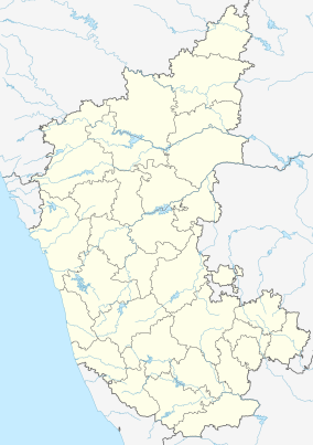
Uttara Kannada is a district in the Indian state of Karnataka. It is a major coastal district of Karnataka, and is the third largest district in Karnataka. It is bordered by the state of Goa and Belagavi districts to the north, Dharwad District and Haveri District to the east, Shivamogga District, and Udupi District to the south, and the Laccadive Sea to the west.

Sharavati is a river which originates and flows entirely within the state of Karnataka in India. It is one of the few westward flowing rivers of India and a major part of the river basin lies in the Western Ghats. The famous Jog Falls, located about 25 km from Siddapura, is formed by this river. The river itself and the regions around it are rich in biodiversity and are home to many rare species of flora and fauna.

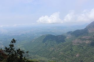
Kudremukha is the name of a mountain range and an individual mountain peak located in Chikmagaluru district, in Karnataka, India. It is also the name of a small hill station and iron ore-mining town situated near the mountain, about 20 kilometres from Kalasa in Kalasa Taluk. The name Kuduremukha literally means "horse-faced" in Kannada and refers to a particular picturesque view of a side of the mountain that resembles a horse's face. It was also referred to as 'Samseparvata', historically since it was approached from Samse village. Kuduremukha is Karnataka's 2nd highest peak after Mullayanagiri and 26th highest peak in western ghats. The nearest International Airport is at Mangalore which is at a distance of 99 kilometres.
The Nilgiri Biosphere Reserve is a biosphere reserve in the Nilgiri Mountains of the Western Ghats in South India. It is the largest protected forest area in India, spreading across Tamil Nadu, Karnataka and Kerala. It includes the protected areas Mudumalai National Park, Mukurthi National Park, Sathyamangalam Wildlife Sanctuary in Tamil Nadu; Nagarhole National Park, Bandipur National Park, both in Karnataka; Silent Valley National Park, Aralam Wildlife Sanctuary, Wayanad Wildlife Sanctuary, and Karimpuzha Wildlife Sanctuary in Kerala.

Agumbe is a village situated in the Thirthahalli taluka of Shivamogga district, Karnataka, India. It is nestled in the thickly forested Malenadu region of the Western Ghats mountain range. Owing to its high rainfall, it has received the epithet of "The Cherrapunji of South India", after Cherrapunji, one of the rainiest places in India.

Dibru-Saikhowa National Park is a national park located in Dibrugarh and Tinsukia districts, Assam, India. It was designated a Biosphere Reserve in July 1997 with an area of 765 km2 (295 sq mi), including a core area of 340 km2 (130 sq mi) and a buffer zone of 425 km2 (164 sq mi).

Kali Tiger Reserve is a protected area and tiger reserve. It is located in Uttara Kannada district, in Karnataka, India. The park is a habitat of Bengal tigers, black panthers and Indian elephants, amongst other distinctive fauna. The Kali River flows through the tiger reserve and is the lifeline of the ecosystem and hence the name. The tiger reserve is spread over an area of 1300 square kilometres.

Shimoga district, officially known as Shivamogga district, is a district in the Karnataka state of India. A major part of Shimoga district lies in the Malnad region or the Sahyadri. Shimoga city is its administrative centre. Jog Falls view point is a major tourist attraction. As of 2011 Shimoga district has a population of 17,52,753. There are seven taluks: Soraba, Sagara, Hosanagar, Shimoga, Shikaripura, Thirthahalli, and Bhadravathi. Channagiri and Honnali were part of Shimoga district until 1997 when they became part of the newly formed Davanagere district.

Bhadra Wildlife Sanctuary is a protected area and tiger reserve as part of the Project Tiger, situated in Chikkamagaluru district, 23 km (14 mi) south of Bhadravathi city, 38 km (24 mi) 20 km from Tarikere town, northwest of Chikkamagaluru and 283 km from Bengaluru city in Karnataka state, India. Bhadra sanctuary has a wide range of flora and fauna and is a popular place for day outings. The 1,875 m (6,152 ft) above MSL Hebbe Giri is the highest peak in the sanctuary.

Namdapha National Park is a 1,985 km2 (766 sq mi) large protected area in Arunachal Pradesh of Northeast India. The park was established in 1983. With more than 1,000 floral and about 1,400 faunal species, it is a biodiversity hotspot in the Eastern Himalayas. The national park harbours the northernmost lowland evergreen rainforests in the world at 27°N latitude. It also harbours extensive dipterocarp forests, comprising the northwestern parts of the Mizoram-Manipur-Kachin rain forests ecoregion.
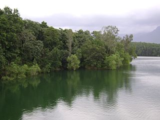
Lakkavalli is a small town / Hobli in Tarikere Taluk of Chikkamagaluru district, Karnataka state, southern India. Lakkavalli is the site of a dam across the Bhadra River; the dam is used for irrigation and power production and agriculture. Lakkavalli is malnad hobli of Tarikere taluk since it belongs to Malnad region. The biodiversity of the place is well known since the British. The Kuvempu University, which is one of the premier learning centre, is just 7 km from here. The state highway T-M Road passes through the village. A Jain Matha exists here and it is headed by Bhattaraka Swasti Sri Vrushabasena.

The state of Karnataka in South India has a rich diversity of flora and fauna. It has a recorded forest area of 38,720 km2 which constitutes 55 of the geographical area of the state. These forests support 25% of the elephant population and 20% of the tiger population of India. Many regions of Karnataka are still unexplored and new species of flora and fauna are still found. The mountains of the Western Ghats in the western region of Karnataka are a biodiversity hotspot. Two sub-clusters of the Western Ghats, Talacauvery and Kudremukh, are on a tentative list of sites that could be designated as World Heritage Sites by UNESCO. The Bandipur and Nagarahole national parks which fall outside these subclusters were included in the Nilgiri biosphere reserve in 1986, a UNESCO designation. In the Biligiriranga Hills the Eastern Ghats meet the Western Ghats. The state bird and state animal of Karnataka are Indian roller and the Indian elephant. The state tree and state flower are sandalwood and lotus. Karnataka is home to 524 tigers.

The Grizzled Squirrel Wildlife Sanctuary (GSWS), also known as Srivilliputhur Wildlife Sanctuary, was established in 1988 to protect the Near threatened grizzled giant squirrel. Occupying an area of 485.2 km2, it is bordered on the southwest by the Periyar Tiger Reserve and is one of the best preserved forests south of the Palghat Gap.
The Peppara Wildlife Sanctuary is a wildlife sanctuary in Thiruvananthapuram district of Kerala, India. It consists of the catchment area of the Karamana River, which originates from Chemmunjimottai, the tallest hill within the sanctuary. The sanctuary is named after the Peppara Dam, commissioned in 1983 to augment the drinking water supply to Thiruvananthapuram city and suburban areas. Considering the ecological significance of the area, it was declared a sanctuary in 1983. The terrain is undulating with elevation ranging from 100 m to 1717 m. The area of the sanctuary is 75 km2 with tropical moist evergreen forests and myristica swamps. It is part of the Agasthyamala Biosphere Reserve. Peppara Wildlife Sanctuary is 44 kilometres (27 mi) by car from the nearest railway station, at Thiruvananthapuram, and 49 kilometres (30 mi) from the Thiruvananthapuram airport.

Shendurney Wildlife Sanctuary is a protected area in the Western Ghats, India, located in Kollam district of Kerala and comes under the control of the Agasthyamalai Biosphere Reserve. It was established on 25 August 1984 and comprises 172.403 square kilometres (66.565 sq mi). The name is a corruption of the Chengurinji, a tree endemic to the region. The sanctuary has an artificial lake of nearly 18.69Sq.km size and also surrounded by the reservoir of Thenmala Dam. The Shendurney Wildlife Sanctuary is a treasure house of plant diversity. About 1257 species of flowering plants belonging to more than 150 families are reported from this sanctuary of which 309 species are endemic to Western Ghats. Birds from 267 species including migratory, endemic and endangered species have been reported here.
Someshwara Wildlife Sanctuary is a protected wildlife sanctuary in the Western Ghats of Karnataka state in India. It is named after the presiding deity "Lord Someshwara" of the famed Someshwara temple located within the sanctuary. The sanctuary lies in Udupi & Shivamogga districts of Karnataka, below Agumbe. The sanctuary houses Sitanadi nature camp run by Karnataka Forest Department. Udupi to Agumbe road passes through this wildlife sanctuary. The nearest town is Hebri which is connected by bus service to Udupi, Mangaluru and Bengaluru on a daily basis.
Nambor - Doigrung Wildlife Sanctuary is a Morangi located in Golaghat district of Assam in India. This wildlife sanctuary covers an area of 97.15 km2. It is located 25 km from Golaghat town and about 318 km from Guwahati LGBI Airport. The forest type is tropical semi-evergreen with pockets of pure evergreen, interspersed with small forest marshes. The area was declared as a Wildlife sanctuary in 2003. The sanctuary along with Garampani Wildlife Sanctuary and Nambor Wildlife Sanctuary (37 km2) are a part of the Kaziranga-Karbi Anglong Elephant Reserve, which was declared on 17 April 2003, with an estimated area of 3,270 km2.

Mysore-Ooty Road or Mysore-Udhagamandalam Road is a tourist trail of South India starting from Mysore in Karnataka state and ending in Udhagamandalam in Nilgiri district of Tamil Nadu state, India. Both routes pass through Bandipur National park in Gundlupet, Karnataka and Mudumalai National Park in Tamil Nadu.

Mookambika Wildlife Sanctuary is a protected wildlife sanctuary in the southern state of Karnataka in India. It derives its name from the presiding deity "Goddess Mookambika" of the popular Kollur Mookambika Temple. The sanctuary lies in the Western Ghats in Udupi district of Karnataka. The sanctuary consists of an area of 274 km2 (106 sq mi) was notified in the year 1974, by the Government of Karnataka vide notification AFD.48.FWL.74 dated 17 June 1974.

Karnataka is a state in India with rich archaeological and ecological heritage. The total geographical area of Karnataka is 191,976 square kilometres (74,122 sq mi) of which forest area is 37,550 square kilometres (14,500 sq mi) (19.58%).