
Multnomah Falls is a waterfall located on Multnomah Creek in the Columbia River Gorge, east of Troutdale, between Corbett and Dodson, Oregon, United States. The waterfall is accessible from the Historic Columbia River Highway and Interstate 84. Spanning two tiers on basalt cliffs, it is the tallest waterfall in the state of Oregon at 620 ft (189 m) in height. The Multnomah Creek Bridge, built in 1914, crosses below the falls, and is listed on the National Register of Historic Places.
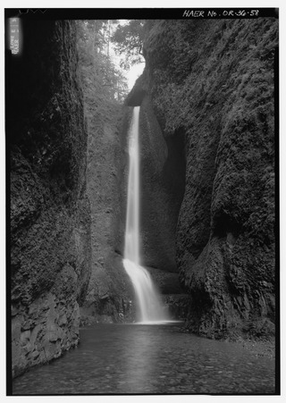
Oneonta Gorge is a scenic gorge located in the Columbia River Gorge area of the American state of Oregon. The U.S. Forest Service has designated it as a botanical area because of the unique aquatic and woodland plants that grow there. Exposed walls of 25-million-year-old basalt are home to a wide variety of ferns, mosses, hepatics, and lichens, many of which grow only in the Columbia River Gorge. Oneonta Gorge with its 50 species of wildflowers, flowering shrubs and trees has been described as "one of the true dramatic chasms in the state." The Oneonta Gorge Creek Bridge is listed on the National Register of Historic Places.

Barr Creek Falls, is a waterfall located in the Rogue River Canyon within the Prospect State Scenic Viewpoint in Jackson County, in the U.S. state of Oregon. The waterfall is located at the south end of Barr Creek as it plunges into the Rogue River over a carved cliff surrounded by walls of petrified volcanic ash as a consequence of the Mount Mazama eruption. The waterfall has also been called Bear Creek Falls. The waterfall gets its name from the creek which was called "Barr" for the presence of a fence that prevented cattle from straying out of the local Red Blanket Ranch and that ran adjacent to the creek.

The Bridal Veil Falls is a waterfall located on Bridal Veil Creek along the Columbia River Gorge in Multnomah County, Oregon, United States. The waterfall is accessible from the historic Columbia River Highway and Interstate 84. Spanning two tiers on basalt cliffs, it is the only waterfall which occurs below the historic Columbia Gorge Scenic Highway. The Bridal Veil Falls Bridge, built in 1914, crosses over the falls, and is listed on the National Register of Historic Places.
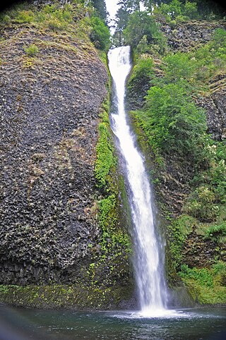
Horsetail Falls is a waterfall located on Horsetail Creek along the Columbia River Gorge in Multnomah County, in the U.S. state of Oregon. The falls drop over a cut over the columnar basalt cliff within the Oneonta Gorge. It is one of the waterfalls along the Columbia River Highway's waterfall corridor.

Latourell Falls is a waterfall along the Columbia River Gorge in the U.S. state of Oregon, within Guy W. Talbot State Park.

Shepperd's Dell is a small canyon in the Columbia River Gorge in Oregon, located at 45.54833°N 122.195°W which is less than one-third mile southeast of Rooster Rock State Park. The Shepperd's Dell Bridge is listed on the National Register of Historic Places.
Starvation Creek State Park is a state park located west of Hood River, Oregon in the Columbia River Gorge. It was named Starvation Creek because a train was stopped there by snow drifts and passengers had to dig out the train. No one starved there.

Silver Falls State Park is a state park in the U.S. state of Oregon, located near Silverton, about 20 miles (32 km) east-southeast of Salem. It is the largest state park in Oregon with an area of more than 9,000 acres (36 km2), and it includes more than 24 miles (39 km) of walking trails, 14 miles (23 km) of horse trails, and a 4-mile (6.4 km) bike path. Its 8.7-mile (14.0 km) Canyon Trail/Trail of Ten Falls runs along the banks of Silver Creek and by ten waterfalls, from which the park received its name. Four of the ten falls have an amphitheater-like surrounding that allows the trail to pass behind the flow of the falls. The Silver Falls State Park Concession Building Area and the Silver Creek Youth Camp-Silver Falls State Park are separately listed on the U.S. National Register of Historic Places.
Viento State Park is a state park in north central Hood River County, Oregon, near the city of Hood River. The park, named for the former Viento railroad station located there, is administered by the Oregon Parks and Recreation Department. The park is on the south bank of the Columbia River in the Columbia River Gorge. Interstate 84 and the Union Pacific Railroad pass through the park. It offers a seasonal, full-service campground, access to gorge hiking trails beyond park boundaries, a day-use area and river access for windsurfing and kiteboarding.

Mill Creek Falls, is a waterfall located in the Rogue River Canyon within the Prospect State Scenic Viewpoint in Jackson County, in the U.S. state of Oregon. The waterfall is located at the south end of Mill Creek as it plunges into the Rogue River over a carved cliff surrounded by walls of petrified volcanic ash consequence of Mount Mazama eruption.

Hole-in-the-Wall Falls, also known as Warren Falls, is a 96-foot man-made waterfall on Warren Creek in Starvation Creek State Park, Hood River County, Oregon, United States. Its main drop is 60 feet. It was created in 1938 when Warren Creek was diverted through a tunnel to prevent washouts of the Columbia River Highway. The creation of the falls shut off a natural cascade known as Warren Creek Falls named after the creek that formed it.

Frustration Falls, is a three drop waterfall located on the Salmon River at the south skirt of the Mount Hood National Forest, in Clackamas County, in the U.S. state of Oregon. It is located in a privileged area where the river creates several waterfalls: Final Falls, Vanishing Falls, Little Niagara Falls, and Copper Creek Falls are within a mile from Frustration Falls; while Hideaway Falls, Split Falls, and Stein Falls are approximately two miles away.
Final Falls, is a waterfall located on the Salmon River at the south skirt of the Mount Hood National Forest, in Clackamas County, in the U.S. state of Oregon. It is located in a privileged area where the river creates several waterfalls: Frustration Falls, Vanishing Falls, Little Niagara Falls, and Copper Creek Falls are within a mile from Final Falls; while Hideaway Falls, Split Falls, and Stein Falls are approximately two miles away.
Vanishing Falls, is a waterfall located on the Salmon River at the south skirt of the Mount Hood National Forest, in Clackamas County, in the U.S. state of Oregon. It is located in a privileged area where the river creates several waterfalls: Final Falls, Frustration Falls, Little Niagara Falls, and Copper Creek Falls are within a mile from Vanishing Falls; while Hideaway Falls, Split Falls, and Stein Falls are approximately two miles away.
Little Niagara Falls, is a waterfall located on the Salmon River at the south skirt of the Mount Hood National Forest, in Clackamas County, in the U.S. state of Oregon. It is located in a privileged area where the river creates several waterfalls: Final Falls, Vanishing Falls, Frustration Falls, and Copper Creek Falls are within a mile from Little Niagara Falls; while Hideaway Falls, Split Falls, and Stein Falls are approximately two miles away.

Fall Creek Falls, is a three to four drop waterfall located on the North Umpqua River at the west skirt of the Umpqua National Forest, in Douglas County, in the U.S. state of Oregon. It is located in a privileged natural area where the river creates several waterfalls: Susan Creek Falls, Emile Falls, and Grotto Falls are two to five miles away.
Wolf Creek Falls, is a two tier waterfall located on the west skirt of the Umpqua National Forest, in Douglas County, in the U.S. state of Oregon. It is located in a privileged area where rivers of the forest create several waterfalls: Cavitt Creek Falls, and Shadow Falls are within five miles of Wolf Creek Falls. Grotto Falls is further to the east off Little River Road and National Forest Road 2703.

Warren Creek Falls was a waterfall located in Starvation Creek State Park at the north skirt of the Columbia River Gorge, in Hood River County in the U.S. state of Oregon. It was located in a privileged area along the Historic Columbia River Highway, where several waterfalls are located in Starvation Creek State Park, including Cabin Creek Falls, Lancaster Falls, and Starvation Creek Falls—all within 2 miles (3 km) of each other. It is frequently referred to as the name for Hole-in-the-Wall Falls, a few yards downstream of Warren Creek.
Wahe Falls, also called Moffett Creek Falls, is an 80-foot waterfall on the Columbia River Gorge, Multnomah County, Oregon, United States. Wahe Falls is the last of several waterfalls along Moffett Creek. The mouth of the Creek is within the limits of the John B. Yeon State Scenic Corridor.

