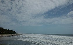
Azheekal Beach

Last updated

Azheekal Beach
അഴീക്കല്‍ ബീച്ച് near Azheekal
Beach
Azheeckal Beach, Kayamkulam.jpg
Azheekkal Beach
India Kerala location map.svg
Red pog.svg
Azheekal Beach
അഴീക്കല്‍ ബീച്ച് near Azheekal
Coordinates: 9°07′55.9164″N76°27′49.9392″E / 9.132199000°N 76.463872000°E / 9.132199000; 76.463872000
LocationAzheekal, Oachira Karunagappally, Kollam,more importantly it is the nearest beach to the some parts of pathanamthitta district and some parts of Alappuzha district.
Dimensions
  Length660 m
Hazard ratingLow
Access Karunagappally Aiga railtransportation 25.svg - 17 km,
Kollam BSicon BUS2.svg - 40 km,
Oachira Aiga railtransportation 25.svg - 9 km,

Azheekal Beach is an 800 meter long beach on the coast of the Arabian Sea, in Karunagappally Taluk of Kollam Metropolitan Area, Kerala, India. [1] The beach got this name from the Malayalam word Aazhee, which means confluence of backwaters and the Sea.

Contents

Location

Azheekal beach is located at the northern end of the land mass of Alappad peninsula in the district of Kollam in Kerala.

It is 12 km (7.45 mi) away from Kayamkulam and 14 km (8.69 mi) away from Karunagappally. It can be accessed through Azheekal-Ayiramthengu bridge, Panikkar Kadavu bridge or Kallum moottil kadavu bridge.

Azheekal Fishing Harbour is located near the beach.

It was impacted by the 2004 Indian Ocean earthquake and tsunami.

Related Research Articles

<span class="mw-page-title-main">Kollam</span> City in Kerala, India

Kollam, also known by its former name Quilon, is an ancient seaport and city on the Malabar Coast of India bordering the Laccadive Sea, which is a part of the Arabian Sea. It is 71 km (44 mi) north of the state capital Thiruvananthapuram. The city is on the banks of Ashtamudi Lake and the Kallada river. Kollam is the fourth largest city in Kerala and is known for cashew processing and coir manufacturing. It is the southern gateway to the Backwaters of Kerala and is a prominent tourist destination. Kollam is one of the most historic cities with continuous settlements in India. Geographically, Quilon formation seen around coastal cliffs of Ashtamudi Lake, represent sediments laid down in the Kerala basin that existed during Mio-Pliocene times.

<span class="mw-page-title-main">Kerala backwaters</span> Lagoon network in India

The Kerala backwaters are a network of brackish lagoons and canals lying parallel to the Arabian Sea of the Malabar coast of Kerala state in south-western India. It also includes interconnected lakes, rivers, and inlets, a labyrinthine system formed by more than 900 km (560 mi) of waterways, and sometimes compared to bayous. The network includes five large lakes linked by canals, both man made and natural, fed by 38 rivers, and extending virtually half the length of Kerala state. The backwaters were formed by the action of waves and shore currents creating low barrier islands across the mouths of the many rivers flowing down from the Western Ghats range. In the midst of this landscape there are a number of towns and cities, which serve as the starting and end points of backwater cruises. There are 34 backwaters in Kerala. Out of it, 27 are located either closer to Arabian Sea or parallel to the sea. The remaining 7 are inland navigation routes.

<span class="mw-page-title-main">Kollam district</span> District in Kerala, India

Kollam district, is one of 14 districts of the state of Kerala, India. The district has a cross-section of Kerala's natural attributes; it is endowed with a long coastline, a major Laccadive Sea seaport and an inland lake. The district has many water bodies. Kallada River is one among them, and land on the east bank of the river is East Kallada and that on the west bank is West Kallada.

<span class="mw-page-title-main">Chavara</span> Suburb & Block in Kollam, Kerala, India

Chavara is a village in Karunagappally taluk, Kollam district, Kerala, India. It is a part of Kollam Lok Sabha constituency. The current MLA of the Chavara constituency is Dr. Sujith Vijayan Pillai of the LDF.

Alappad is a coastal village in the Kollam district of the Indian state Kerala. It is situated on a narrow strip of land sandwiched between the Arabian Sea and the TS Canal – the village is approximately 16 km long and its narrowest point is as thin as 33 meters. Connect to the mainland is by bridge as well as by country boat ferries, operated by the Panchayat and private parties. Until recently there was only one bridge at the southern point of the land strip, but after the 2004 tsunami, two other bridges have been constructed. The protests are taking place in the village against Unscientific sand mining by IREL.

<span class="mw-page-title-main">Kallada River</span> River in South kerala

The Kallada River is the longest river in Kollam District, Kerala, India. The river originates in Kulathupuzha, in the Western Ghats, and flows west, reaching the Arabian Sea after traveling a distance of 120 km (75 mi).

<span class="mw-page-title-main">Oachira</span> Town in Kerala, India

Oachira or Ochira is an ancient temple town located 32 km away from Kollam city in Karunagappally taluk, Kollam district in Kerala, India.

Karunagappally is a municipality in the Kollam district of Kerala, India. It is 24 km north of Kollam and 60 km (37 mi) south of Alappuzha. Karunagappally taluk consists of Alappad, Ochira, Adinad, Karunagappally, Thazhava, Pavumba, Thodiyoor, Kallalibhagom, Thevalakkara, Chavara, Neendakara, Clappana, Kulasekharapuram, Thekkumbhagam, Ayanivelikulangara, Panmana, Ponmana and Vadakumthala. The taluk is bound on the north by Kayamkulam, on the east by Kunnathur taluk, on the south by Kollam and on the west by the Arabian Sea. It is one of the fastest developing towns in Kerala and is part of Kollam metropolitan area.

<span class="mw-page-title-main">Sasthamkotta</span> Village in Kerala, India

Sasthamkotta or Sasthamcotta is a village in the Kunnathoor Tehsil of Kollam district in the state of Kerala, India. Kunnathoor taluk headquarters is located at Sasthamkotta. The Sasthamkotta freshwater lake is the largest freshwater lake in Kerala.

<span class="mw-page-title-main">Chirayinkeezhu</span> Taluk in Kerala, India

Chirayinkeezhu is a town in Thiruvananthapuram district in the Indian state of Kerala. It was also hometown of famous Malayalam Film actor Prem Nazir. It is the seat of Chirayinkeezhu taluk.

Kappil is a seashore tourist spot located in Thiruvananthapuram district, Kerala, India. Varkala railway station is the major railway station near Kappil.

<span class="mw-page-title-main">Kavanad</span> Neighbourhood in Kollam, Kerala, India

Kavanad is a suburban area of Kollam Municipal Corporation in Kerala. It is a major market town located at the northern suburb of Kollam City in India. It is coming under Sakthikulangara zone of Kollam Municipal Corporation. It is just 3 km from the port town of Neendakara. Kavanad, a narrow strip of land sandwiched between the Arabian Sea and the Ashtamudi Lake has one of the highest land values in Kollam city. The town emerged as a major shopping destination in Kollam with the advent of a number of shopping centres. A number of vehicle showrooms are also located at Kavanad-Ramankulangara-Mulamkadakam stretch. The long anticipated Kollam bypass starts just a kilometer before Kavanad from the place called Altharamoodu and was completed in January 2019, Kavanadu had become a major vantage point en route to Trivandrum from Alappuzha and is a fast developing satellite town within Kollam Metropolitan Area. You can also find 24 hr working shops in Kavanad which is a rarity in Kerala. Kavanadu is a major tourist attraction of Kollam district.

<span class="mw-page-title-main">Neendakara</span> Urban Village in Kerala, India

Neendakara is a suburb of Kollam city in Kerala, India .The twin harbours, Neendakara and Shakthikulangara are located here. |url=https://www.tourmyindia.com/states/kerala/neendakara-port-kollam.html Trawling ban and withdrawal of the state official start from Neendakara harbour. It is about 10km away from the city center.

<span class="mw-page-title-main">Akalapuzha Lake</span> Lake in Kerala, India

Akalapuzha is a lake situated in the Kozhikode, Kerala. Flowing as a distributory of Korapuzha from Kanayankodu in Koyilandy, Akalapuzha flows northwest to meet the Kuttiyadipuzha at Payyoli Chirp.

Panakkattodil Devi Temple is a Hindu temple in Chavara Thekkumbhagom village in Kollam district of the Indian state of Kerala. Primary deity of this temple is Durga. The temple is managed by the Travancore Devaswom Board, Kerala. The Thalappoli in 'Meda Bharani' and the annual festival during the months of April and May are popular.

<span class="mw-page-title-main">Kuzhithura</span> Village in Kerala, India

Kuzhithura is a village in the Kollam district of the Indian state of Kerala. Kuzhithura is part of Alappad panchayat, which is part of the Karunagappally Taluk, situated on a narrow strip of land sandwiched between the Arabian Sea and the Thiruvananthapuram–Shoranur canal. It is a tourist destination with green land, backwaters, and beaches.

Srayikkadu is a coastal village in Kerala, India. It is in Kollam district. Srayikkadu is part of Alappad panchayat which is part of karunagappally Taluk situated on a narrow strip of land sandwiched between the Arabian Sea and the T S Canal.The village is connected to the mainland by bridges as well as by country boat ferries. The main nearby places Karunagappally, Kayamkulam, Ochira are connected by roads. By water, it is connected to various places like Alappuzha, Kollam. Mata Amritanandamayi Math is 1 km away from this small village as well. It is a green land with backwaters and beaches.

<span class="mw-page-title-main">UKF College of Engineering and Technology</span>

The UKF College of Engineering and Technology is an engineering college situated in Kalluvathukal Panchayath of Kollam district in Kerala, India. It is situated 9 km away from Varkala town, 24 km away from Kollam City and 48 km away from state capital city Trivandrum. Established in 2009, it is affiliated to the Kerala Technological University headquartered in Trivandrum city. UKF College of Engineering & Technology is owned and managed by the Universal Knowledge Foundation Trust.

Manppally is a small village located near Thazhava, Kollam district, Kerala, India.

References

  1. "Azheekal Beach Near Karunagappally Kollam". www.dtpckollam.com.