
Greene County is a county located in the U.S. state of Arkansas. As of the 2010 census, the population was 42,090. The county seat is Paragould, which sits atop Crowley's Ridge.

Cross County is a rural Northeast Arkansas county in the Arkansas Delta. Created as Arkansas's 53rd county on November 15, 1862, Cross County contains four incorporated municipalities, including Wynne, the county seat and most populous city. It is named for Confederate Colonel David C. Cross, a political leader in the area.

Crowley's Ridge is a geological formation that rises 250 to 550 feet (170 m) above the alluvial plain of the Mississippi embayment in a 150-mile (240 km) line from southeastern Missouri to the Mississippi River near Helena, Arkansas. It is the most prominent feature in the Mississippi Alluvial Plain between Cape Girardeau, Missouri, and the Gulf of Mexico.

Crowley's Ridge State Park is a 291-acre (118 ha) Arkansas state park in Greene County, Arkansas in the United States atop Crowley's Ridge. Located on the former homesite of pioneer Benjamin Crowley, the park contains many excellent examples of the work done by the Civilian Conservation Corps in the 1930s. One of Arkansas's most popular state parks, the parks is bisected by Crowley's Ridge Parkway, a National Scenic Byway. The site became a state park in 1933 in an effort to honor Crowley and the heritage of the Crowley's Ridge area.
Benjamin Crowley II (c.1758—1842) was an early settler of Arkansas.

Crowley's Ridge Parkway is a 212.0-mile-long (341.2 km) National Scenic Byway in northeast Arkansas and the Missouri Bootheel along Crowley's Ridge in the United States. Motorists can access the parkway from US Route 49 (US 49) at its southern terminus near the Helena Bridge over the Mississippi River outside Helena-West Helena, Arkansas, or from Missouri Route 25 (Route 25) near Kennett, Missouri. The parkway runs along Crowley's Ridge, a unique geological formation, and also parts of the St. Francis National Forest, the Mississippi River and the Mississippi Alluvial Plain. Along the route are many National Register of Historic Places properties, Civil War battlefields, parks, and other archeological and culturally significant points.

U.S. Route 62 is a U.S. highway running from El Paso, Texas northeast to Niagara Falls, New York. In the U.S. state of Arkansas, the route runs 329.9 miles from the Oklahoma border near Summers east to the Missouri border in St. Francis, serving the northern portion of the state. The route passes through several cities and towns, including Fayetteville, Springdale, Bentonville, Harrison, Mountain Home, Pocahontas, and also Piggott. US 62 runs concurrent with several highways in Arkansas including Interstate 49 and U.S. Route 71 between Fayetteville and Bentonville, U.S. Route 412 through much of the state, U.S. Route 65 in the Harrison area, and with U.S. Route 63 and U.S. Route 67 in northeast Arkansas.
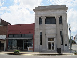
The National Bank of Commerce Building is a historic commercial building at 200 S. Pruett St. in downtown Paragould, Arkansas. It is a two-story structure, built out of cut stone, with a center entrance recessed in a two-story opening with flanking Ionic columns. This Classical Revival style building, probably the finest of its style in Greene County, and the least-altered bank building of the period in Paragould, was designed by the Memphis firm of Hankers and Cairns and was built in 1923.
Arkansas Highway 168 is an east–west state highway in Greene County, Arkansas. The route of 8.59 miles (13.82 km) runs from Highway 228 east through Crowley's Ridge State Park to US Route 412 (US 412). A segment of the route composes the Crowley's Ridge Parkway.
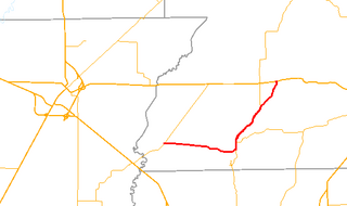
Highway 163 is a north–south state highway in Northeast Arkansas. The highway begins at Wittsburg and runs 42.57 miles (68.51 km) northeast to Highway 1, Highway 1 Business (AR 1B) and Crowley's Ridge Parkway (CRP) in Jonesboro. A spur route runs in Jonesboro. All routes are maintained by the Arkansas Department of Transportation (ArDOT). Almost all of the route is concurrent with Crowley's Ridge Parkway, with a portion also serving as an Arkansas Heritage Trail for its use during the Civil War.
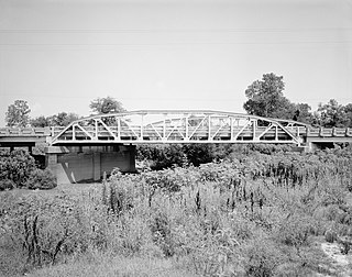
The Cache River Bridge is a Parker pony truss that spans the Cache River between Walnut Ridge and Paragould, Arkansas. It was built in 1934 by the Arkansas State Highway Commission and was designed by the Vincennes Bridge Company. Formerly carrying U.S. Route 412 and earlier Arkansas Highway 25, the structure was added to the National Register of Historic Places in 1990, and was bypassed by a new bridge in 1995.

Powhatan Historic State Park is a 9.1-acre (3.7 ha) Arkansas state park in Lawrence County, Arkansas in the United States. The park contains the 1888 Powhatan courthouse which served as the home of county government from 1869-1968. Today the structure displays items of cultural and historical significance and hosts the park's Visitor Center. The park includes four additional historical buildings and the Arkansas History Commission's Northeast Arkansas Regional Archives. A tour of the historic structures is available. Powhatan served as an important stop for traffic on the Black River until the installation of the Kansas City-Memphis Railwayline two miles north in 1883 significantly decreased the need for river transportation.
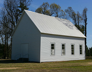
The Old Bethel Methodist Church, also known as the Old Bethel School, Church, & Cemetery, is a historic Methodist church, school and cemetery in rural Greene County, Arkansas. It is located on Highway 358,& Greene 712 Road in Paragould, Arkansas. It is a modest single-story wood frame structure, built in 1901, and standing next to a cemetery established in 1882. The original Bethel Methodist Church was constructed in 1880, a small, onestory, white frame church. In 1900, a storm destroyed this building and in 1901 an almost identical building replaced the original structure. George Russell, a local carpenter, built the building using native materials of cypress and pine. It measures 20 feet by 40 feet and has a high pitched roof covered by tin. Exterior walls are covered with six inch beveled pine siding, while interior walls and ceiling are beaded pine wall board. Adjacent to it is a cemetery that dates to 1886.The first person buried here was Moss Widner in 1882. The building served the small community of Finch as not just a church, but also as a school, and was vacated in 1941. It was restored in the 1970s by a group of local concerned citizens, and is occasionally used for services.

Lake Frierson State Park is a 114-acre (46 ha) Arkansas state park on Crowley's Ridge in Greene County, eastern Arkansas.
The Wittsburg Fortification is a defensive earthworks built during the American Civil War in Wittsburg, Arkansas. It is the only known surviving earthworks built by either side during the Union Army's advance on Little Rock in 1862. Union forces invaded Arkansas from Missouri on July 19, 1862, moving south along Crowley's Ridge, which lies west of the St. Francis River. By July 29 most of the division of General John Davidson had advanced as far as Wittsburg, where they established a camp to wait for supplies and reinforcements. A stockade and ditch were built on the ridge overlooking the area.

The Crowley's Ridge State Park Bridge is a historic masonry stone arch bridge in Crowley's Ridge State Park, near Walcott, Arkansas. The bridge carries the main access road to the park across a drainage ditch. It is a rusticated stone structure, about 40 feet (12 m) long, that was built c. 1935 by crews of the Civilian Conservation Corps (CCC) that were developing the park. It is one of several CCC-built structures still standing in the park, and is a well-built example of the rustic architecture popularized by the CCC.

The Crowley's Ridge State Park Bathhouse is a historic recreational facility in Crowley's Ridge State Park, located in Greene County, Arkansas. It is a 1-1/2 story log structure, built on a fieldstone foundation, and is covered with a hip roof. A wood and log frame ell extends to the building's rear. The bathhouse was built c. 1935 by a crew from the Civilian Conservation Corps, and is an excellent local example of the Rustic style architecture popularized by the CCC.

The Crowley's Ridge State Park Comfort Station is a historic visitor facility at Crowley's Ridge State Park, in Greene County, Arkansas. Located in the campground section of the park, it is a single-story log structure with a gable roof, in which are latrine facilities. It was built c. 1933 by a crew of the Civilian Conservation Corps, and is a well-preserved example of the Rustic style architecture the CCC popularized.
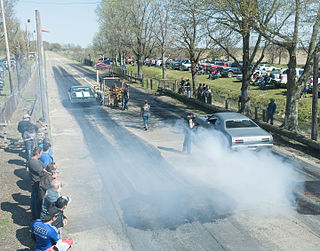
George Ray's Dragstrip is an automotive drag racing strip in Paragould, Arkansas. Built in 1961 by the famous George Ray, it is the oldest single-purpose drag racing facilities in Arkansas. It is located on Arkansas Highway 135, east of Paragould, with racing occurring every Sunday. Its facilities include a concrete racing strip 2,960 feet (900 m) long and 31 feet (9.4 m) wide, with bleachers along the sides and a spectator catwalk. The facility was listed on the National Register of Historic Places in 2006.

The former Greene County Courthouse is located at Courthouse Square in the center of Paragould, the county seat of Greene County, Arkansas. It is a large two-story Georgian Revival structure, built out of red brick. It has a low-pitch hip roof with small gables at three corners, as well as above the entrances. The roof is topped by a square tower with a clock and belfry, topped by an ogee roof and spire. It was built in 1887, and was the sixth courthouse built for the county, most of the others having been destroyed by fire.


