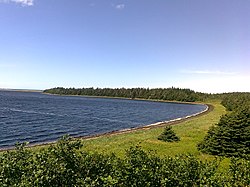
Frenchman's Cove | |
---|---|
Coordinates: 47°12′56″N55°24′21″W / 47.2156°N 55.4058°W Coordinates: 47°12′56″N55°24′21″W / 47.2156°N 55.4058°W | |
Country | Canada |
Province | Newfoundland and Labrador |
Area | |
• Land | 68.55 km2 (26.47 sq mi) |
Population | |
• Total | 159 |
• Density | 2.5/km2 (6/sq mi) |
Time zone | UTC-3:30 (Newfoundland Time) |
• Summer (DST) | UTC-2:30 (Newfoundland Daylight) |
Area code | 709 |
Highways | Route 210 Route 213 |
Frenchman's Cove is a town on the west coast of Burin Peninsula, Newfoundland and Labrador, Canada. It had a population of 159 in the Canada 2021 Census, a drop from 172 in 2011. The town has been inhabited since before 1836, the earliest known documentation about it, when it appeared in the first Newfoundland Census. According to local folklore and tradition, the first settlers were named Cleuetts and were of French origin. The small-boat inshore fishery was the economic mainstay of the area until the late 1800s when did men went work on the schooners operating from Grand Bank. Residents also grew turnips, cabbages, and potatoes, as well as hay for their horses, cattle, sheep, and chickens. [3]
Nearby Frenchman's Cove Provincial Park, is next to a large barachois, sand and mud flats, mixed forest, and tidal lagoons. Wildlife in the area includes sea and terrestrial birds, including Canada Geese. [3]
In the 2021 Census of Population conducted by Statistics Canada, Frenchman's Cove had a population of 159 living in 78 of its 126 total private dwellings, a change of -5.9% from its 2016 population of 169. With a land area of 69.07 km2 (26.67 sq mi), it had a population density of 2.3/km2 (6.0/sq mi) in 2021. [2]
Gambo is a town and designated place in the Canadian province of Newfoundland and Labrador. It is in the northeastern portion of the island of Newfoundland on Freshwater Bay. It is in Division No. 7.
Division 1, Newfoundland and Labrador is a census division covering the entire Avalon Peninsula including the Isthmus of Avalon of the Canadian province of Newfoundland and Labrador. Like all census divisions in Newfoundland and Labrador, but unlike the census divisions of some other provinces, the division exists only as a statistical division for census data, and is not a political entity.
Division No. 8 is a census division on the north coast of the island of Newfoundland in the province of Newfoundland and Labrador, Canada. It has a land area of 9,314.57 km² and had a population of 35,794 at the 2016 census. Its largest communities are the towns of Lewisporte, Springdale, and Twillingate.
Tors Cove is a local service district and designated place in the Canadian province of Newfoundland and Labrador. It is on the east coast of the Avalon Peninsula of the island of Newfoundland, approximately 40 kilometres south of the St. John's, the provincial capital, along Route 10. It was formerly named Toads Cove.
Census Division No. 9 is composed of the area of the province of Newfoundland and Labrador called the Northern Peninsula. It has a land area of 13,527.12 km² and had a population of 15,607 at the 2016 census. The largest community is the town of St. Anthony, near its northern tip, on the Atlantic Ocean coast.
Bird Cove is a town in the Canadian province of Newfoundland and Labrador.
Bishop's Cove is a town in the Canadian province of Newfoundland and Labrador situated in Spaniard's Bay on the Avalon Peninsula.
Brent's Cove is a town in the Canadian province of Newfoundland and Labrador.
Bryant's Cove is a town in the Canadian province of Newfoundland and Labrador.
Chance Cove is a town in the Canadian province of Newfoundland and Labrador. The town had a population of 213 in the Canada 2021 Census.
Cox's Cove is a town in the Canadian province of Newfoundland and Labrador. The town had a population of 664 in the Canada 2021 Census. The small community is mainly based on the fishery, mink farm, and construction industries.
Humber Arm South is a town in the Canadian province of Newfoundland and Labrador. The town had a population of 1,537 in the Canada 2021 Census. The Town's Post Office is located in the section of the town referred to as Benoit's Cove. Humber Arm South is located in the Bay of Islands, and is in the Humber-Bay of Islands electoral district.
Lewin's Cove is a town in the Canadian province of Newfoundland and Labrador. The town had a population of 546 in the Canada 2021 Census.
Miles Cove is a town on Sunday Cove Island in the Canadian province of Newfoundland and Labrador. The town had a population of 104 in 2016, down from 140 in the Canada 2006 Census.
Parker's Cove or Parkers Cove is a town in the Canadian province of Newfoundland and Labrador. The town had a population of 233 in the Canada 2021 Census, a drop from 248 in 2016.
Sally's Cove is a town in the Canadian province of Newfoundland and Labrador. It is located on the west coast of the island of Newfoundland, and is surrounded by Gros Morne National Park. The town had a population of 15 in the Canada 2021 Census.
L'Anse-au-Loup is a town in the Canadian province of Newfoundland and Labrador. The town had a population of 692 in the Canada 2021 Census, up from 550 in 2011. In the Canada 2006 Census, there were 593 inhabitants. Common Surnames are Barney, Belben, Cabot, Earle, Linstead, Normore, O'Brien, Ryland.
Birchy Cove is a local service district and designated place in the Canadian province of Newfoundland and Labrador.
Division No. 2, Newfoundland and Labrador is a census division in the Canadian province of Newfoundland and Labrador, primarily comprising the Burin Peninsula. Like all census divisions in Newfoundland and Labrador, but unlike the census divisions of some other provinces, the division exists only as a statistical division for census data, and is not a political entity.