Outline of Zambia

Last updated

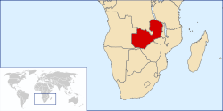
The location of Zambia LocationZambia.svg
The location of Zambia
An enlargeable map of the Republic of Zambia Zambiamap.png
An enlargeable map of the Republic of Zambia

The following outline is provided as an overview of and topical guide to Zambia:

Contents

Zambia landlocked sovereign country located in Southern Africa. [1] Zambia has been inhabited for thousands of years by hunter-gatherers and migrating tribes. After sporadic visits by European explorers starting in the 18th century, Zambia was gradually claimed and occupied by the British as protectorate of Northern Rhodesia towards the end of the nineteenth century. On 24 October 1964, the protectorate gained independence with the new name of Zambia, derived from the Zambezi river which flows through the country. After independence the country moved towards a system of one party rule with Kenneth Kaunda as president. Kaunda dominated Zambian politics until multiparty elections were held in 1991.[ citation needed ]
General reference

An enlargeable basic map of Zambia Zambia-CIA WFB Map.png
An enlargeable basic map of Zambia

Geography of Zambia

An enlargeable topographic map of Zambia Zambia Topography.png
An enlargeable topographic map of Zambia

Geography of Zambia

Flag of the Democratic Republic of the Congo.svg  Democratic Republic of the Congo 1,930 km
Flag of Angola.svg  Angola 1,110 km
Flag of Malawi.svg  Malawi 837 km
Flag of Zimbabwe.svg  Zimbabwe 797 km
Flag of Mozambique.svg  Mozambique 419 km
Flag of Tanzania.svg  Tanzania 338 km
Flag of Namibia.svg  Namibia 233 km
Flag of Botswana.svg  Botswana 1 km
  • Coastline: none

Environment of Zambia

An enlargeable satellite image of Zambia Zambia BMNG.png
An enlargeable satellite image of Zambia

Natural geographic features of Zambia

Regions of Zambia

Regions of Zambia

Ecoregions of Zambia

List of ecoregions in Zambia

Administrative divisions of Zambia

Administrative divisions of Zambia

Provinces of Zambia
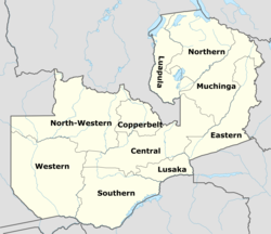
The provinces of Zambia Zambia provinces named.png
The provinces of Zambia

Provinces of Zambia Zambia is divided into ten provinces:

Districts of Zambia

Districts of Zambia The nine provinces of Zambia are divided into a total of 72 districts:

Municipalities of Zambia

Municipalities of Zambia

Demography of Zambia

Demographics of Zambia

Government and politics of Zambia

Politics of Zambia

Branches of the government of Zambia

Government of Zambia

Executive branch of the government of Zambia

Legislative branch of the government of Zambia

Judicial branch of the government of Zambia

Court system of Zambia

  • Supreme Court of Zambia
    • High court
    • Magistrate's court
    • Local courts

Foreign relations of Zambia

Foreign relations of Zambia

International organization membership

International organization membership of Zambia The Republic of Zambia is a member of: [1]

Law and order in Zambia

Law of Zambia

Military of Zambia

Military of Zambia

Local government in Zambia

Local government in Zambia

History of Zambia

History of Zambia

History of Zambia

Archaeological sites

See also Kalambo Falls in the Geography list above

Disasters

Topic

Culture of Zambia

Culture of Zambia

Art in Zambia

Music of Zambia

Music of Zambia

Musical groups

Languages of Zambia

Languages of Zambia

People of Zambia

People of Zambia

Specific Zambians

Religion

Religion in Zambia

Sport in Zambia

Sport in Zambia

Football in Zambia

Football competitions
Football venues
Football clubs

Other sports

Zambia at the Olympics

Economy and infrastructure of Zambia

Economy of Zambia

Education in Zambia

Education in Zambia

See also

Zambia

Related Research Articles

<span class="mw-page-title-main">Zambia</span> Country in South-Central Africa

Zambia, officially the Republic of Zambia, is a landlocked country at the crossroads of Central, Southern and East Africa. It is typically referred to being in South-Central Africa or Southern Africa. It is bordered to the north by the Democratic Republic of the Congo, Tanzania to the north-east, Malawi to the east, Mozambique to the southeast, Zimbabwe and Botswana to the south, Namibia to the southwest, and Angola to the west. The capital city of Zambia is Lusaka, located in the south-central part of Zambia. The population is concentrated mainly around Lusaka in the south and the Copperbelt Province to the north, the core economic hubs of the country.

The history of Zambia experienced many stages from colonisation to independence from Britain on 24 October 1964. Northern Rhodesia became a British sphere of influence in the present-day region of Zambia in 1888, and was officially proclaimed a British protectorate in 1924. After many years of suggested mergers, Southern Rhodesia, Northern Rhodesia, and Nyasaland were merged into the British Federation of Rhodesia and Nyasaland.

This article is about the Transport in Zambia.

<span class="mw-page-title-main">Zambezi</span> Major river in southern Africa

The Zambezi is the fourth-longest river in Africa, the longest east-flowing river in Africa and the largest flowing into the Indian Ocean from Africa. Its drainage basin covers 1,390,000 km2 (540,000 sq mi), slightly less than half of the Nile's. The 2,574 km (1,599 mi) river rises in Zambia and flows through eastern Angola, along the north-eastern border of Namibia and the northern border of Botswana, then along the border between Zambia and Zimbabwe to Mozambique, where it crosses the country to empty into the Indian Ocean.

<span class="mw-page-title-main">Luangwa River</span> River in Zambia

The Luangwa River is one of the major tributaries of the Zambezi River, and one of the four biggest rivers of Zambia. The river generally floods in the rainy season and then falls considerably in the dry season. It is one of the biggest unaltered rivers in Southern Africa and the 52,000 square kilometres (20,000 sq mi) that make up the surrounding valley are home to abundant wildlife.

<span class="mw-page-title-main">Livingstone, Zambia</span> City in Southern Province, Zambia

Livingstone is a city in Zambia. Until 1935, it served as the capital of Northern Rhodesia. Lying 10 km (6 mi) to the north of the Zambezi River, it is a tourism attraction center for the Victoria Falls and a border town with road and rail connections to Zimbabwe on the other side of the Victoria Falls. A historic British colonial city, its present population was enumerated at 177,393 inhabitants at the 2022 census. It is named after David Livingstone, the Scottish explorer and missionary who was the first European to explore the area. Until 2011, Livingstone was the provincial capital of Zambia's Southern Province.

<span class="mw-page-title-main">Kabwe</span> Town in Central Province, Zambia

Kabwe is the capital of the Zambian Central Province and the Kabwe District, with a population estimated at 202,914 at the 2010 census. Named Broken Hill until 1966, it was founded when lead and zinc deposits were discovered in 1902. Kabwe also has a claim to being the birthplace of Zambian politics as it was an important political centre during the colonial period.

<span class="mw-page-title-main">Great East Road</span> Major road in Zambia

The Great East Road is a major road in Zambia and the main route linking its Eastern Province with the rest of the country. It is also the major link between Zambia and Malawi and between Zambia and northern Mozambique. However, the route does not carry as much traffic as many of the other regional arterial roads and between the main cities it serves, Lusaka and Chipata, it passes through rural and wilderness areas. In Lusaka the road forms the main arterial road for the eastern suburbs. The entire route from Lusaka to Chipata and the border with Malawi is designated the T4 road on Zambia's road network.

<span class="mw-page-title-main">Luapula Province</span> Province of Zambia

Luapula Province is one of Zambia's ten provinces located in the northern part of the country. Luapula Province is named after the Luapula River and its capital is Mansa. As per the 2022 Zambian census, the Province had a population of 1,519,478, which accounted for 7.72 per cent of the total Zambian population.

<span class="mw-page-title-main">Lusaka Province</span> Province of Zambia

Lusaka Province is one of the ten provinces of Zambia. Its capital is Lusaka, which is also the national capital. It is the smallest province in Zambia, with an area of 21,896 km2. Lusaka is also Zambia's most populated and most densely populated province, with a population of 3,079,964 and density of 140 persons per km2 as of 2022. It is the most urban province, with the most doctors and fewest malaria-related incidents. The province is bordered by Zimbabwe and Mozambique, and separated by the Lower Zambezi National Park.

<span class="mw-page-title-main">Luangwa Bridge</span>

The Luangwa Bridge is the only large bridge and the principal engineering challenge on Zambia's Great East Road, crossing the lower Luangwa River where it flows from the Luangwa Rift Valley into the Zambezi valley.

This article gives lists of the National Monuments and other historic sites of Zambia, with a one- or two-line description providing links to details given on other pages.

Luangwa is a town in Zambia, at the confluence of the Luangwa and Zambezi Rivers, which was called Feira until 1964. It is headquarters of a district of the same name in Lusaka Province.

<span class="mw-page-title-main">Wildlife of Zambia</span>

The wildlife of Zambia refers to the natural flora and fauna of Zambia. This article provides an overview, and outline of the main wildlife areas or regions, and compact lists of animals focusing on prevalence and distribution in the country rather than on taxonomy. More specialized articles on particular groups are linked from here.

The biomes and ecoregions in the ecology of Zambia are described, listed and mapped here, following the World Wildlife Fund's classification scheme for terrestrial ecoregions, and the WWF freshwater ecoregion classification for rivers, lakes and wetlands. Zambia is in the Zambezian region of the Afrotropical biogeographic realm. Three terrestrial biomes are well represented in the country . The distribution of the biomes and ecoregions is governed mainly by the physical environment, especially climate.

Zambia, officially known as the Republic of Zambia, is a landlocked country in Southern Africa. The neighbouring countries are the Democratic Republic of the Congo to the north, Tanzania to the north-east, Malawi to the east, Mozambique, Zimbabwe, Botswana, and Namibia to the south, and Angola to the west. The capital city is Lusaka, located in the southeast of the country. The population is concentrated mainly around the capital and the Copperbelt to the northwest.

<span class="mw-page-title-main">Lusaka</span> Capital and largest city of Zambia

Lusaka is the capital and largest city of Zambia. It is one of the fastest-developing cities in southern Africa. Lusaka is in the southern part of the central plateau at an elevation of about 1,279 metres (4,196 ft). As of 2019, the city's population was about 3.3 million, while the urban population is estimated at 2.5 million in 2018. Lusaka is the centre of both commerce and government in Zambia and connects to the country's four main highways heading north, south, east, and west. English is the official language of the city administration, while Bemba and Nyanja are the commonly spoken street languages.

Tourism in Zambia relates to tourism in the African nation Zambia. The tourism industry is a major and growing industry in Zambia. Zambia has more than 2500 lions along with several National parks, waterfalls, lakes, rivers, and historic monuments. Zambia has been involved in several agreements on tourism with nations like Uganda and Kenya. Uganda Ministry of Tourism and Arts said Zambia is a model in tourism in Africa. Zambia Tourism Agency (ZTA) has partnered with the Government through the Ministry of Tourism and private sector to enhance the marketing aspect in the tourism industry.

References

  1. 1 2 "Zambia". The World Factbook . United States Central Intelligence Agency. 3 July 2009. Retrieved 23 July 2009.
  2. The only glaciers in Africa are on Mt Kenya (in Kenya), on Kilimanjaro (in Tanzania), and in the Ruwenzori Mountains (which are located in Uganda and the Democratic Republic of the Congo). See Proceedings of the Riederalp Workshop, September 1978; Actes de l'Atelier de Riederalp, septembre 1978): IAHS-AISH Publ. no. 126, 1980.

Gnome-globe.svg Wikimedia Atlas of Zambia