Woodlands, London

Last updated

Woodlands
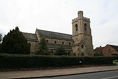
St. John the Baptist Church, Isleworth - geograph.org.uk - 744683.jpg
St John the Baptist Church
Greater London UK location map 2.svg
Red pog.svg
Woodlands
Location within Greater London
Population11,408 (Hounslow South ward 2011)
London borough
Ceremonial county Greater London
Region
Country England
Sovereign state United Kingdom
Post town ISLEWORTH
Postcode district TW7
Dialling code 020
Police Metropolitan
Fire London
Ambulance London
UK Parliament
London Assembly
List of places
UK
England
London
51°28′10″N0°20′15″W / 51.469568°N 0.337465°W / 51.469568; -0.337465

Woodlands is a small area located in the borough of Hounslow, London between Hounslow and Isleworth. It is an area roughly bounded by the Hounslow Loop railway line and the London Road to the north; the Duke of Northumberland's River and Twickenham Road to the east; and Bridge Road / Worton Road to the south and south-west. It includes roads such as Woodlands Road, Woodland Gardens, Woodlands Grove as well as The Woodlands Tavern public house and St John the Baptist's Church on St John's Road. [1]

The estate comprises mostly semi-detached houses built in the 1930s, although there are older buildings too. Before these houses were built the area was used as orchards, hence the name 'Woodlands'.

There is an organisation known as the WERFA (Woodlands Estate Resident Freeholders Association) which has a community hall in the small private park in the centre of Woodland Gardens.

Related Research Articles

<span class="mw-page-title-main">Hounslow</span> Town in the west of London, England

Hounslow is a large suburban district of West London, England, 10+34 miles west-southwest of Charing Cross. It is the administrative centre of the London Borough of Hounslow, and is identified in the London Plan as one of the 14 metropolitan centres in Greater London.

<span class="mw-page-title-main">Chiswick</span> Riverside district of London, England

Chiswick is a district in the London Borough of Hounslow, West London, England. It contains Hogarth's House, the former residence of the 18th-century English artist William Hogarth; Chiswick House, a neo-Palladian villa regarded as one of the finest in England; and Fuller's Brewery, London's largest and oldest brewery. In a meander of the River Thames used for competitive and recreational rowing, with several rowing clubs on the river bank, the finishing post for the Boat Race is just downstream of Chiswick Bridge.

<span class="mw-page-title-main">Gunnersbury</span> Area of west London, England

Gunnersbury is an area of West London, England.

<span class="mw-page-title-main">Isleworth</span> Suburb of West London

Isleworth is a suburban town in the London Borough of Hounslow, West London, England.

<span class="mw-page-title-main">West Norwood</span> Suburb of London

West Norwood is a largely residential area of south London within the London Borough of Lambeth, located 5.4 miles (8.7 km) south south-east of Charing Cross. The centre of West Norwood sits in a bowl surrounded by hillsides on its east, west and south sides. From many parts of the area, distant views can be seen, of places such as the City of London, Canary Wharf and Crystal Palace.

<span class="mw-page-title-main">St Margarets, London</span> Human settlement in England

St Margarets is an affluent suburb and neighbourhood in the London Borough of Richmond upon Thames, about 9 miles (14 km) west-southwest of central London. It is bounded by the Thames Tideway to the north-east, and the River Crane to the north-west and north where the land tapers between those rivers. Land and buildings closer to Richmond Bridge than the eponymous railway station are, traditionally distinctly, known as East Twickenham. Both places go by their post town and traditional parish, Twickenham quite often; in the 19th century the south of St Margarets was marked on maps as Twickenham Park.

<span class="mw-page-title-main">Kingston Vale</span> District in Kingston upon Thames, London

Kingston Vale with Kingston Hill is a district in the Royal Borough of Kingston upon Thames in south-west London. It is a residential area between Richmond Park, the much smaller Putney Vale, Wimbledon Common, Coombe/Coombe Hill and the Norbiton part of the very old borough. The main road is the A308 which is a through route for traffic passing to and from Kingston Hill to the A3 trunk road. Many of the branch roads are cul-de-sacs. It includes, toward the east and in the Vale, the only part of Kingston which drains eastward, that is, into Beverley Brook. The hill expanse, shared with Coombe and a golf course, has a hotel, some tall blocks overlooking Kingston, the edge of Kingston Hospital, the main campus of Kingston University London and faint remnants of dense woodland.

<span class="mw-page-title-main">Stanwell</span> Village and parish in Surrey, England

Stanwell is a village in the Spelthorne district, in Surrey, England. It is 16 miles (26 km) west of central London. A small corner of its land is used as industrial land for nearby Heathrow Airport. The rest of the village is made up of residential and recreational land. Historically part of the county of Middlesex, it has, like the rest of Spelthorne, been in Surrey since 1965. The village is to the south of the cargo-handling area of Heathrow Airport and to the east of the Staines Reservoirs. Stanwell is the northernmost settlement in Surrey, bordering Berkshire and Greater London.

<span class="mw-page-title-main">Whitton, London</span> Human settlement in England

Whitton is an area of the London Borough of Richmond upon Thames, England. Historically, it was the north-western part of Twickenham manor, bounded by the River Crane and the Duke of Northumberland's River.

<span class="mw-page-title-main">Hatton, London</span> Human settlement in England

Hatton including Hatton Cross is a small settlement and locality in the London boroughs of Hillingdon and Hounslow, on the south-eastern edge of London Heathrow Airport and straddling the A30 road. Prior to 1965 it was in the county of Middlesex.

<span class="mw-page-title-main">Berwick St John</span> Village in Wiltshire, England

Berwick St John is a village and civil parish in southwest Wiltshire, England, about 5 miles (8 km) east of Shaftesbury in Dorset. The parish includes the Ashcombe Park estate, part of the Ferne Park estate, and most of Rushmore Park.

<span class="mw-page-title-main">Pyle</span> Human settlement in Wales

Pyle is a village and community in Bridgend county borough, Wales. This large village is served by the A48 road, and lies less than one mile from Junction 37 of the M4 motorway, and is therefore only a half-hour journey from the capital city of Wales, Cardiff. The nearest town is the seaside resort of Porthcawl. Within the Community, to the northeast of Pyle, is the adjoining settlement of Kenfig Hill, North Cornelly also adjoins Pyle and the built-up area had a population of 13,701 in 2011.

<span class="mw-page-title-main">Gunnersbury Park</span> Park in west London, England

Gunnersbury Park is a park between Acton, Brentford, Chiswick and Ealing, West London, England. Purchased for the nation from the Rothschild family, it was opened to the public by Neville Chamberlain, then Minister of Health, on 21 May 1926. The park is currently jointly managed by Hounslow and Ealing borough councils. A major restoration project funded by the Heritage Lottery Fund was completed in 2018. The park and garden is Grade II listed.

<span class="mw-page-title-main">Dormansland, Surrey</span> Village and parish in Surrey, England

Dormansland is a large village and civil parish with a low population approximately one mile south of Lingfield in Surrey, England. It was founded in the 19th century and is bordered on the east by the county of Kent and on the south by West Sussex and East Sussex, the only area of the county which borders East Sussex. The nearest town is the small town of East Grinstead, immediately across the West Sussex border. The village has an inn named "The Plough" that serves food located opposite the Village Store.

<span class="mw-page-title-main">Kidmore End</span> Village in Oxfordshire, England

Kidmore End is a village and civil parish in South Oxfordshire, centred 6 miles (10 km) NNW of Reading, Berkshire, an important regional centre of commerce, research and engineering. It is in the low Chiltern Hills, partly in the Area of Outstanding Natural Beauty. The A4074 from Reading towards Oxford passes through the west of the parish and it is located 6 miles from Henley on Thames.

<span class="mw-page-title-main">Lampton</span> Human settlement in England

Lampton is a small area of Hounslow located on the Great West Road in the London Borough of Hounslow, between Hounslow town centre and Heston. Its name derives from the Old English for 'lamb farm.'

<span class="mw-page-title-main">Grove Park, Chiswick</span> Human settlement in England

Grove Park is an area in the south of Chiswick, now in the borough of Hounslow, West London. It lies in the meander of the Thames occupied by Duke's Meadows park. Historically, the area belonged to one of the four historic villages in modern Chiswick, Little Sutton. It was long protected from building by the regular flooding of the low-lying land by the River Thames, remaining as orchards, open fields, and riverside marshland until the 1880s. Development was stimulated by the arrival of the railway in 1849; Grove Park Hotel followed in 1867, soon followed by housing.

<span class="mw-page-title-main">Boston Manor Park</span> Park in Hounslow, London

Boston Manor Park is a large public park in the London Borough of Hounslow. A combination of woodland and open space, with an area adjoining the Grand Union Canal, it was created in 1924 from part of the historic estate of the 17th-century stately home Boston Manor House.

<span class="mw-page-title-main">Cranford Park</span> Park in London Borough of Hillingdon, United Kingdom

Cranford Countryside Park is a 144-acre public park in Cranford, in the London Borough of Hillingdon, England. Situated in close proximity to Heathrow Airport, it is bordered by the M4 Motorway to the north, the A312 trunk road to the east, and by the towns of Harlington and Cranford to the southwest and southeast respectively. Although Cranford is mostly within the London Borough of Hounslow, the park itself is in the London Borough of Hillingdon, as it straddles the southernmost point of this borough. Although the park is in an urban location, it is vehicle-accessible only by a small road before a motorway entrance slip, and as such it has been described as a 'hidden gem'.

<span class="mw-page-title-main">Old Chiswick</span> Village in London

Old Chiswick is the area of the original village beside the river Thames for which the modern district of Chiswick is named. The village grew up around St Nicholas Church, founded c. 1181 and named for the patron saint of fishermen. The placename was first recorded c. 1000 as Ceswican. In the Middle Ages the villagers lived by fishing, boatbuilding, and handling river traffic. The surrounding area was rural until the late 19th century.

References

  1. Willey, Russ. Chambers London Gazetter, p 565.