Before January 2023, Arizona's 2nd district was located in the southeastern corner of the state and included Cochise and eastern Pima counties, drawing most of its population from the city of Tucson. The majority of that district was renumbered as the 6th district, while the 2nd was redrawn to essentially take over what was the 1st district from 2003 to 2023.
When Arizona was divided into congressional districts for the first time after the 1950 census, the 2nd district comprised the entire state outside of the Phoenix area. Arizona gained a third seat after the 1960 census, and the 2nd was cut back to roughly the southern third of the state, stretching border-to-border from New Mexico to California. It ran along the entire length of the border with Mexico. By far the district's largest city was Tucson. The next largest city was Yuma, in the far west. After a mid-decade redistricting in 1967, the district was pushed slightly to the north, picking up a portion of southern Phoenix. This configuration remained largely unchanged until the 1980 census, when much of eastern Tucson was drawn into the new 5th district.
The 2nd district remained based in southern Arizona until the 2000 census, when Arizona picked up two districts. At that time, the old 2nd district essentially became the new 7th district, while most of the old 3rd district became the new 2nd district. Located in the northwestern corner of the state, it stretched into the western suburbs of Phoenix, known as the West Valley. It consisted of all of Peoria (within the exception of the portion of that city within Yavapai County) and Surprise, most of Glendale and much of western Phoenix in Maricopa County, all of Mohave County, and the Hopi Nation in Navajo and Coconino counties.
The size and diversity of the 2nd district (it included nearly all of the northwestern portion of the state) made it appear rural on a map. However, over 90 percent of its population lived in the strongly conservative West Valley, historically a fairly safe Republican area.
The odd shape of the district was indicative of the use of gerrymandering in its construction. The unusual division was not, however, drawn to favor politicians, but was due to historic tensions between the Hopi and the Navajo Native American tribes. Since tribal boundary disputes are a federal matter, it was long believed inappropriate to include both tribes' reservations in the same congressional district.[4] However, the Hopi reservation is completely surrounded by the Navajo reservation. In order to comply with current Arizona redistricting laws, some means of connection was required that avoided including large portions of Navajo land, hence the narrow riverine connection.
George W. Bush carried the district in 2004 with 61% of the vote. John McCain won the district in 2008 with 60.75% of the vote to Barack Obama's 38.07%. During the 2008 Super Tuesday Arizona Democratic primary, the district was won by Hillary Clinton with 54.52% of the vote, while Obama received 35.62% and John Edwards took in 7.43%. In the Arizona Republican primary, the 2nd district was won by favorite son McCain with 49.51%, while Mitt Romney received 29.51% and Mike Huckabee took in 10.46% of the district's vote.
After the 2012 census, the bulk of the Maricopa County portion of the old 2nd became the 8th district, while the new 2nd district took in most of the territory of the old 8th district. That district, in turn, had been the 5th district from 1983 to 2003. In the 2014 midterms, the district was the last U.S. House race in the country to be decided, as the official recount began on December 1 due to Republican Martha McSally leading incumbent Democratic congressman Ron Barber by fewer than 200 votes. Ultimately, Barber lost to McSally by 167 votes.
Tourism is an important industry as the district has numerous natural wonders, national forests, parks, and conservation areas. Grand Canyon and Petrified Forest National Parks highlight the public lands in the district. Other prominent tourist attractions include Lake Powell, Sedona, Meteor Crater , and the self-proclaimed "World's Oldest Rodeo". Hiking, camping, fishing, and boating can be found throughout the region.
The Apache-Sitgraves, Coconino, Kaibab, Prescott, and Tonto National forests are most or partially in the 2nd district. The sacred Oak Flat site is also within the district.
Composition
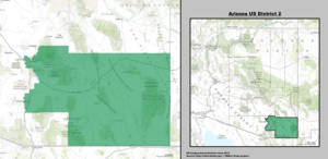
For the 118th and successive Congresses (based on redistricting following the 2020 census), the district contains the following counties and communities:[5]
Starting with the 1948 elections, Arizona began using separate districts to elect its members to the House of Representatives rather than using a general ticket due to having gained a second seat in the House with the data from 1940 Census.
This page is based on this Wikipedia article Text is available under the CC BY-SA 4.0 license; additional terms may apply. Images, videos and audio are available under their respective licenses.